Lake Insula Topo Map Minnesota
To zoom in, hover over the map of Lake Insula
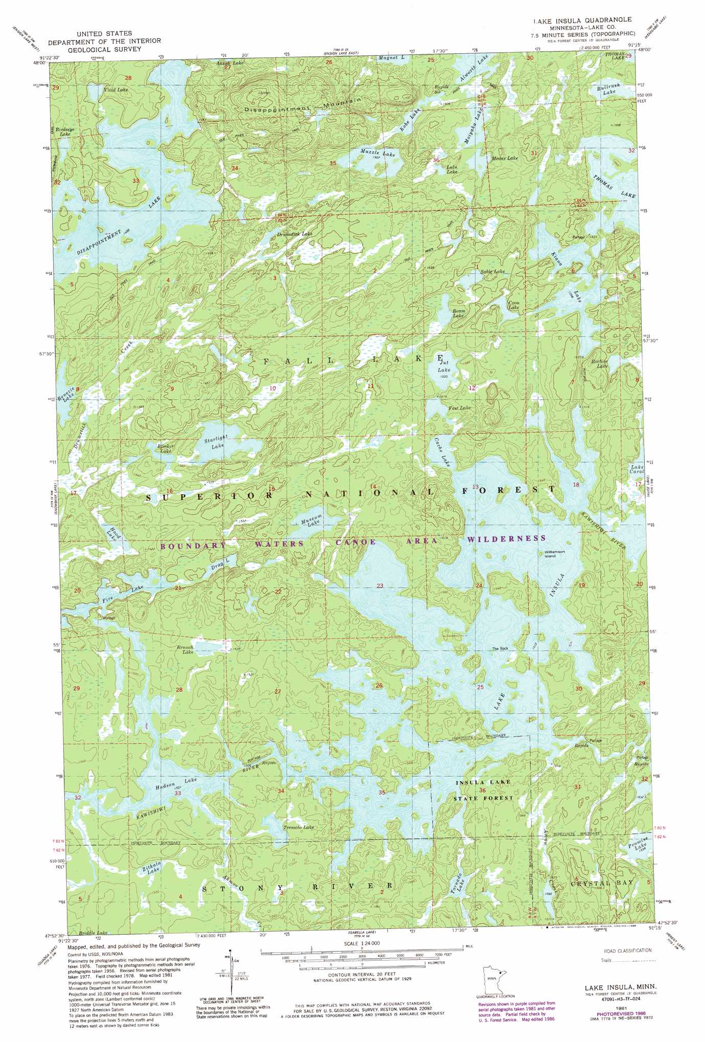
USGS Topo Quad 47091h3 - 1:24,000 scale
| Topo Map Name: | Lake Insula |
| USGS Topo Quad ID: | 47091h3 |
| Print Size: | ca. 21 1/4" wide x 27" high |
| Southeast Coordinates: | 47.875° N latitude / 91.25° W longitude |
| Map Center Coordinates: | 47.9375° N latitude / 91.3125° W longitude |
| U.S. State: | MN |
| Filename: | o47091h3.jpg |
| Download Map JPG Image: | Lake Insula topo map 1:24,000 scale |
| Map Type: | Topographic |
| Topo Series: | 7.5´ |
| Map Scale: | 1:24,000 |
| Source of Map Images: | United States Geological Survey (USGS) |
| Alternate Map Versions: |
Lake Insula MN 1981, updated 1981 Download PDF Buy paper map Lake Insula MN 1981, updated 1986 Download PDF Buy paper map Lake Insula MN 2011 Download PDF Buy paper map Lake Insula MN 2013 Download PDF Buy paper map Lake Insula MN 2016 Download PDF Buy paper map |
| FStopo: | US Forest Service topo Lake Insula is available: Download FStopo PDF Download FStopo TIF |
1:24,000 Topo Quads surrounding Lake Insula
Dutton Lake |
Ester Lake |
|||
Basswood Lake East |
Ensign Lake West |
Ensign Lake East |
Kekekabic Lake |
Ogishkemuncie Lake |
Ojibway Lake |
Snowbank Lake |
Lake Insula |
Alice Lake |
Lake Polly |
Gabbro Lake |
Quadga Lake |
Isabella Lake |
Perent Lake |
Kawishiwi Lake |
Slate Lake East |
Mitawan Lake |
Sawbill Landing |
Silver Island Lake |
Wilson Lake |
> Back to 47091e1 at 1:100,000 scale
> Back to 47090a1 at 1:250,000 scale
> Back to U.S. Topo Maps home
Lake Insula topo map: Gazetteer
Lake Insula: Forests
Lake Insula State Forest elevation 468m 1535′Lake Insula: Islands
The Rock elevation 475m 1558′Williamson Island elevation 461m 1512′
Lake Insula: Lakes
Beam Lake elevation 474m 1555′Benezie Lake elevation 467m 1532′
Birdsey Lake elevation 461m 1512′
Blinker Lake elevation 473m 1551′
Brunch Lake elevation 467m 1532′
Bullrush Lake elevation 473m 1551′
Cache Lake elevation 461m 1512′
Coon Lake elevation 481m 1578′
Disappointment Lake elevation 452m 1482′
Drag Lake elevation 457m 1499′
Drumstick Lake elevation 481m 1578′
Fast Lake elevation 462m 1515′
Fire Lake elevation 455m 1492′
Hood Lake elevation 463m 1519′
Hudson Lake elevation 458m 1502′
Jut Lake elevation 467m 1532′
Kiana Lake elevation 478m 1568′
Kobe Lake elevation 461m 1512′
Lake Insula elevation 461m 1512′
Lulu Lake elevation 474m 1555′
Magnet Lake elevation 467m 1532′
Medas Lake elevation 473m 1551′
Moiyaka Lake elevation 473m 1551′
Museum Lake elevation 479m 1571′
Muzzle Lake elevation 461m 1512′
Promise Lake elevation 469m 1538′
Recline Lake elevation 481m 1578′
Sable Lake elevation 481m 1578′
Starlight Lake elevation 474m 1555′
Tornado Lake elevation 462m 1515′
Tremolo Lake elevation 463m 1519′
Vivid Lake elevation 454m 1489′
Zitkala Lake elevation 463m 1519′
Lake Insula: Streams
Ahmoo Creek elevation 458m 1502′Lake Insula: Summits
Disappointment Mountain elevation 557m 1827′Lake Insula: Trails
Old Pines Trail elevation 470m 1541′Lake Insula digital topo map on disk
Buy this Lake Insula topo map showing relief, roads, GPS coordinates and other geographical features, as a high-resolution digital map file on DVD: