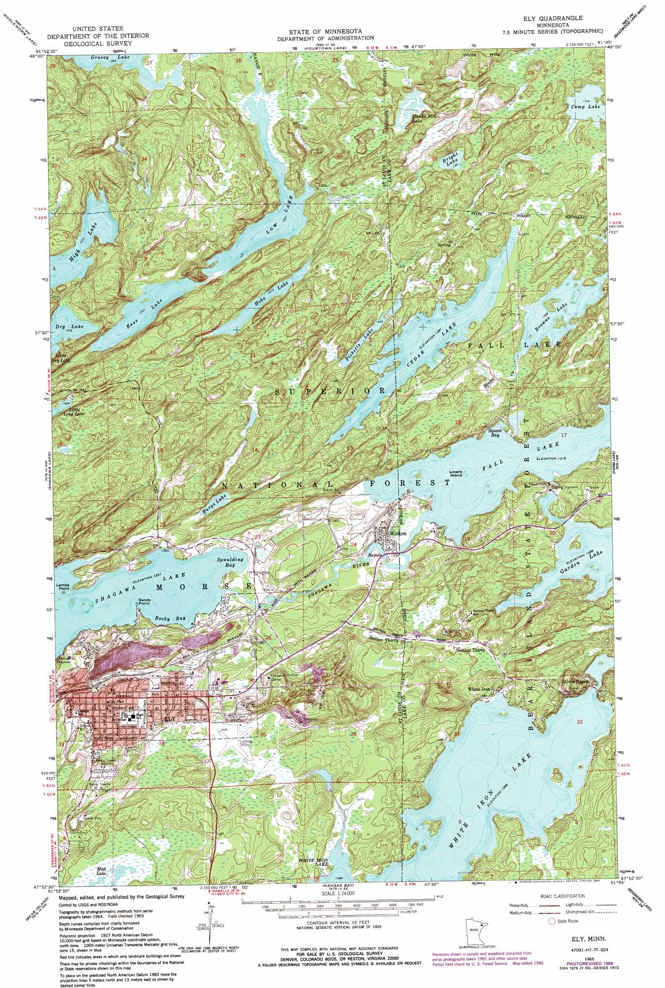
Ely Topo Map Minnesota
To zoom in, hover over the map of Ely
USGS Topo Quad 47091h7 - 1:24,000 scale
| Topo Map Name: | Ely |
| USGS Topo Quad ID: | 47091h7 |
| Print Size: | ca. 21 1/4" wide x 27" high |
| Southeast Coordinates: | 47.875° N latitude / 91.75° W longitude |
| Map Center Coordinates: | 47.9375° N latitude / 91.8125° W longitude |
| U.S. State: | MN |
| Filename: | o47091h7.jpg |
| Download Map JPG Image: | Ely topo map 1:24,000 scale |
| Map Type: | Topographic |
| Topo Series: | 7.5´ |
| Map Scale: | 1:24,000 |
| Source of Map Images: | United States Geological Survey (USGS) |
| Alternate Map Versions: |
Ely MN 1965, updated 1967 Download PDF Buy paper map Ely MN 1965, updated 1973 Download PDF Buy paper map Ely MN 1965, updated 1986 Download PDF Buy paper map Ely MN 2011 Download PDF Buy paper map Ely MN 2013 Download PDF Buy paper map Ely MN 2016 Download PDF Buy paper map |
| FStopo: | US Forest Service topo Ely is available: Download FStopo PDF Download FStopo TIF |
1:24,000 Topo Quads surrounding Ely
Lake Agnes |
Iron Lake |
Friday Bay |
Jackfish Lake |
|
Lapond Lake |
Angleworm Lake |
Fourtown Lake |
Basswood Lake West |
Basswood Lake East |
Crab Lake |
Shagawa Lake |
Ely |
Farm Lake |
Ojibway Lake |
Eagles Nest |
Bear Island |
Kangas Bay |
Bogberry Lake |
Gabbro Lake |
Isaac Lake |
Babbitt |
Babbitt Ne |
Slate Lake West |
Slate Lake East |
> Back to 47091e1 at 1:100,000 scale
> Back to 47090a1 at 1:250,000 scale
> Back to U.S. Topo Maps home
Ely topo map: Gazetteer
Ely: Airports
Ely Bloomenson Heliport elevation 441m 1446′Ely: Bays
Mist Bay elevation 401m 1315′Rocky Bay elevation 408m 1338′
Spaulding Bay elevation 408m 1338′
Ely: Capes
Lambs Point elevation 408m 1338′Sandy Point elevation 408m 1338′
Ely: Dams
Winton Dam elevation 424m 1391′Ely: Islands
Lovers Island elevation 402m 1318′Ely: Lakes
Bass Lake elevation 414m 1358′Bright Lake elevation 424m 1391′
Browns Lake elevation 417m 1368′
Burgo Lake elevation 413m 1354′
Camp Lake elevation 419m 1374′
Cedar Lake elevation 424m 1391′
Dry Lake elevation 420m 1377′
Fall Lake elevation 401m 1315′
Garden Lake elevation 422m 1384′
Hawks Nest Lake elevation 422m 1384′
High Lake elevation 438m 1437′
Hobo Lake elevation 431m 1414′
Low Lake elevation 412m 1351′
Miners Lake elevation 404m 1325′
Picketts Lake elevation 430m 1410′
Ely: Mines
Pioneer Mine elevation 404m 1325′Ely: Parks
Whiteside Park elevation 445m 1459′Ely: Populated Places
Ely elevation 436m 1430′Northern Terrace Mobile Home Park elevation 436m 1430′
Section Thirty elevation 426m 1397′
Silver Rapids elevation 426m 1397′
White Iron elevation 426m 1397′
Winton elevation 406m 1332′
Ely: Post Offices
Ely Post Office elevation 447m 1466′Section Thirty Post Office (historical) elevation 426m 1397′
Sellwood Post Office (historical) elevation 426m 1397′
Winton Post Office elevation 405m 1328′
Ely: Reservoirs
Garden Lake elevation 424m 1391′Ely: Streams
Fall Creek elevation 404m 1325′Section Thirty Creek elevation 402m 1318′
Shagawa River elevation 401m 1315′
Ely: Summits
White Hills elevation 451m 1479′Ely: Trails
Trezona Trail elevation 420m 1377′Ely digital topo map on disk
Buy this Ely topo map showing relief, roads, GPS coordinates and other geographical features, as a high-resolution digital map file on DVD: