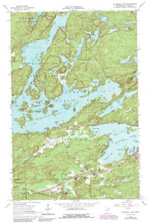
Shagawa Lake Topo Map Minnesota
To zoom in, hover over the map of Shagawa Lake
USGS Topo Quad 47091h8 - 1:24,000 scale
| Topo Map Name: | Shagawa Lake |
| USGS Topo Quad ID: | 47091h8 |
| Print Size: | ca. 21 1/4" wide x 27" high |
| Southeast Coordinates: | 47.875° N latitude / 91.875° W longitude |
| Map Center Coordinates: | 47.9375° N latitude / 91.9375° W longitude |
| U.S. State: | MN |
| Filename: | o47091h8.jpg |
| Download Map JPG Image: | Shagawa Lake topo map 1:24,000 scale |
| Map Type: | Topographic |
| Topo Series: | 7.5´ |
| Map Scale: | 1:24,000 |
| Source of Map Images: | United States Geological Survey (USGS) |
| Alternate Map Versions: |
Shagawa Lake MN 1965, updated 1967 Download PDF Buy paper map Shagawa Lake MN 1965, updated 1974 Download PDF Buy paper map Shagawa Lake MN 1965, updated 1986 Download PDF Buy paper map Shagawa Lake MN 2011 Download PDF Buy paper map Shagawa Lake MN 2013 Download PDF Buy paper map Shagawa Lake MN 2016 Download PDF Buy paper map |
| FStopo: | US Forest Service topo Shagawa Lake is available: Download FStopo PDF Download FStopo TIF |
1:24,000 Topo Quads surrounding Shagawa Lake
> Back to 47091e1 at 1:100,000 scale
> Back to 47090a1 at 1:250,000 scale
> Back to U.S. Topo Maps home
Shagawa Lake topo map: Gazetteer
Shagawa Lake: Airports
Shagawa Lake Seaplane Base elevation 408m 1338′Shagawa Lake: Bays
Birch Bay elevation 418m 1371′Boulder Bay elevation 408m 1338′
Furaganger Bay elevation 418m 1371′
Longstorff Bay elevation 408m 1338′
North Arm elevation 418m 1371′
Olson Bay elevation 408m 1338′
Schaefer Bay elevation 408m 1338′
School Section Bay elevation 418m 1371′
Shagawa Lake: Capes
Crossman Point elevation 408m 1338′Hartley Point elevation 418m 1371′
Litner Point elevation 418m 1371′
Miller Point elevation 408m 1338′
Shagawa Lake: Dams
Pioneer Clarification Dike elevation 421m 1381′Pioneer Tailings Dike elevation 439m 1440′
Shagawa Lake: Islands
Berry Island elevation 431m 1414′Big Island elevation 414m 1358′
Blueberry Island elevation 426m 1397′
Brownell Island elevation 428m 1404′
Evans Island elevation 426m 1397′
Honeymoon Island elevation 430m 1410′
Hoodoo Island elevation 412m 1351′
Indian Island elevation 422m 1384′
Lockhart Island elevation 429m 1407′
Lost Girl Island elevation 439m 1440′
Miller Island elevation 435m 1427′
Okorb Island elevation 408m 1338′
Oliver Island elevation 421m 1381′
Ripple Island elevation 447m 1466′
Shipman Island elevation 408m 1338′
Snake Island elevation 438m 1437′
State Island elevation 425m 1394′
Sumpter Island elevation 428m 1404′
Valentine Island elevation 422m 1384′
Waters Island elevation 433m 1420′
Shagawa Lake: Lakes
Burntside Lake elevation 418m 1371′Chant Lake elevation 435m 1427′
Everett Lake elevation 420m 1377′
Fenske Lake elevation 441m 1446′
Hanson Lake elevation 426m 1397′
Little Dry Lake elevation 420m 1377′
Little Long Lake elevation 433m 1420′
Little Sletten Lake elevation 444m 1456′
Minister Lake elevation 421m 1381′
Shagawa Lake elevation 408m 1338′
Shipman Bass Lake elevation 424m 1391′
Sletten Lake elevation 454m 1489′
Twin Lakes elevation 418m 1371′
Shagawa Lake: Parks
Semer Park elevation 411m 1348′Shagawa Lake: Populated Places
Burntside elevation 424m 1391′Shagawa Lake: Post Offices
Burntside Post Office (historical) elevation 424m 1391′Shagawa Lake: Reservoirs
Pioneer Clarification Basin elevation 421m 1381′Pioneer Tailings Basin elevation 439m 1440′
Shagawa Lake: Streams
Armstrong Creek elevation 408m 1338′Burntside River elevation 408m 1338′
Dead River elevation 418m 1371′
Longstorff Creek elevation 408m 1338′
Shagawa Lake digital topo map on disk
Buy this Shagawa Lake topo map showing relief, roads, GPS coordinates and other geographical features, as a high-resolution digital map file on DVD:


