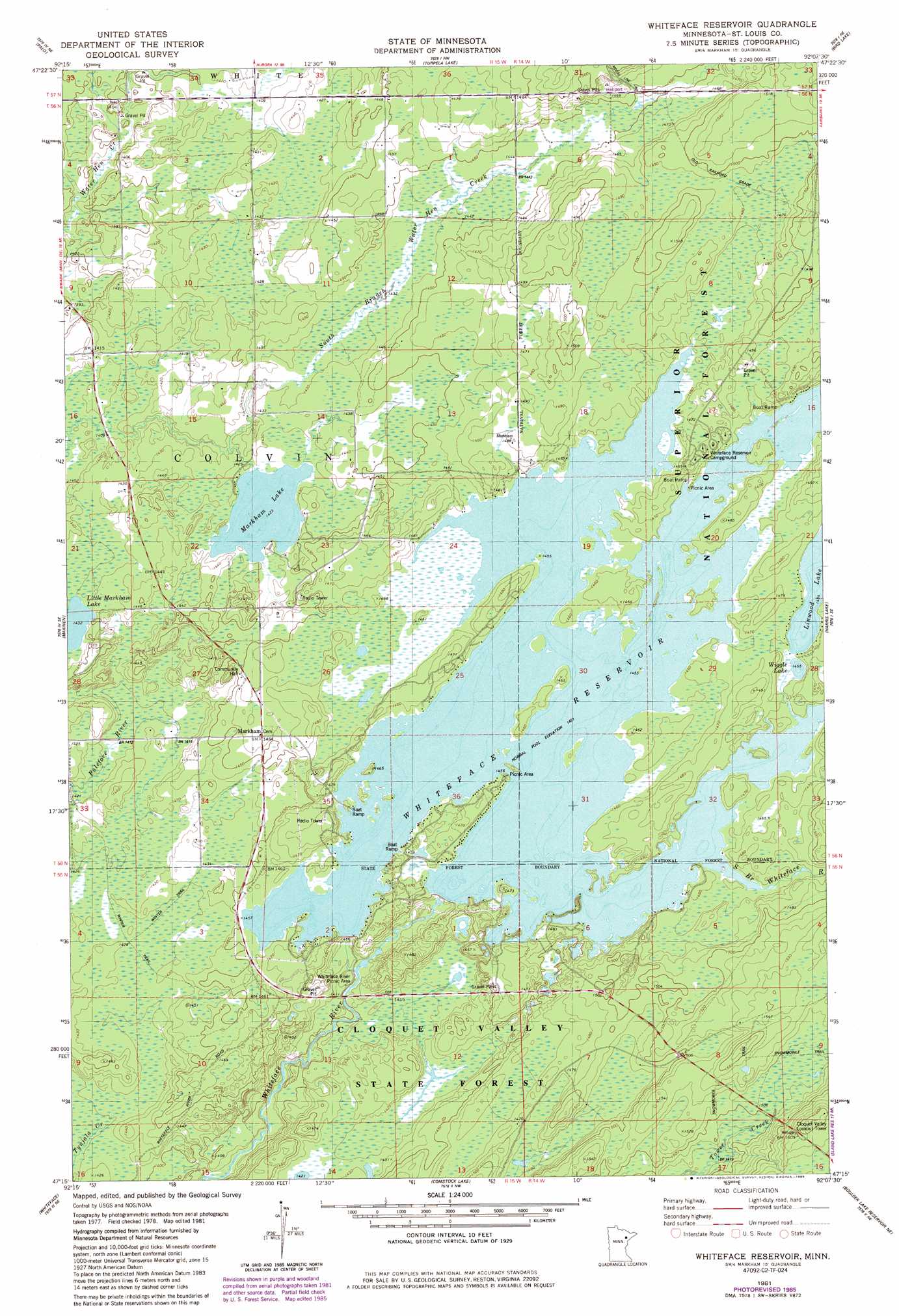
Whiteface Reservoir Topo Map Minnesota
To zoom in, hover over the map of Whiteface Reservoir
USGS Topo Quad 47092c2 - 1:24,000 scale
| Topo Map Name: | Whiteface Reservoir |
| USGS Topo Quad ID: | 47092c2 |
| Print Size: | ca. 21 1/4" wide x 27" high |
| Southeast Coordinates: | 47.25° N latitude / 92.125° W longitude |
| Map Center Coordinates: | 47.3125° N latitude / 92.1875° W longitude |
| U.S. State: | MN |
| Filename: | o47092c2.jpg |
| Download Map JPG Image: | Whiteface Reservoir topo map 1:24,000 scale |
| Map Type: | Topographic |
| Topo Series: | 7.5´ |
| Map Scale: | 1:24,000 |
| Source of Map Images: | United States Geological Survey (USGS) |
| Alternate Map Versions: |
Whiteface Reservoir MN 1981, updated 1982 Download PDF Buy paper map Whiteface Reservoir MN 1981, updated 1985 Download PDF Buy paper map Whiteface Reservoir MN 2011 Download PDF Buy paper map Whiteface Reservoir MN 2013 Download PDF Buy paper map Whiteface Reservoir MN 2016 Download PDF Buy paper map |
| FStopo: | US Forest Service topo Whiteface Reservoir is available: Download FStopo PDF Download FStopo TIF |
1:24,000 Topo Quads surrounding Whiteface Reservoir
Mckinley |
Biwabik |
Aurora |
Allen |
Babbitt Sw |
Gilbert |
Palo |
Turpela Lake |
Bird Lake |
Skibo |
Central Lakes |
Makinen |
Whiteface Reservoir |
Harris Lake |
Fairbanks |
Cotton |
Whiteface |
Comstock Lake |
Boulder Lake Reservoir Ne |
Pequaywan Lake |
Canyon |
Shaw |
Boulder Lake Reservoir |
Thompson Lake |
Barrs Lake |
> Back to 47092a1 at 1:100,000 scale
> Back to 47092a1 at 1:250,000 scale
> Back to U.S. Topo Maps home
Whiteface Reservoir topo map: Gazetteer
Whiteface Reservoir: Dams
White Face Lake Dam elevation 430m 1410′Whiteface Lake Section Three Dam elevation 446m 1463′
Whiteface Lake Section Two Dam elevation 433m 1420′
Whiteface Reservoir: Lakes
Little Markham Lake elevation 437m 1433′Markham Lake elevation 434m 1423′
Wiggle Lake elevation 444m 1456′
Whiteface Reservoir: Populated Places
Markham elevation 446m 1463′Whiteface Reservoir: Post Offices
Markham Post Office (historical) elevation 446m 1463′Whiteface Reservoir: Reservoirs
Whiteface Lake elevation 446m 1463′Whiteface Lake Reservoir elevation 430m 1410′
Whiteface Reservoir elevation 441m 1446′
Whiteface Reservoir: Streams
South Branch Whiteface River elevation 442m 1450′Whiteface Reservoir digital topo map on disk
Buy this Whiteface Reservoir topo map showing relief, roads, GPS coordinates and other geographical features, as a high-resolution digital map file on DVD: