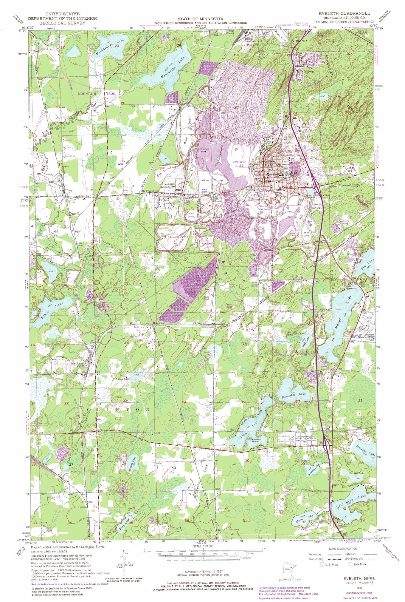
Eveleth Topo Map Minnesota
To zoom in, hover over the map of Eveleth
USGS Topo Quad 47092d5 - 1:24,000 scale
| Topo Map Name: | Eveleth |
| USGS Topo Quad ID: | 47092d5 |
| Print Size: | ca. 21 1/4" wide x 27" high |
| Southeast Coordinates: | 47.375° N latitude / 92.5° W longitude |
| Map Center Coordinates: | 47.4375° N latitude / 92.5625° W longitude |
| U.S. State: | MN |
| Filename: | o47092d5.jpg |
| Download Map JPG Image: | Eveleth topo map 1:24,000 scale |
| Map Type: | Topographic |
| Topo Series: | 7.5´ |
| Map Scale: | 1:24,000 |
| Source of Map Images: | United States Geological Survey (USGS) |
| Alternate Map Versions: |
Eveleth MN 1951, updated 1952 Download PDF Buy paper map Eveleth MN 1951, updated 1962 Download PDF Buy paper map Eveleth MN 1951, updated 1968 Download PDF Buy paper map Eveleth MN 1951, updated 1971 Download PDF Buy paper map Eveleth MN 1951, updated 1983 Download PDF Buy paper map Eveleth MN 2010 Download PDF Buy paper map Eveleth MN 2013 Download PDF Buy paper map Eveleth MN 2016 Download PDF Buy paper map |
1:24,000 Topo Quads surrounding Eveleth
Dark Lake |
Idington |
Britt |
Biwabik Nw |
Biwabik Ne |
Dewey Lake Se |
Kinney |
Virginia |
Mckinley |
Biwabik |
Buhl |
Kirk |
Eveleth |
Gilbert |
Palo |
Little Swan |
Casco |
Zim |
Central Lakes |
Makinen |
Toivola |
Meadowlands Nw |
Kelsey |
Cotton |
Whiteface |
> Back to 47092a1 at 1:100,000 scale
> Back to 47092a1 at 1:250,000 scale
> Back to U.S. Topo Maps home
Eveleth topo map: Gazetteer
Eveleth: Islands
Kalleva Island elevation 414m 1358′Eveleth: Lakes
Borg Lake elevation 410m 1345′Elbow Lake elevation 416m 1364′
Fayal Pond elevation 473m 1551′
Half Moon Lake elevation 411m 1348′
Harvey Lake elevation 414m 1358′
Horseshoe Lake elevation 414m 1358′
Kapla Lake elevation 414m 1358′
Keenan Lake elevation 414m 1358′
Long Lake elevation 414m 1358′
Manganika Lake elevation 428m 1404′
Mashkenode Lake elevation 428m 1404′
Moon Lake elevation 411m 1348′
Mud Lake elevation 501m 1643′
Mud Lake elevation 414m 1358′
Saint Marys Lake elevation 420m 1377′
Warren Lake elevation 409m 1341′
Eveleth: Mines
Adams Pit elevation 476m 1561′Auburn Pit elevation 468m 1535′
Burns Mine elevation 457m 1499′
Fayal Number Two Pit elevation 472m 1548′
Fayal Pit elevation 471m 1545′
Hull-Nelson Mine elevation 467m 1532′
Leonidas Mine elevation 448m 1469′
Morrow Mine elevation 457m 1499′
Spruce Mine elevation 467m 1532′
Virginia Mine elevation 471m 1545′
Eveleth: Parks
Monroe Park elevation 476m 1561′Northside Park elevation 475m 1558′
Saint Marys Lake Wayside Park elevation 425m 1394′
Soutside Park elevation 487m 1597′
Eveleth: Populated Places
De Forest elevation 433m 1420′Eveleth elevation 485m 1591′
Genoa elevation 488m 1601′
Iron Junction elevation 423m 1387′
Keenan elevation 413m 1354′
Largo elevation 435m 1427′
Leonidas elevation 439m 1440′
Midway elevation 516m 1692′
Rainy Junction elevation 442m 1450′
Ramshaw elevation 430m 1410′
Snowden elevation 459m 1505′
Spruce elevation 430m 1410′
Wolf elevation 429m 1407′
Eveleth: Post Offices
Eveleth Post Office elevation 493m 1617′Iron Post Office elevation 423m 1387′
Midway Post Office (historical) elevation 516m 1692′
Eveleth digital topo map on disk
Buy this Eveleth topo map showing relief, roads, GPS coordinates and other geographical features, as a high-resolution digital map file on DVD: