Aurora Topo Map Minnesota
To zoom in, hover over the map of Aurora
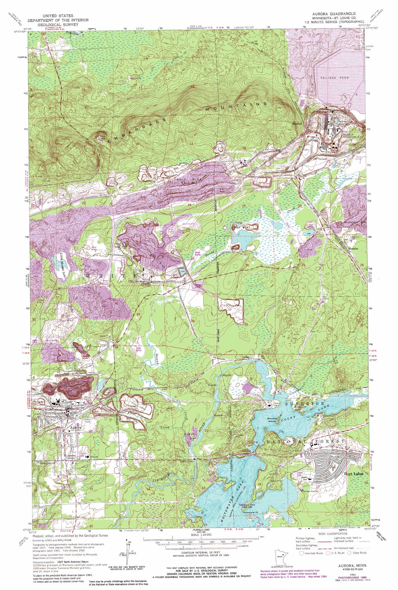
USGS Topo Quad 47092e2 - 1:24,000 scale
| Topo Map Name: | Aurora |
| USGS Topo Quad ID: | 47092e2 |
| Print Size: | ca. 21 1/4" wide x 27" high |
| Southeast Coordinates: | 47.5° N latitude / 92.125° W longitude |
| Map Center Coordinates: | 47.5625° N latitude / 92.1875° W longitude |
| U.S. State: | MN |
| Filename: | o47092e2.jpg |
| Download Map JPG Image: | Aurora topo map 1:24,000 scale |
| Map Type: | Topographic |
| Topo Series: | 7.5´ |
| Map Scale: | 1:24,000 |
| Source of Map Images: | United States Geological Survey (USGS) |
| Alternate Map Versions: |
Aurora MN 1949, updated 1956 Download PDF Buy paper map Aurora MN 1950 Download PDF Buy paper map Aurora MN 1962, updated 1964 Download PDF Buy paper map Aurora MN 1962, updated 1971 Download PDF Buy paper map Aurora MN 1962, updated 1983 Download PDF Buy paper map Aurora MN 2011 Download PDF Buy paper map Aurora MN 2013 Download PDF Buy paper map Aurora MN 2016 Download PDF Buy paper map |
| FStopo: | US Forest Service topo Aurora is available: Download FStopo PDF Download FStopo TIF |
1:24,000 Topo Quads surrounding Aurora
Lost Lake |
Tower |
Soudan |
Eagles Nest |
Bear Island |
Biwabik Nw |
Biwabik Ne |
Embarrass |
Isaac Lake |
Babbitt |
Mckinley |
Biwabik |
Aurora |
Allen |
Babbitt Sw |
Gilbert |
Palo |
Turpela Lake |
Bird Lake |
Skibo |
Central Lakes |
Makinen |
Whiteface Reservoir |
Harris Lake |
Fairbanks |
> Back to 47092e1 at 1:100,000 scale
> Back to 47092a1 at 1:250,000 scale
> Back to U.S. Topo Maps home
Aurora topo map: Gazetteer
Aurora: Basins
Erie Mine Number One Pit elevation 512m 1679′Aurora: Capes
Kumpula Point elevation 439m 1440′Aurora: Dams
Donora Settling Dike elevation 481m 1578′East Stephens Settling Dike elevation 452m 1482′
Erie Basin One Dike elevation 541m 1774′
Erie Basin Two Dike elevation 472m 1548′
West Stephens Settling Dike elevation 466m 1528′
White Water Reservoir Dam elevation 431m 1414′
Aurora: Islands
Smolich Island elevation 440m 1443′Aurora: Lakes
Colby Lake elevation 439m 1440′Little Lake elevation 439m 1440′
Little Mesaba Lake elevation 475m 1558′
Aurora: Mines
Knox Mine elevation 454m 1489′Saint James Mine elevation 447m 1466′
Stephens Mine elevation 459m 1505′
Wentworth Mine elevation 463m 1519′
Aurora: Populated Places
Aurora elevation 451m 1479′Colby elevation 439m 1440′
Hinsdale elevation 495m 1624′
Hoyt Lakes elevation 449m 1473′
Mesaba elevation 466m 1528′
Old Mesaba elevation 466m 1528′
Aurora: Post Offices
Aurora Post Office elevation 450m 1476′Hinsdale Post Office (historical) elevation 497m 1630′
Hoyt Lakes Post Office elevation 446m 1463′
Mesaba Post Office (historical) elevation 467m 1532′
Aurora: Ranges
Embarrass Mountains elevation 567m 1860′Aurora: Reservoirs
Donora Settling Basin elevation 481m 1578′East Stephens Settling Basin elevation 452m 1482′
Erie Basin One elevation 541m 1774′
Erie Basin Two elevation 472m 1548′
West Stephens Settling Basin elevation 466m 1528′
White Water Reservoir elevation 431m 1414′
Aurora: Streams
First Creek elevation 428m 1404′Second Creek elevation 430m 1410′
Stephens Creek elevation 445m 1459′
Aurora digital topo map on disk
Buy this Aurora topo map showing relief, roads, GPS coordinates and other geographical features, as a high-resolution digital map file on DVD: