Remer Topo Map Minnesota
To zoom in, hover over the map of Remer
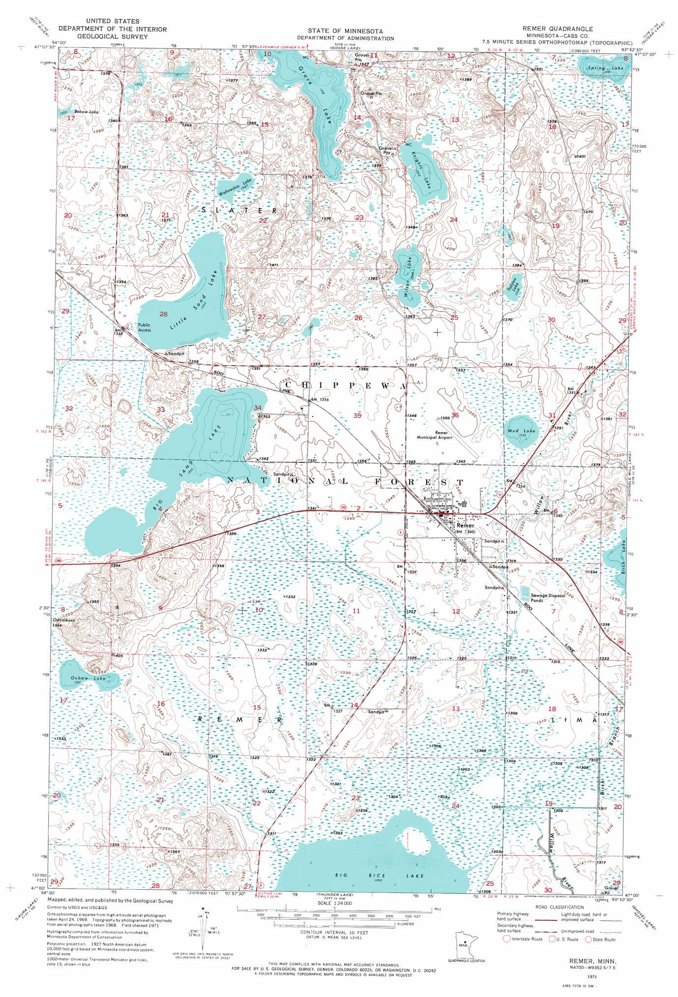
USGS Topo Quad 47093a8 - 1:24,000 scale
| Topo Map Name: | Remer |
| USGS Topo Quad ID: | 47093a8 |
| Print Size: | ca. 21 1/4" wide x 27" high |
| Southeast Coordinates: | 47° N latitude / 93.875° W longitude |
| Map Center Coordinates: | 47.0625° N latitude / 93.9375° W longitude |
| U.S. State: | MN |
| Filename: | o47093a8.jpg |
| Download Map JPG Image: | Remer topo map 1:24,000 scale |
| Map Type: | Topographic |
| Topo Series: | 7.5´ |
| Map Scale: | 1:24,000 |
| Source of Map Images: | United States Geological Survey (USGS) |
| Alternate Map Versions: |
Remer MN 1971, updated 1973 Download PDF Buy paper map Remer MN 1971, updated 1974 Download PDF Buy paper map Remer MN 1996, updated 1998 Download PDF Buy paper map Remer MN 2011 Download PDF Buy paper map Remer MN 2013 Download PDF Buy paper map Remer MN 2016 Download PDF Buy paper map |
| FStopo: | US Forest Service topo Remer is available: Download FStopo PDF Download FStopo TIF |
1:24,000 Topo Quads surrounding Remer
Bena |
Nushka Lake |
Ball Club |
Deer River |
Cohasset West |
Federal Dam |
Boy River |
Goose Lake |
Sugar Lake |
Siseebakwet Lake |
Town Line Lake |
Tobique |
Remer |
Shingle Mill Lake |
Big Thunder Peak |
Longville |
Laura Lake |
Thunder Lake |
Shovel Lake |
Swatara |
Stewart Lake |
Mitchell Lake |
Roosevelt Lake |
Edna Lake |
White Elk Lake |
> Back to 47093a1 at 1:100,000 scale
> Back to 47092a1 at 1:250,000 scale
> Back to U.S. Topo Maps home
Remer topo map: Gazetteer
Remer: Airports
Remer Municipal Airport elevation 411m 1348′Remer: Dams
Loon Lake Dam elevation 422m 1384′Remer: Lakes
Big Sand Lake elevation 407m 1335′Folston Lake elevation 414m 1358′
Grave Lake elevation 402m 1318′
Knights Lake elevation 410m 1345′
Little Sand Lake elevation 409m 1341′
Mud Lake elevation 407m 1335′
Oxbow Lake elevation 406m 1332′
Spring Lake elevation 402m 1318′
Wahneshin Lake elevation 411m 1348′
Wilson Lake elevation 411m 1348′
Remer: Populated Places
Remer elevation 409m 1341′Remer: Post Offices
Remer Post Office elevation 409m 1341′Remer: Reservoirs
Loon Lake elevation 422m 1384′Remer: Streams
Birch Branch elevation 397m 1302′Remer digital topo map on disk
Buy this Remer topo map showing relief, roads, GPS coordinates and other geographical features, as a high-resolution digital map file on DVD: