Lawrence Lake West Topo Map Minnesota
To zoom in, hover over the map of Lawrence Lake West
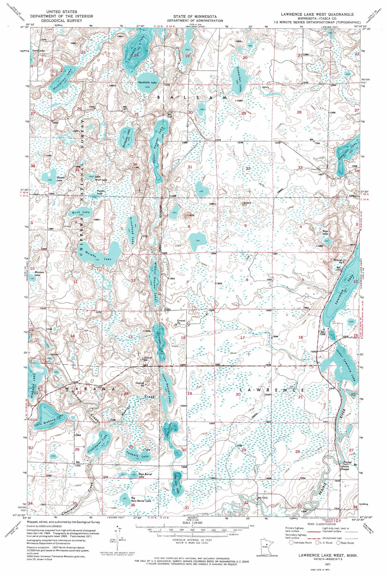
USGS Topo Quad 47093d4 - 1:24,000 scale
| Topo Map Name: | Lawrence Lake West |
| USGS Topo Quad ID: | 47093d4 |
| Print Size: | ca. 21 1/4" wide x 27" high |
| Southeast Coordinates: | 47.375° N latitude / 93.375° W longitude |
| Map Center Coordinates: | 47.4375° N latitude / 93.4375° W longitude |
| U.S. State: | MN |
| Filename: | o47093d4.jpg |
| Download Map JPG Image: | Lawrence Lake West topo map 1:24,000 scale |
| Map Type: | Topographic |
| Topo Series: | 7.5´ |
| Map Scale: | 1:24,000 |
| Source of Map Images: | United States Geological Survey (USGS) |
| Alternate Map Versions: |
Lawrence Lake West MN 1996, updated 1998 Download PDF Buy paper map Lawrence Lake West MN 2011 Download PDF Buy paper map Lawrence Lake West MN 2013 Download PDF Buy paper map Lawrence Lake West MN 2016 Download PDF Buy paper map |
| FStopo: | US Forest Service topo Lawrence Lake West is available: Download FStopo PDF Download FStopo TIF |
1:24,000 Topo Quads surrounding Lawrence Lake West
Bigfork |
Coon Lake |
Anderson Lake |
Horsehead Lake |
Sherry Lake |
Marcell |
Clubhouse Lake |
Balsam Lake |
Hartley Lake |
O'Leary Lake |
Little Bowstring Lake |
Wabana Lake |
Lawrence Lake West |
Lawrence Lake East |
Nashwauk |
Cohasset West |
Cohasset East |
Bovey |
Calumet |
Pengilly |
Siseebakwet Lake |
Grand Rapids |
La Prairie |
Warba |
Goodland |
> Back to 47093a1 at 1:100,000 scale
> Back to 47092a1 at 1:250,000 scale
> Back to U.S. Topo Maps home
Lawrence Lake West topo map: Gazetteer
Lawrence Lake West: Airports
Shaughnessy Seaplane Base elevation 397m 1302′Lawrence Lake West: Dams
Little Wolf Lake Wildlife Impondment Dam elevation 424m 1391′Wabana Lake Dam elevation 402m 1318′
Lawrence Lake West: Lakes
Arrowhead Lake elevation 408m 1338′Big Rain Barrel Lake elevation 400m 1312′
Birch Lake elevation 408m 1338′
Camerton Lake elevation 415m 1361′
Clearwater Lake elevation 398m 1305′
Cutaway Lake elevation 411m 1348′
Hanson Lake elevation 399m 1309′
Hendrichs Lake elevation 411m 1348′
Inky Lake elevation 400m 1312′
Lawrence Lake elevation 396m 1299′
Little Inky Lake elevation 402m 1318′
Little Wabana Lake elevation 403m 1322′
Little Wolf Lake elevation 409m 1341′
Lower Hanson Lake elevation 399m 1309′
Lower Lawrence Lake elevation 396m 1299′
McAlpine Lake elevation 408m 1338′
Middle Hanson Lake elevation 399m 1309′
Minnow Lake elevation 415m 1361′
Murphy Lake elevation 408m 1338′
Plantation Lake elevation 411m 1348′
Potato Lake elevation 408m 1338′
Rain Barrel Lake elevation 401m 1315′
Rose Lake elevation 406m 1332′
Skeeter Lake elevation 422m 1384′
Snaptail Lake elevation 407m 1335′
Tadpole Lake elevation 400m 1312′
Upper Hanson Lake elevation 400m 1312′
Lawrence Lake West: Post Offices
Wabana Lake Post Office (historical) elevation 419m 1374′Wabana Post Office (historical) elevation 419m 1374′
Lawrence Lake West: Reservoirs
Hanson Lake Impoundment elevation 402m 1318′Little Wolf Impoundment elevation 419m 1374′
Little Wolf Lake elevation 424m 1391′
Wabana Lake elevation 402m 1318′
Lawrence Lake West: Streams
Hanson Creek elevation 398m 1305′Sucker Brook elevation 396m 1299′
Wabana Creek elevation 398m 1305′
Lawrence Lake West: Trails
Skeeter Lake Trail System elevation 427m 1400′Lawrence Lake West digital topo map on disk
Buy this Lawrence Lake West topo map showing relief, roads, GPS coordinates and other geographical features, as a high-resolution digital map file on DVD: