Stingy Lake Topo Map Minnesota
To zoom in, hover over the map of Stingy Lake
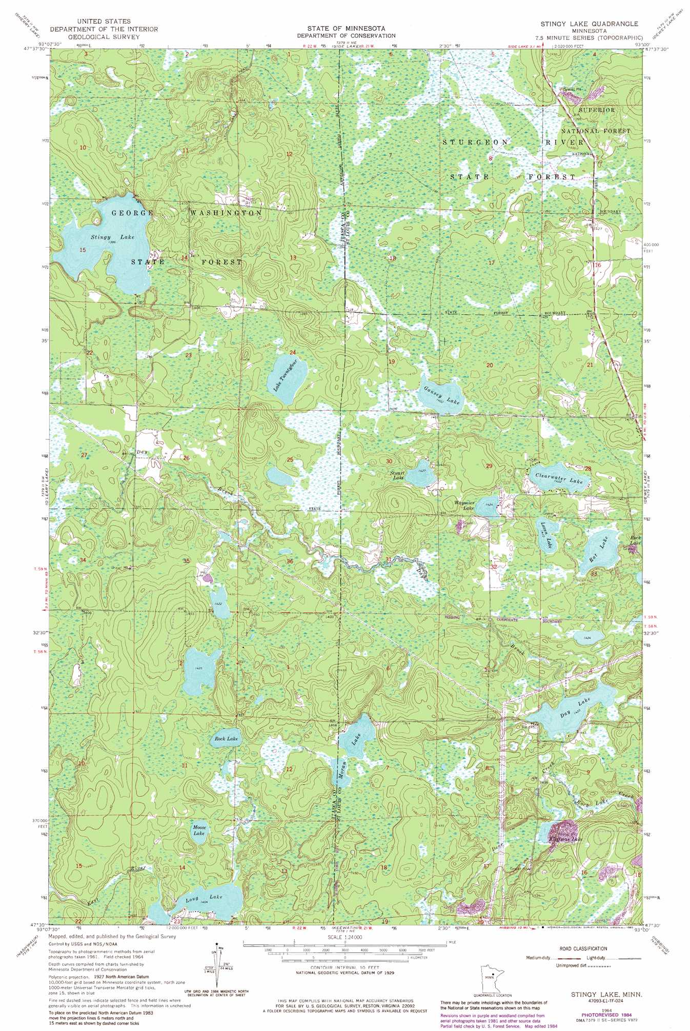
USGS Topo Quad 47093e1 - 1:24,000 scale
| Topo Map Name: | Stingy Lake |
| USGS Topo Quad ID: | 47093e1 |
| Print Size: | ca. 21 1/4" wide x 27" high |
| Southeast Coordinates: | 47.5° N latitude / 93° W longitude |
| Map Center Coordinates: | 47.5625° N latitude / 93.0625° W longitude |
| U.S. State: | MN |
| Filename: | o47093e1.jpg |
| Download Map JPG Image: | Stingy Lake topo map 1:24,000 scale |
| Map Type: | Topographic |
| Topo Series: | 7.5´ |
| Map Scale: | 1:24,000 |
| Source of Map Images: | United States Geological Survey (USGS) |
| Alternate Map Versions: |
Stingy Lake MN 1964, updated 1965 Download PDF Buy paper map Stingy Lake MN 1964, updated 1974 Download PDF Buy paper map Stingy Lake MN 1964, updated 1977 Download PDF Buy paper map Stingy Lake MN 1964, updated 1985 Download PDF Buy paper map Stingy Lake MN 2011 Download PDF Buy paper map Stingy Lake MN 2013 Download PDF Buy paper map Stingy Lake MN 2016 Download PDF Buy paper map |
| FStopo: | US Forest Service topo Stingy Lake is available: Download FStopo PDF Download FStopo TIF |
1:24,000 Topo Quads surrounding Stingy Lake
Deer Lake East |
Togo |
Bear River |
Meadow Brook |
Linden Grove |
Horsehead Lake |
Sherry Lake |
Side Lake |
Dewey Lake Nw |
Dark Lake |
Hartley Lake |
O'Leary Lake |
Stingy Lake |
Dewey Lake |
Dewey Lake Se |
Lawrence Lake East |
Nashwauk |
Keewatin |
Hibbing |
Buhl |
Calumet |
Pengilly |
Silica |
Riley |
Little Swan |
> Back to 47093e1 at 1:100,000 scale
> Back to 47092a1 at 1:250,000 scale
> Back to U.S. Topo Maps home
Stingy Lake topo map: Gazetteer
Stingy Lake: Dams
Hibbing Taconite Starter Dam One elevation 461m 1512′Hibbing Taconite Starter Dam Two elevation 454m 1489′
Stingy Lake: Lakes
Clearwater Lake elevation 434m 1423′Day Lake elevation 434m 1423′
Gansey Lake elevation 428m 1404′
Kleffman Lake elevation 438m 1437′
Lake Twentyfour elevation 432m 1417′
Long Lake elevation 428m 1404′
Loven Lake elevation 430m 1410′
Moose Lake elevation 431m 1414′
Moran Lake elevation 438m 1437′
Rat Lake elevation 428m 1404′
Rock Lake elevation 431m 1414′
Stingy Lake elevation 423m 1387′
Stuart Lake elevation 435m 1427′
Waymier Lake elevation 434m 1423′
Stingy Lake: Reservoirs
Hibbing Taconite Tailings Basin elevation 454m 1489′Hibbing Taconite Tailings Basin elevation 461m 1512′
Stingy Lake: Streams
Deer Creek elevation 434m 1423′Rock Creek elevation 426m 1397′
Rock Lake Creek elevation 436m 1430′
Stingy Lake digital topo map on disk
Buy this Stingy Lake topo map showing relief, roads, GPS coordinates and other geographical features, as a high-resolution digital map file on DVD: