Balsam Lake Topo Map Minnesota
To zoom in, hover over the map of Balsam Lake
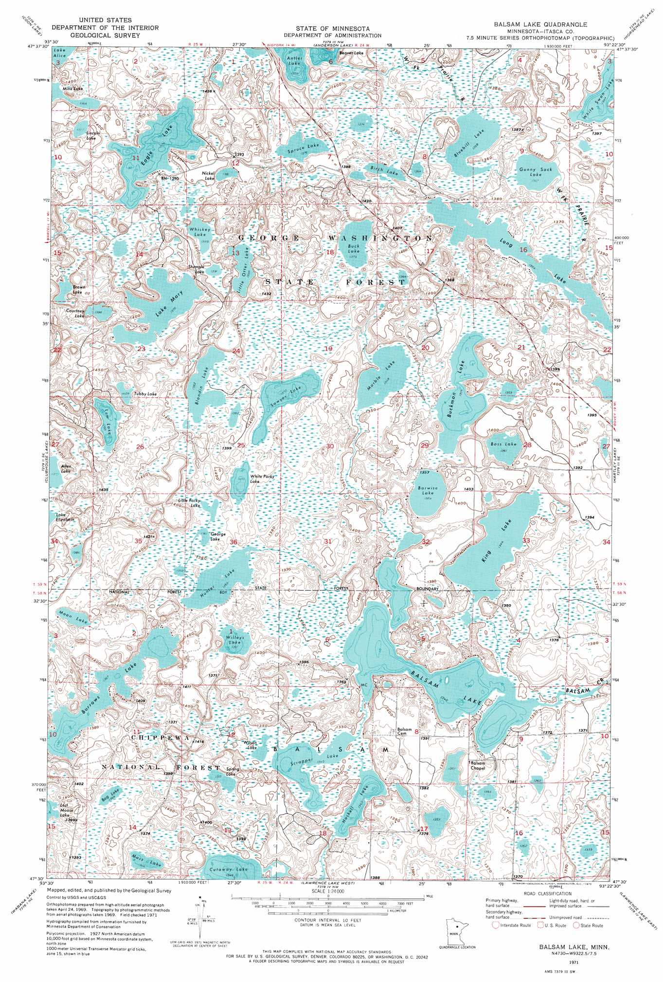
USGS Topo Quad 47093e4 - 1:24,000 scale
| Topo Map Name: | Balsam Lake |
| USGS Topo Quad ID: | 47093e4 |
| Print Size: | ca. 21 1/4" wide x 27" high |
| Southeast Coordinates: | 47.5° N latitude / 93.375° W longitude |
| Map Center Coordinates: | 47.5625° N latitude / 93.4375° W longitude |
| U.S. State: | MN |
| Filename: | o47093e4.jpg |
| Download Map JPG Image: | Balsam Lake topo map 1:24,000 scale |
| Map Type: | Topographic |
| Topo Series: | 7.5´ |
| Map Scale: | 1:24,000 |
| Source of Map Images: | United States Geological Survey (USGS) |
| Alternate Map Versions: |
Balsam Lake MN 1971, updated 1973 Download PDF Buy paper map Balsam Lake MN 1996, updated 1998 Download PDF Buy paper map Balsam Lake MN 2011 Download PDF Buy paper map Balsam Lake MN 2013 Download PDF Buy paper map Balsam Lake MN 2016 Download PDF Buy paper map |
| FStopo: | US Forest Service topo Balsam Lake is available: Download FStopo PDF Download FStopo TIF |
1:24,000 Topo Quads surrounding Balsam Lake
Effie |
Effie Se |
Deer Lake West |
Deer Lake East |
Togo |
Bigfork |
Coon Lake |
Anderson Lake |
Horsehead Lake |
Sherry Lake |
Marcell |
Clubhouse Lake |
Balsam Lake |
Hartley Lake |
O'Leary Lake |
Little Bowstring Lake |
Wabana Lake |
Lawrence Lake West |
Lawrence Lake East |
Nashwauk |
Cohasset West |
Cohasset East |
Bovey |
Calumet |
Pengilly |
> Back to 47093e1 at 1:100,000 scale
> Back to 47092a1 at 1:250,000 scale
> Back to U.S. Topo Maps home
Balsam Lake topo map: Gazetteer
Balsam Lake: Airports
Bolduc Seaplane Base elevation 413m 1354′Balsam Lake: Dams
Balsam Lake Dam elevation 419m 1374′King Lake Group Lake Outlet Structure Dam elevation 413m 1354′
Balsam Lake: Forests
Marcell Experimental Forest elevation 428m 1404′Marcell Experimental Forest elevation 422m 1384′
Balsam Lake: Lakes
Balsam Lake elevation 409m 1341′Barwise Lake elevation 413m 1354′
Bass Lake elevation 415m 1361′
Beaver Lake elevation 420m 1377′
Birch Lake elevation 416m 1364′
Blandin Lake elevation 421m 1381′
Bluebill Lake elevation 414m 1358′
Bog Lake elevation 416m 1364′
Brown Lake elevation 422m 1384′
Buck Lake elevation 421m 1381′
Buckman Lake elevation 414m 1358′
Burrows Lake elevation 417m 1368′
Courtney Lake elevation 426m 1397′
Eagle Lake elevation 419m 1374′
George Lake elevation 415m 1361′
Gunny Sack Lake elevation 414m 1358′
Haskell Lake elevation 409m 1341′
Hunter Lake elevation 414m 1358′
King Lake elevation 410m 1345′
Lake Mary elevation 420m 1377′
Lincoln Lake elevation 420m 1377′
Little Otter Lake elevation 426m 1397′
Little Porky Lake elevation 416m 1364′
Long Lake elevation 413m 1354′
Lum Lake elevation 425m 1394′
Marble Lake elevation 411m 1348′
Moon Lake elevation 432m 1417′
Moss Lake elevation 414m 1358′
Nickel Lake elevation 421m 1381′
Sawyer Lake elevation 418m 1371′
Scrapper Lake elevation 409m 1341′
Spring Lake elevation 418m 1371′
Spruce Lake elevation 420m 1377′
Stumple Lake elevation 424m 1391′
Tubby Lake elevation 430m 1410′
Whiskey Lake elevation 424m 1391′
White Porky Lake elevation 418m 1371′
White Swan Lake elevation 423m 1387′
Willeys Lake elevation 415m 1361′
Wilson Lake elevation 409m 1341′
Balsam Lake: Reservoirs
Balsam Lake elevation 419m 1374′Balsam Lake digital topo map on disk
Buy this Balsam Lake topo map showing relief, roads, GPS coordinates and other geographical features, as a high-resolution digital map file on DVD: