Mantrap Lake Topo Map Minnesota
To zoom in, hover over the map of Mantrap Lake
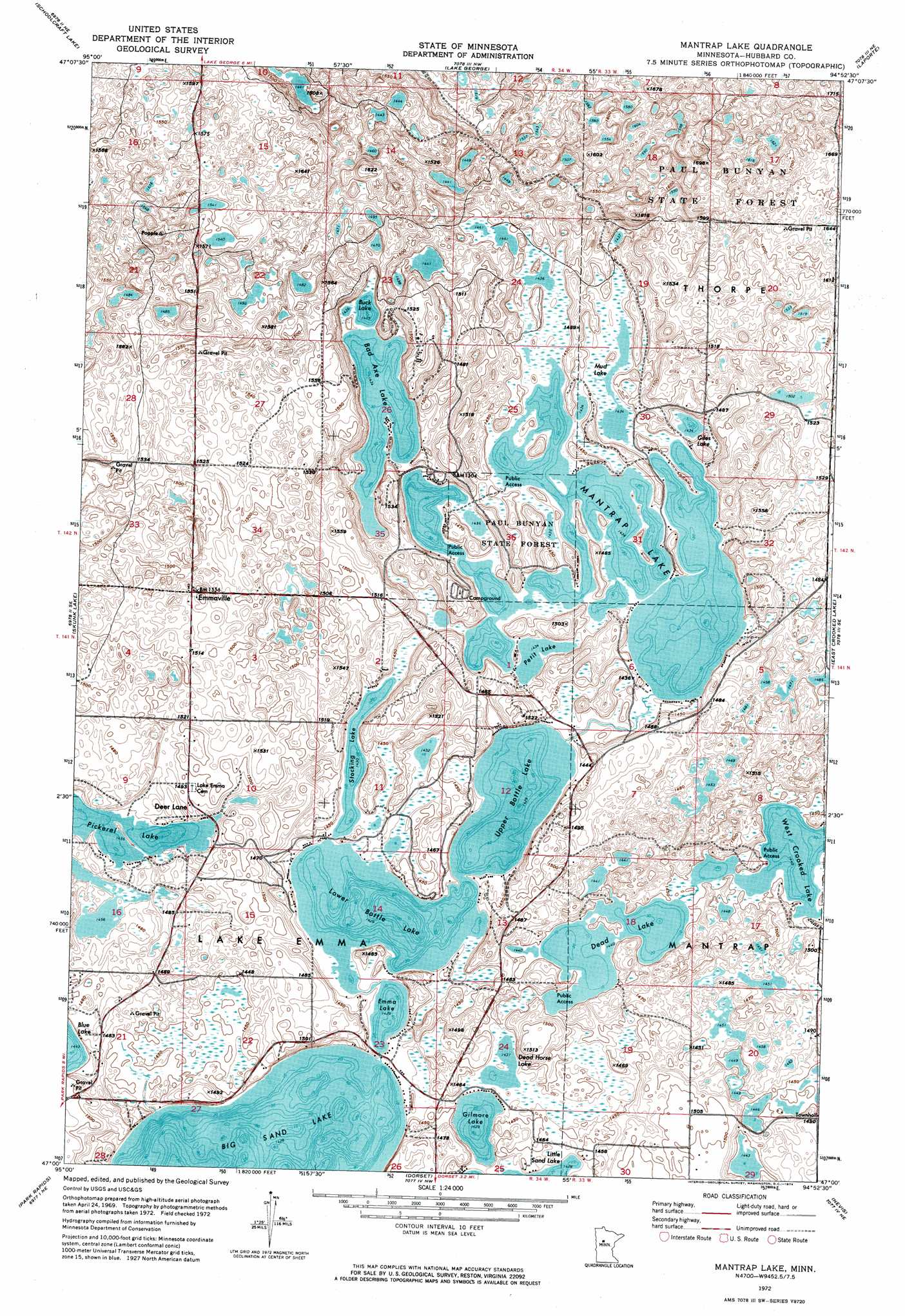
USGS Topo Quad 47094a8 - 1:24,000 scale
| Topo Map Name: | Mantrap Lake |
| USGS Topo Quad ID: | 47094a8 |
| Print Size: | ca. 21 1/4" wide x 27" high |
| Southeast Coordinates: | 47° N latitude / 94.875° W longitude |
| Map Center Coordinates: | 47.0625° N latitude / 94.9375° W longitude |
| U.S. State: | MN |
| Filename: | p47094a8.jpg |
| Download Map JPG Image: | Mantrap Lake topo map 1:24,000 scale |
| Map Type: | Orthophoto |
| Topo Series: | 7.5´ |
| Map Scale: | 1:24,000 |
| Source of Map Images: | United States Geological Survey (USGS) |
| Alternate Map Versions: |
Mantrap Lake MN 1972, updated 1974 Download PDF Buy paper map Mantrap Lake MN 1972, updated 1991 Download PDF Buy paper map Mantrap Lake MN 2010 Download PDF Buy paper map Mantrap Lake MN 2013 Download PDF Buy paper map Mantrap Lake MN 2016 Download PDF Buy paper map |
1:24,000 Topo Quads surrounding Mantrap Lake
La Salle Lake |
Lake Hattie |
Frontenac Lake |
Guthrie |
Steamboat Lake |
Lake Itasca |
Schoolcraft Lake |
Lake George |
Laporte |
Benedict |
Two Inlets |
Skunk Lake |
Mantrap Lake |
East Crooked Lake |
Akeley |
Park Rapids Nw |
Park Rapids |
Dorset |
Nevis |
Crystal Lake |
Park Rapids Sw |
Menahga |
Huntersville |
First Crow Wing Lake |
Oshawa |
> Back to 47094a1 at 1:100,000 scale
> Back to 47094a1 at 1:250,000 scale
> Back to U.S. Topo Maps home
Mantrap Lake topo map: Gazetteer
Mantrap Lake: Lakes
Bad Axe Lake elevation 437m 1433′Big Sand Lake elevation 436m 1430′
Buck Lake elevation 437m 1433′
Dead Horse Lake elevation 436m 1430′
Emma Lake elevation 436m 1430′
Giles Lake elevation 438m 1437′
Gilmore Lake elevation 436m 1430′
Lower Bottle Lake elevation 436m 1430′
Mantrap Lake elevation 437m 1433′
Mud Lake elevation 437m 1433′
Objibway Lake elevation 439m 1440′
Ojibway Lake elevation 439m 1440′
Petit Lake elevation 437m 1433′
Pickerel Lake elevation 444m 1456′
Stocking Lake elevation 436m 1430′
Upper Bottle Lake elevation 436m 1430′
West Crooked Lake elevation 439m 1440′
Mantrap Lake: Populated Places
Deer Lane elevation 449m 1473′Emmaville elevation 474m 1555′
Mantrap Lake: Post Offices
Emmaville Post Office (historical) elevation 474m 1555′Mantrap Post Office (historical) elevation 438m 1437′
Oran Post Office (historical) elevation 479m 1571′
Mantrap Lake digital topo map on disk
Buy this Mantrap Lake topo map showing relief, roads, GPS coordinates and other geographical features, as a high-resolution digital map file on DVD: