Max Topo Map Minnesota
To zoom in, hover over the map of Max
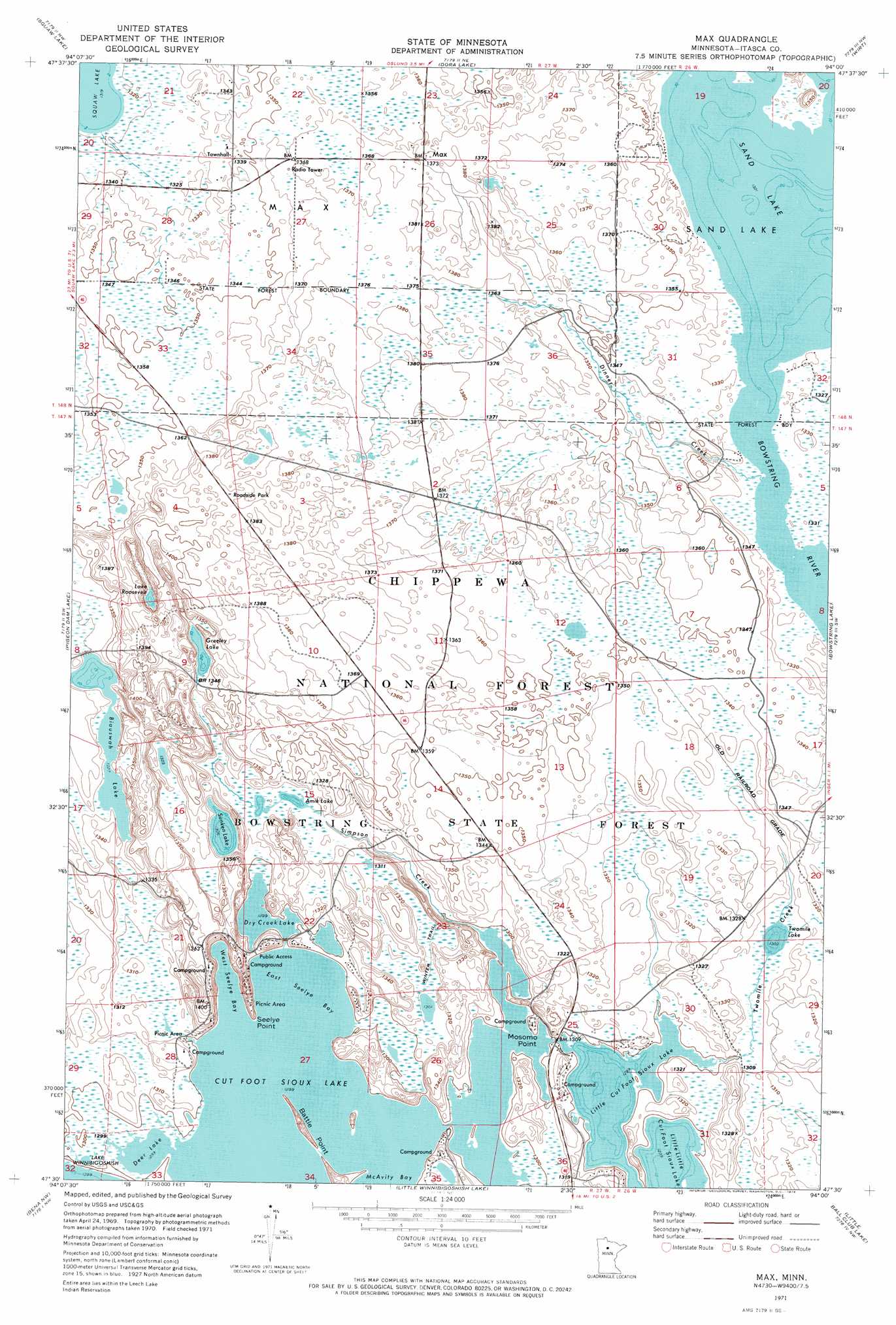
USGS Topo Quad 47094e1 - 1:24,000 scale
| Topo Map Name: | Max |
| USGS Topo Quad ID: | 47094e1 |
| Print Size: | ca. 21 1/4" wide x 27" high |
| Southeast Coordinates: | 47.5° N latitude / 94° W longitude |
| Map Center Coordinates: | 47.5625° N latitude / 94.0625° W longitude |
| U.S. State: | MN |
| Filename: | p47094e1.jpg |
| Download Map JPG Image: | Max topo map 1:24,000 scale |
| Map Type: | Orthophoto |
| Topo Series: | 7.5´ |
| Map Scale: | 1:24,000 |
| Source of Map Images: | United States Geological Survey (USGS) |
| Alternate Map Versions: |
Max MN 1971, updated 1974 Download PDF Buy paper map Max MN 1996, updated 1998 Download PDF Buy paper map Max MN 2011 Download PDF Buy paper map Max MN 2013 Download PDF Buy paper map Max MN 2016 Download PDF Buy paper map |
| FStopo: | US Forest Service topo Max is available: Download FStopo PDF Download FStopo TIF |
1:24,000 Topo Quads surrounding Max
Northome South |
Elmwood Island |
Coddington Lake |
Pomroy |
Wildwood Se |
Alvwood |
Squaw Lake |
Dora Lake |
Wirt |
Spring Lake |
Dixon Lake |
Pigeon Dam Lake |
Max |
Bowstring Lake |
Jessie Lake |
Raven Lake |
Bena Nw |
Little Winnibigoshish Lake |
Little Ball Club Lake |
Deer River Ne |
Portage Lake |
Bena |
Nushka Lake |
Ball Club |
Deer River |
> Back to 47094e1 at 1:100,000 scale
> Back to 47094a1 at 1:250,000 scale
> Back to U.S. Topo Maps home
Max topo map: Gazetteer
Max: Bays
East Seelye Bay elevation 396m 1299′West Seelye Bay elevation 396m 1299′
Max: Capes
Battle Point elevation 402m 1318′Mosomo Point elevation 397m 1302′
Seelye Point elevation 407m 1335′
Max: Dams
Amik Lake Dam elevation 410m 1345′Max: Forests
Cutfoot Experimental Forest elevation 415m 1361′Max: Lakes
Amik Lake elevation 401m 1315′Biauswah Lake elevation 405m 1328′
Cut Foot Sioux Lake elevation 396m 1299′
Deer Lake elevation 396m 1299′
Dry Creek Lake elevation 396m 1299′
Greeley Lake elevation 407m 1335′
Lake Roosevelt elevation 407m 1335′
Little Cut Foot Sioux Lake elevation 396m 1299′
Sand Lake elevation 403m 1322′
Sunken Lake elevation 398m 1305′
Twomile Lake elevation 397m 1302′
Max: Populated Places
Max elevation 418m 1371′Wiiams Narrows Resort and Mobile Home Court elevation 398m 1305′
Max: Post Offices
Max Post Office elevation 418m 1371′Max: Reservoirs
Amik Impoundment elevation 401m 1315′Amik Lake elevation 410m 1345′
Twomile Impoundment elevation 398m 1305′
Max: Streams
Dinner Creek elevation 403m 1322′Simpson Creek elevation 396m 1299′
Twomile Creek elevation 396m 1299′
Max: Trails
Cutfoot Sioux National Recreation Trail elevation 415m 1361′Simpson Creek Trail System elevation 397m 1302′
Turtle Mound Trail elevation 399m 1309′
Max digital topo map on disk
Buy this Max topo map showing relief, roads, GPS coordinates and other geographical features, as a high-resolution digital map file on DVD: