Pigeon Dam Lake Topo Map Minnesota
To zoom in, hover over the map of Pigeon Dam Lake
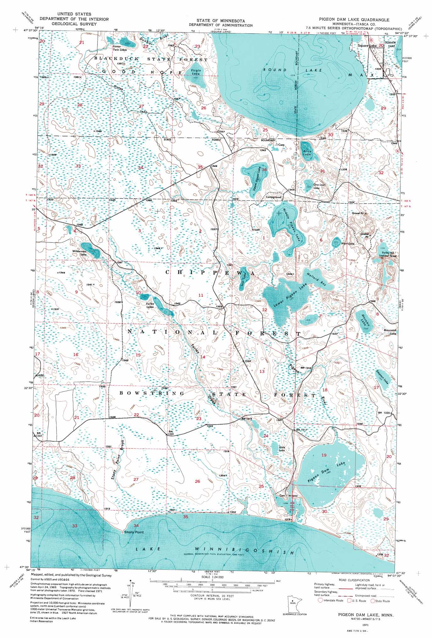
USGS Topo Quad 47094e2 - 1:24,000 scale
| Topo Map Name: | Pigeon Dam Lake |
| USGS Topo Quad ID: | 47094e2 |
| Print Size: | ca. 21 1/4" wide x 27" high |
| Southeast Coordinates: | 47.5° N latitude / 94.125° W longitude |
| Map Center Coordinates: | 47.5625° N latitude / 94.1875° W longitude |
| U.S. State: | MN |
| Filename: | p47094e2.jpg |
| Download Map JPG Image: | Pigeon Dam Lake topo map 1:24,000 scale |
| Map Type: | Orthophoto |
| Topo Series: | 7.5´ |
| Map Scale: | 1:24,000 |
| Source of Map Images: | United States Geological Survey (USGS) |
| Alternate Map Versions: |
Pigeon Dam Lake MN 1971, updated 1974 Download PDF Buy paper map Pigeon Dam Lake MN 1996, updated 1998 Download PDF Buy paper map Pigeon Dam Lake MN 2011 Download PDF Buy paper map Pigeon Dam Lake MN 2013 Download PDF Buy paper map Pigeon Dam Lake MN 2016 Download PDF Buy paper map |
| FStopo: | US Forest Service topo Pigeon Dam Lake is available: Download FStopo PDF Download FStopo TIF |
1:24,000 Topo Quads surrounding Pigeon Dam Lake
Funkley |
Northome South |
Elmwood Island |
Coddington Lake |
Pomroy |
Decker Lake |
Alvwood |
Squaw Lake |
Dora Lake |
Wirt |
Gimmer Lake |
Dixon Lake |
Pigeon Dam Lake |
Max |
Bowstring Lake |
Pennington |
Raven Lake |
Bena Nw |
Little Winnibigoshish Lake |
Little Ball Club Lake |
Sucker Lakes |
Portage Lake |
Bena |
Nushka Lake |
Ball Club |
> Back to 47094e1 at 1:100,000 scale
> Back to 47094a1 at 1:250,000 scale
> Back to U.S. Topo Maps home
Pigeon Dam Lake topo map: Gazetteer
Pigeon Dam Lake: Bays
Mallard Bay elevation 399m 1309′Pigeon Dam Lake: Capes
Stony Point elevation 397m 1302′Pigeon Dam Lake: Dams
Pigeon Dam Lake elevation 396m 1299′Pigeon Dam Lake: Lakes
Alice Lake elevation 402m 1318′Farley Lakes elevation 404m 1325′
Hale Lake elevation 401m 1315′
Lost Lake elevation 401m 1315′
Lower Pigeon Lake elevation 399m 1309′
Lower Twin Lakes elevation 404m 1325′
Middle Pigeon Lake elevation 400m 1312′
Mosomo Lake elevation 404m 1325′
One Loaf Lake elevation 407m 1335′
Pigeon Dam Lake elevation 396m 1299′
Round Lake elevation 402m 1318′
Simpson Lake elevation 404m 1325′
Upper Pigeon Lake elevation 400m 1312′
Virgin Lake elevation 406m 1332′
Wart Lake elevation 400m 1312′
Wilderness Lake elevation 405m 1328′
Pigeon Dam Lake: Parks
Lower Pigeon Lake Game Refuge elevation 400m 1312′Pigeon River Flowage Game Refuge elevation 396m 1299′
Pigeon Dam Lake: Reservoirs
Pigeon River Impoundment elevation 398m 1305′Pigeon Dam Lake: Streams
Dunbar River elevation 405m 1328′Farley Creek elevation 396m 1299′
Pigeon River elevation 396m 1299′
Stony Point Brook elevation 399m 1309′
Pigeon Dam Lake digital topo map on disk
Buy this Pigeon Dam Lake topo map showing relief, roads, GPS coordinates and other geographical features, as a high-resolution digital map file on DVD: