Jim Lake Topo Map North Dakota
To zoom in, hover over the map of Jim Lake
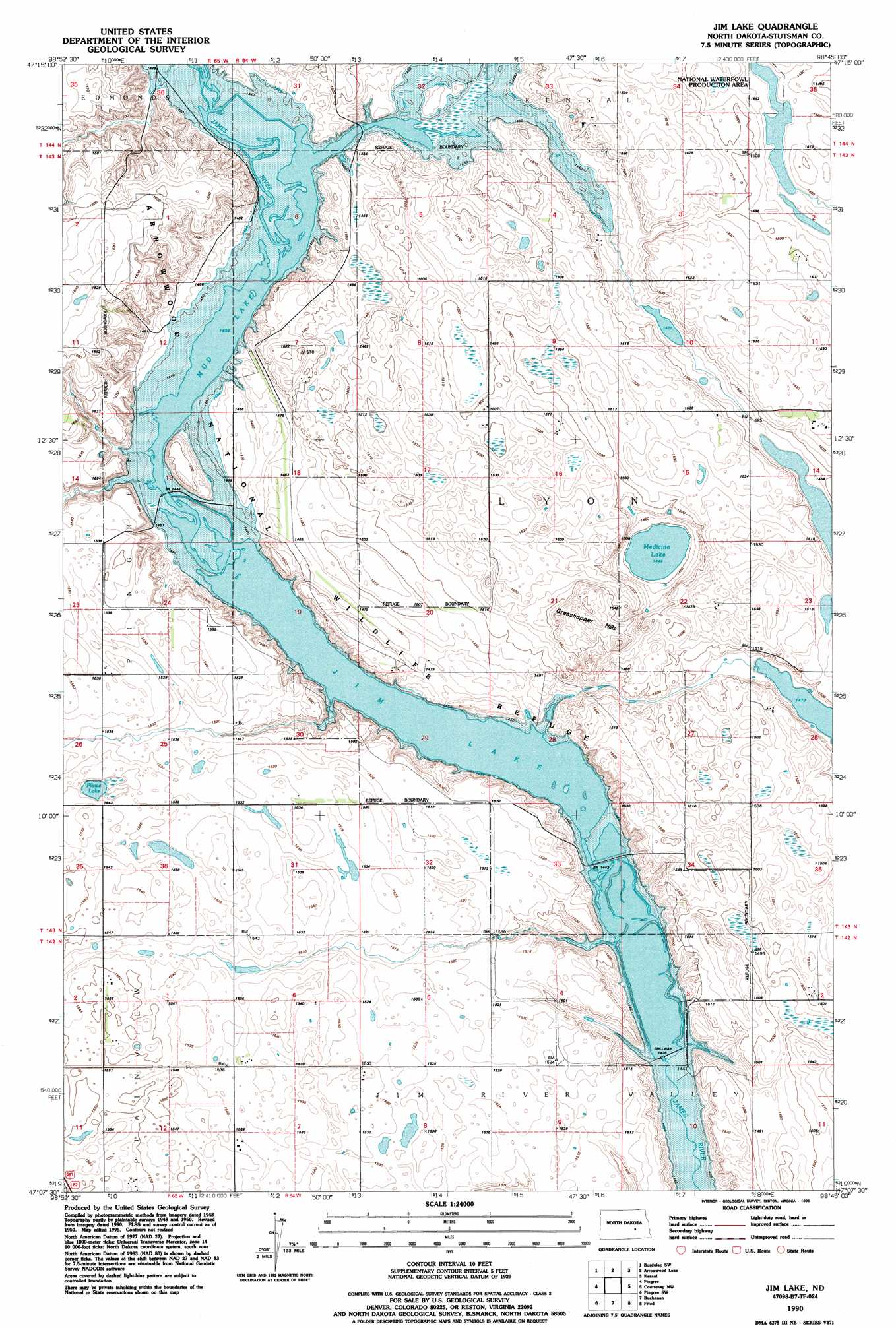
USGS Topo Quad 47098b7 - 1:24,000 scale
| Topo Map Name: | Jim Lake |
| USGS Topo Quad ID: | 47098b7 |
| Print Size: | ca. 21 1/4" wide x 27" high |
| Southeast Coordinates: | 47.125° N latitude / 98.75° W longitude |
| Map Center Coordinates: | 47.1875° N latitude / 98.8125° W longitude |
| U.S. State: | ND |
| Filename: | O47098B7.jpg |
| Download Map JPG Image: | Jim Lake topo map 1:24,000 scale |
| Map Type: | Topographic |
| Topo Series: | 7.5´ |
| Map Scale: | 1:24,000 |
| Source of Map Images: | United States Geological Survey (USGS) |
| Alternate Map Versions: |
Jim Lake ND 1952, updated 1952 Download PDF Buy paper map Jim Lake ND 1990, updated 1995 Download PDF Buy paper map Jim Lake ND 2011 Download PDF Buy paper map Jim Lake ND 2014 Download PDF Buy paper map |
1:24,000 Topo Quads surrounding Jim Lake
Carrington East |
Bordulac |
Bordulac Ne |
Kensal Nw |
Glenfield |
Melville |
Bordulac Sw |
Arrowwood Lake |
Kensal |
Kensal Se |
Vashti |
Pingree |
Jim Lake |
Courtenay Nw |
Courtenay |
Goldwin Se |
Pingree Sw |
Buchanan |
Fried |
Spiritwood Lake |
Cleveland |
Eldridge Nw |
Eldridge |
Jamestown |
Bloom |
> Back to 47098a1 at 1:100,000 scale
> Back to 47098a1 at 1:250,000 scale
> Back to U.S. Topo Maps home
Jim Lake topo map: Gazetteer
Jim Lake: Dams
Depuy Dam elevation 446m 1463′Jim Dam elevation 467m 1532′
Jim Lake: Lakes
Medicine Lake elevation 442m 1450′Plowe Lake elevation 467m 1532′
Jim Lake: Parks
Arrowwood National Wildlife Refuge elevation 492m 1614′Jim Lake: Post Offices
Elsler Post Office (historical) elevation 464m 1522′Jim Lake: Ranges
Grasshopper Hills elevation 485m 1591′Jim Lake: Reservoirs
Depuy Dam Lake elevation 446m 1463′Jim Lake elevation 438m 1437′
Jim Reservoir elevation 467m 1532′
Mud Lake elevation 438m 1437′
Jim Lake: Streams
Stony Brook elevation 438m 1437′Jim Lake digital topo map on disk
Buy this Jim Lake topo map showing relief, roads, GPS coordinates and other geographical features, as a high-resolution digital map file on DVD:
Eastern North Dakota & Eastern South Dakota
Buy digital topo maps: Eastern North Dakota & Eastern South Dakota