Sanish Topo Map North Dakota
To zoom in, hover over the map of Sanish
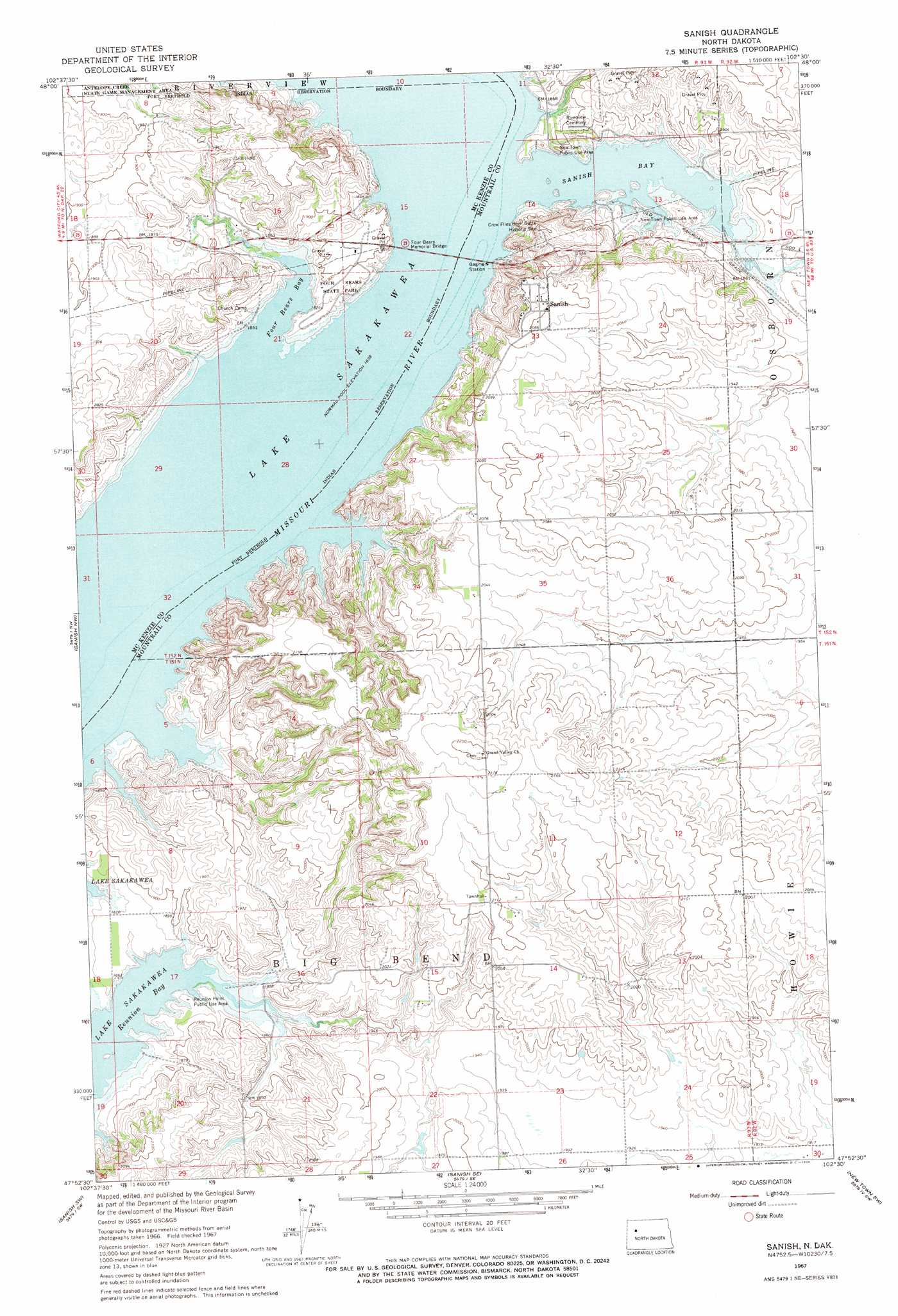
USGS Topo Quad 47102h5 - 1:24,000 scale
| Topo Map Name: | Sanish |
| USGS Topo Quad ID: | 47102h5 |
| Print Size: | ca. 21 1/4" wide x 27" high |
| Southeast Coordinates: | 47.875° N latitude / 102.5° W longitude |
| Map Center Coordinates: | 47.9375° N latitude / 102.5625° W longitude |
| U.S. State: | ND |
| Filename: | O47102H5.jpg |
| Download Map JPG Image: | Sanish topo map 1:24,000 scale |
| Map Type: | Topographic |
| Topo Series: | 7.5´ |
| Map Scale: | 1:24,000 |
| Source of Map Images: | United States Geological Survey (USGS) |
| Alternate Map Versions: |
Sanish ND 1967, updated 1969 Download PDF Buy paper map Sanish ND 1967, updated 1969 Download PDF Buy paper map Sanish ND 2011 Download PDF Buy paper map Sanish ND 2014 Download PDF Buy paper map |
1:24,000 Topo Quads surrounding Sanish
Charlson Ne |
Rat Lake |
Robinson Lake |
Sikes Dam |
Belden |
Charlson |
Rat Lake Sw |
Rat Lake Se |
Belden Sw |
Belden Se |
Blue Buttes |
Sanish Nw |
Sanish |
New Town |
Shell Creek Bay |
Blue Buttes Se |
Sanish Sw |
Sanish Se |
New Town Sw |
New Town Se |
Figure 4 Ranch |
Mandaree |
Mandaree Ne |
String Buttes |
Saddle Butte |
> Back to 47102e1 at 1:100,000 scale
> Back to 47102a1 at 1:250,000 scale
> Back to U.S. Topo Maps home
Sanish topo map: Gazetteer
Sanish: Bays
Four Bears Bay elevation 561m 1840′Reunion Bay elevation 561m 1840′
Sanish Bay elevation 561m 1840′
Sanish: Bridges
Four Bears Memorial Bridge elevation 561m 1840′Sanish: Islands
Knifer Towhead (historical) elevation 561m 1840′Sanish: Parks
Crow Flies High Butte Historic Site elevation 636m 2086′Four Bears Park elevation 576m 1889′
New Town Public Use Area elevation 569m 1866′
Reunion Point Public Use Area elevation 568m 1863′
Sanish: Populated Places
Four Bears Village elevation 596m 1955′Sanish elevation 646m 2119′
Sanish digital topo map on disk
Buy this Sanish topo map showing relief, roads, GPS coordinates and other geographical features, as a high-resolution digital map file on DVD:
Eastern Montana & Western North Dakota
Buy digital topo maps: Eastern Montana & Western North Dakota