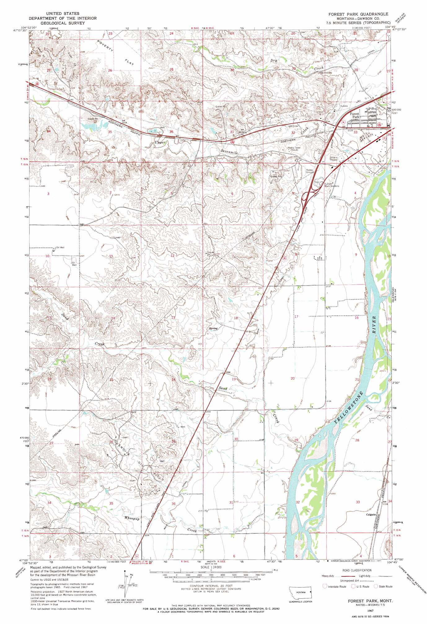
Forest Park Topo Map Montana
To zoom in, hover over the map of Forest Park
USGS Topo Quad 47104a7 - 1:24,000 scale
| Topo Map Name: | Forest Park |
| USGS Topo Quad ID: | 47104a7 |
| Print Size: | ca. 21 1/4" wide x 27" high |
| Southeast Coordinates: | 47° N latitude / 104.75° W longitude |
| Map Center Coordinates: | 47.0625° N latitude / 104.8125° W longitude |
| U.S. State: | MT |
| Filename: | o47104a7.jpg |
| Download Map JPG Image: | Forest Park topo map 1:24,000 scale |
| Map Type: | Topographic |
| Topo Series: | 7.5´ |
| Map Scale: | 1:24,000 |
| Source of Map Images: | United States Geological Survey (USGS) |
| Alternate Map Versions: |
Forest Park MT 1967, updated 1971 Download PDF Buy paper map Forest Park MT 2011 Download PDF Buy paper map Forest Park MT 2014 Download PDF Buy paper map |
1:24,000 Topo Quads surrounding Forest Park
Johnson Reservoir |
Stinking Coulee |
Morgan Creek School |
Kolberg Ranch |
Intake |
Woodrow |
Poverty Flat West |
Poverty Flat East |
Stipek |
Belle Prairie |
Upper Cracker Box School |
Pleasant View |
Forest Park |
Glendive |
Allard |
Fallon Ne |
Marsh |
Hoyt |
Upper Magpie Reservoir |
Twin Forks Reservoir |
Fallon |
Marsh Sw |
Simons Butte |
Graveyard Hill Sw |
Graveyard Hill |
> Back to 47104a1 at 1:100,000 scale
> Back to 47104a1 at 1:250,000 scale
> Back to U.S. Topo Maps home
Forest Park topo map: Gazetteer
Forest Park: Canals
Main Siphon Canal elevation 655m 2148′Forest Park: Crossings
Interchange 204 elevation 677m 2221′Interchange 206 elevation 672m 2204′
Interchange 210 elevation 659m 2162′
Interchange 211 elevation 651m 2135′
Forest Park: Oilfields
Glendive Oil Field elevation 714m 2342′Forest Park: Populated Places
Colgate elevation 644m 2112′Forest Park elevation 643m 2109′
Landtsheim (historical) elevation 709m 2326′
Forest Park: Streams
Sand Creek elevation 627m 2057′Sand Creek elevation 629m 2063′
Upper Sevenmile Creek elevation 625m 2050′
Whoopup Creek elevation 629m 2063′
Forest Park: Wells
14N54E24ADA_01 Well elevation 651m 2135′14N55E06ADD_01 Well elevation 652m 2139′
14N55E06BBBB01 Well elevation 663m 2175′
14N55E19BDA_01 Well elevation 664m 2178′
14N55E30CDB_02 Well elevation 652m 2139′
15N54E02DADB01 Well elevation 754m 2473′
15N54E22CDBD01 Well elevation 753m 2470′
15N54E23DDCC01 Well elevation 734m 2408′
15N54E25DAA_01 Well elevation 664m 2178′
15N54E25DDA_01 Well elevation 665m 2181′
15N54E26CABD01 Well elevation 738m 2421′
15N54E34CAAB01 Well elevation 695m 2280′
15N54E34DDCA01 Well elevation 726m 2381′
15N54E36AAC_01 Well elevation 663m 2175′
15N54E36AAC_02 Well elevation 663m 2175′
15N54E36ACA_01 Well elevation 663m 2175′
15N54E36ACA_02 Well elevation 670m 2198′
15N54E36CAA_01 Well elevation 668m 2191′
15N54E36CAD_01 Well elevation 650m 2132′
15N55E04CAA_01 Well elevation 648m 2125′
15N55E04CBB_01 Well elevation 659m 2162′
15N55E08ABA_01 Well elevation 657m 2155′
15N55E08ACD_01 Well elevation 651m 2135′
15N55E08ADD_01 Well elevation 660m 2165′
15N55E08DCC_01 Well elevation 652m 2139′
15N55E08DDD_01 Well elevation 648m 2125′
15N55E09BBB_01 Well elevation 646m 2119′
15N55E09CCD_01 Well elevation 644m 2112′
15N55E13CBB_01 Well elevation 656m 2152′
15N55E16BAB_01 Well elevation 644m 2112′
15N55E16BAB_02 Well elevation 644m 2112′
15N55E16BAB_03 Well elevation 644m 2112′
15N55E16BAB_04 Well elevation 645m 2116′
15N55E16BAC_01 Well elevation 648m 2125′
15N55E16BBC_01 Well elevation 645m 2116′
15N55E16BBD_01 Well elevation 645m 2116′
15N55E16BDA_01 Well elevation 645m 2116′
15N55E16BDA_02 Well elevation 644m 2112′
15N55E16CAA_01 Well elevation 644m 2112′
15N55E16CAD_01 Well elevation 646m 2119′
15N55E16CBB_01 Well elevation 649m 2129′
15N55E16CBB_02 Well elevation 646m 2119′
15N55E16CBD_01 Well elevation 648m 2125′
15N55E16CCD_02 Well elevation 644m 2112′
15N55E16CDD_01 Well elevation 644m 2112′
15N55E16DCB_01 Well elevation 651m 2135′
15N55E17AAC_01 Well elevation 649m 2129′
15N55E17ADD_01 Well elevation 654m 2145′
15N55E17BACB01 Well elevation 659m 2162′
15N55E17BDD_01 Well elevation 666m 2185′
15N55E17CBB_01 Well elevation 648m 2125′
15N55E17DAA_02 Well elevation 648m 2125′
15N55E17DAA_03 Well elevation 648m 2125′
15N55E17DAA_04 Well elevation 648m 2125′
15N55E17DAA_05 Well elevation 649m 2129′
15N55E17DAD_01 Well elevation 670m 2198′
15N55E18ADD_01 Well elevation 667m 2188′
15N55E18DAB_01 Well elevation 660m 2165′
15N55E18DAD_01 Well elevation 667m 2188′
15N55E18DDC_01 Well elevation 657m 2155′
15N55E19DAA_01 Well elevation 674m 2211′
15N55E19DAB_01 Well elevation 649m 2129′
15N55E20AAA_01 Well elevation 647m 2122′
15N55E20ADD_01 Well elevation 653m 2142′
15N55E20CAA_01 Well elevation 652m 2139′
15N55E20CCD_01 Well elevation 650m 2132′
15N55E20CDD_01 Well elevation 649m 2129′
15N55E20DDD_01 Well elevation 629m 2063′
15N55E21DBC_01 Well elevation 646m 2119′
15N55E22BBA_01 Well elevation 652m 2139′
15N55E29BBAB01 Well elevation 659m 2162′
15N55E30BDC_01 Well elevation 660m 2165′
15N55E30BDC_02 Well elevation 652m 2139′
15N55E30CDA_01 Well elevation 654m 2145′
15N55E30DBA_01 Well elevation 646m 2119′
15N55E30DDC_01 Well elevation 648m 2125′
15N55E30DDD_01 Well elevation 647m 2122′
15N55E31AAB_01 Well elevation 649m 2129′
15N55E31AAC_01 Well elevation 650m 2132′
15N55E31ABD_02 Well elevation 650m 2132′
15N55E31ACA_01 Well elevation 642m 2106′
15N55E31ADA_01 Well elevation 657m 2155′
15N55E31BCB_01 Well elevation 655m 2148′
15N55E31BDB_01 Well elevation 653m 2142′
15N55E31DAA_01 Well elevation 643m 2109′
15N55E31DAA_02 Well elevation 635m 2083′
15N55E32BDB_01 Well elevation 638m 2093′
15N55E33BBAC01 Well elevation 632m 2073′
16N55E28DCA_01 Well elevation 645m 2116′
16N55E28DDCD01 Well elevation 643m 2109′
16N55E30BDAB01 Well elevation 690m 2263′
Forest Park digital topo map on disk
Buy this Forest Park topo map showing relief, roads, GPS coordinates and other geographical features, as a high-resolution digital map file on DVD:
Eastern Montana & Western North Dakota
Buy digital topo maps: Eastern Montana & Western North Dakota