Mccone Heights Topo Map Montana
To zoom in, hover over the map of Mccone Heights
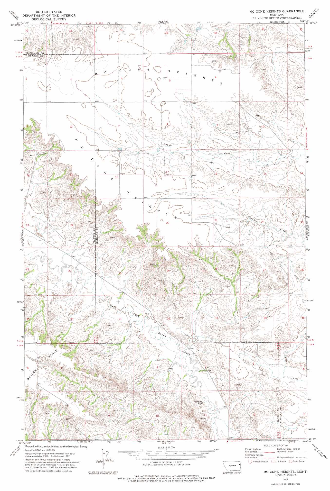
USGS Topo Quad 47104e5 - 1:24,000 scale
| Topo Map Name: | Mccone Heights |
| USGS Topo Quad ID: | 47104e5 |
| Print Size: | ca. 21 1/4" wide x 27" high |
| Southeast Coordinates: | 47.5° N latitude / 104.5° W longitude |
| Map Center Coordinates: | 47.5625° N latitude / 104.5625° W longitude |
| U.S. State: | MT |
| Filename: | o47104e5.jpg |
| Download Map JPG Image: | Mccone Heights topo map 1:24,000 scale |
| Map Type: | Topographic |
| Topo Series: | 7.5´ |
| Map Scale: | 1:24,000 |
| Source of Map Images: | United States Geological Survey (USGS) |
| Alternate Map Versions: |
Mc Cone Heights MT 1972, updated 1975 Download PDF Buy paper map McCone Heights MT 2011 Download PDF Buy paper map McCone Heights MT 2014 Download PDF Buy paper map |
1:24,000 Topo Quads surrounding Mccone Heights
Carda Coulee |
Three Buttes Creek West |
Three Buttes Creek East |
Girard |
Brorson |
Enid |
Fox Lake |
Lambert |
Crane Nw |
Crane Ne |
Enid Se |
Butler Table |
Mccone Heights |
Larson School |
Crane |
Red Top |
Intake Nw |
Allard Ranch |
Knife River Mine |
Savage |
Morgan Creek School |
Kolberg Ranch |
Intake |
Savage Sw |
Savage Se |
> Back to 47104e1 at 1:100,000 scale
> Back to 47104a1 at 1:250,000 scale
> Back to U.S. Topo Maps home
Mccone Heights topo map: Gazetteer
Mccone Heights: Pillars
Chimney Rock elevation 689m 2260′Mccone Heights: Plains
McCone Heights elevation 826m 2709′Mccone Heights: Springs
20N56E05AACB01 Spring elevation 769m 2522′Mccone Heights: Wells
20N56E01DBCC01 Well elevation 723m 2372′20N56E02DBBC01 Well elevation 697m 2286′
20N56E03DBAA01 Well elevation 700m 2296′
20N56E04DDDA01 Well elevation 748m 2454′
20N56E05BCAD01 Well elevation 823m 2700′
20N56E08ABCC01 Well elevation 828m 2716′
20N56E08DDCD01 Well elevation 762m 2500′
20N56E08DDCD02 Well elevation 762m 2500′
20N56E09ADCB01 Well elevation 738m 2421′
20N56E12BCBC01 Well elevation 694m 2276′
21N55E02AADA01 Well elevation 829m 2719′
21N55E11ADAC01 Well elevation 823m 2700′
21N55E14ABAD01 Well elevation 762m 2500′
21N55E25DCCA01 Well elevation 713m 2339′
21N56E10BDBA01 Well elevation 789m 2588′
21N56E20CABC01 Well elevation 825m 2706′
21N56E21DBAD01 Well elevation 806m 2644′
21N56E28ADDC01 Well elevation 759m 2490′
21N56E32DDAC01 Well elevation 696m 2283′
21N56E33BCAD01 Well elevation 706m 2316′
21N56E34BDBD01 Well elevation 742m 2434′
22N56E33CCCC01 Well elevation 819m 2687′
Mccone Heights digital topo map on disk
Buy this Mccone Heights topo map showing relief, roads, GPS coordinates and other geographical features, as a high-resolution digital map file on DVD:
Eastern Montana & Western North Dakota
Buy digital topo maps: Eastern Montana & Western North Dakota