Watkins Se Topo Map Montana
To zoom in, hover over the map of Watkins Se
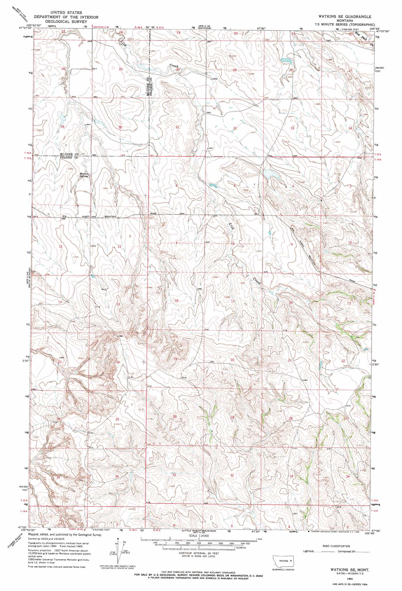
USGS Topo Quad 47105a7 - 1:24,000 scale
| Topo Map Name: | Watkins Se |
| USGS Topo Quad ID: | 47105a7 |
| Print Size: | ca. 21 1/4" wide x 27" high |
| Southeast Coordinates: | 47° N latitude / 105.75° W longitude |
| Map Center Coordinates: | 47.0625° N latitude / 105.8125° W longitude |
| U.S. State: | MT |
| Filename: | o47105a7.jpg |
| Download Map JPG Image: | Watkins Se topo map 1:24,000 scale |
| Map Type: | Topographic |
| Topo Series: | 7.5´ |
| Map Scale: | 1:24,000 |
| Source of Map Images: | United States Geological Survey (USGS) |
| Alternate Map Versions: |
Watkins SE MT 1965, updated 1968 Download PDF Buy paper map Watkins SE MT 2011 Download PDF Buy paper map Watkins SE MT 2014 Download PDF Buy paper map |
1:24,000 Topo Quads surrounding Watkins Se
Cemetery Coulee |
Beauty Creek |
Brockway |
Circle Sw |
Quick Reservoir |
Hedstrom Lake |
Berry School |
Watkins |
Big Sheep Mountain Nw |
Bearshack Creek |
Hedstrom Lake Se |
Heitz School |
Watkins Se |
Big Sheep Mountain |
Becker Dam |
Crow Rock |
Combs Ranch |
Little Sheep Mountain |
South Fork Reservoir |
Mccloud |
Crow Rock Se |
Twin Buttes School |
Morehouse Creek |
Physic Creek |
Mcclure Reservoir |
> Back to 47105a1 at 1:100,000 scale
> Back to 47104a1 at 1:250,000 scale
> Back to U.S. Topo Maps home
Watkins Se topo map: Gazetteer
Watkins Se: Dams
Duck Dam elevation 882m 2893′For Sale Dam elevation 864m 2834′
Sheep Mountain Dam elevation 912m 2992′
Sheep Mountain Drop Dam elevation 902m 2959′
Wackle Dam elevation 861m 2824′
Watkins Se: Post Offices
Edna Post Office (historical) elevation 993m 3257′Watkins Se: Springs
Morton Spring elevation 877m 2877′Watkins Se: Wells
15N46E11BBCA01 Well elevation 887m 2910′15N46E23CADB01 Well elevation 911m 2988′
15N46E24AD__01 Well elevation 992m 3254′
15N47E05ADCD01 Well elevation 923m 3028′
15N47E05CB__01 Well elevation 918m 3011′
15N47E06DABC01 Well elevation 910m 2985′
15N47E19DACB01 Well elevation 985m 3231′
15N47E22DDBA01 Well elevation 990m 3248′
15N47E22DDBA02 Well elevation 990m 3248′
16N46E26DBBA01 Well elevation 860m 2821′
16N46E35BDDC01 Well elevation 866m 2841′
16N47E33CAAC01 Well elevation 905m 2969′
Watkins Se digital topo map on disk
Buy this Watkins Se topo map showing relief, roads, GPS coordinates and other geographical features, as a high-resolution digital map file on DVD:
Eastern Montana & Western North Dakota
Buy digital topo maps: Eastern Montana & Western North Dakota