Circle Sw Topo Map Montana
To zoom in, hover over the map of Circle Sw
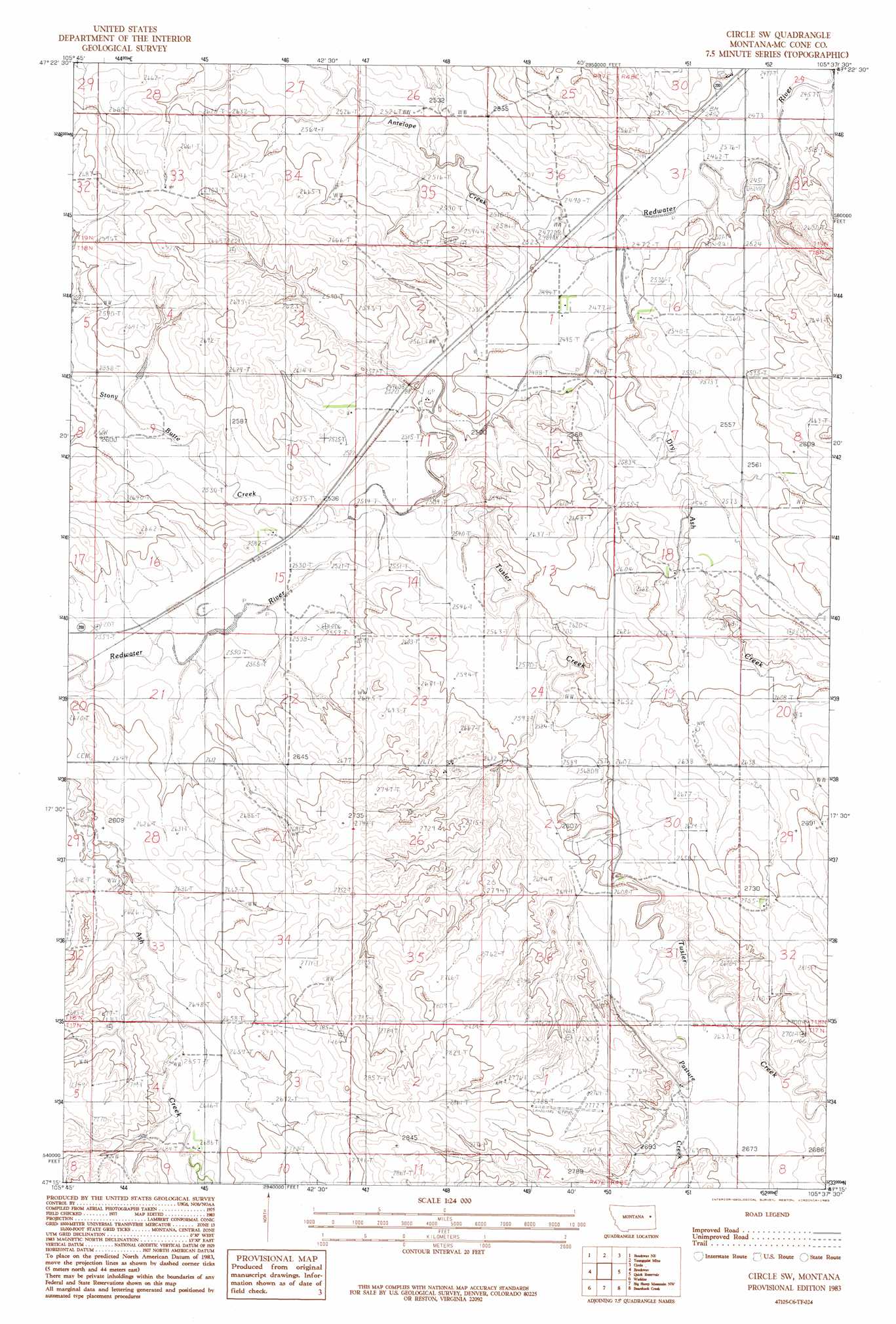
USGS Topo Quad 47105c6 - 1:24,000 scale
| Topo Map Name: | Circle Sw |
| USGS Topo Quad ID: | 47105c6 |
| Print Size: | ca. 21 1/4" wide x 27" high |
| Southeast Coordinates: | 47.25° N latitude / 105.625° W longitude |
| Map Center Coordinates: | 47.3125° N latitude / 105.6875° W longitude |
| U.S. State: | MT |
| Filename: | o47105c6.jpg |
| Download Map JPG Image: | Circle Sw topo map 1:24,000 scale |
| Map Type: | Topographic |
| Topo Series: | 7.5´ |
| Map Scale: | 1:24,000 |
| Source of Map Images: | United States Geological Survey (USGS) |
| Alternate Map Versions: |
Circle SW MT 1983, updated 1983 Download PDF Buy paper map Circle SW MT 2011 Download PDF Buy paper map Circle SW MT 2014 Download PDF Buy paper map |
1:24,000 Topo Quads surrounding Circle Sw
Weldon |
North Fork Horse Creek |
Haynie Reservoir |
Hudiburgh Res. Se |
Buffalo Creek |
Johnson Coulee East |
Brockway Ne |
Youngquist Mine |
Circle |
Woodworth Hill |
Beauty Creek |
Brockway |
Circle Sw |
Quick Reservoir |
Mount Antelope |
Berry School |
Watkins |
Big Sheep Mountain Nw |
Bearshack Creek |
Diamond G Butte Nw |
Heitz School |
Watkins Se |
Big Sheep Mountain |
Becker Dam |
North Coulee |
> Back to 47105a1 at 1:100,000 scale
> Back to 47104a1 at 1:250,000 scale
> Back to U.S. Topo Maps home
Circle Sw topo map: Gazetteer
Circle Sw: Dams
Harvard Dam elevation 770m 2526′R Mothershead Dam elevation 785m 2575′
Circle Sw: Post Offices
Stony Butte Post Office (historical) elevation 781m 2562′Circle Sw: Streams
Antelope Creek elevation 754m 2473′Dry Ash Creek elevation 758m 2486′
McCune Creek elevation 749m 2457′
Pasture Creek elevation 799m 2621′
Stony Butte Creek elevation 770m 2526′
Tusler Creek elevation 767m 2516′
Circle Sw: Wells
17N47E01BCDA01 Well elevation 844m 2769′17N47E04ACBA01 Well elevation 800m 2624′
18N47E02DBCD01 Well elevation 788m 2585′
18N47E10ADAA01 Well elevation 776m 2545′
18N48E17BAA_01 Well elevation 797m 2614′
19N47E25DBCB01 Well elevation 789m 2588′
19N47E26CDDC01 Well elevation 774m 2539′
19N47E26DCDD01 Well elevation 776m 2545′
19N47E33DBBB01 Well elevation 811m 2660′
19N47E36DCBB01 Well elevation 759m 2490′
Circle Sw digital topo map on disk
Buy this Circle Sw topo map showing relief, roads, GPS coordinates and other geographical features, as a high-resolution digital map file on DVD:
Eastern Montana & Western North Dakota
Buy digital topo maps: Eastern Montana & Western North Dakota