Hudiburgh Res. Se Topo Map Montana
To zoom in, hover over the map of Hudiburgh Res. Se
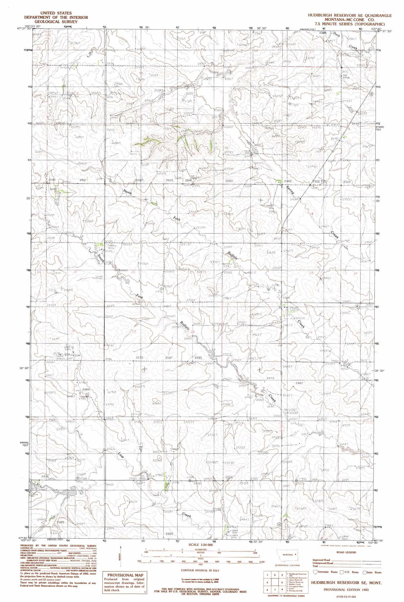
USGS Topo Quad 47105e5 - 1:24,000 scale
| Topo Map Name: | Hudiburgh Res. Se |
| USGS Topo Quad ID: | 47105e5 |
| Print Size: | ca. 21 1/4" wide x 27" high |
| Southeast Coordinates: | 47.5° N latitude / 105.5° W longitude |
| Map Center Coordinates: | 47.5625° N latitude / 105.5625° W longitude |
| U.S. State: | MT |
| Filename: | o47105e5.jpg |
| Download Map JPG Image: | Hudiburgh Res. Se topo map 1:24,000 scale |
| Map Type: | Topographic |
| Topo Series: | 7.5´ |
| Map Scale: | 1:24,000 |
| Source of Map Images: | United States Geological Survey (USGS) |
| Alternate Map Versions: |
Hudiburgh Reservoir SE MT 1983, updated 1983 Download PDF Buy paper map Hudiburgh Reservoir SE MT 2011 Download PDF Buy paper map Hudiburgh Reservoir SE MT 2014 Download PDF Buy paper map |
1:24,000 Topo Quads surrounding Hudiburgh Res. Se
Sadie Coulee |
Dailey Spring |
Lone Pine School |
Vida |
Kraut Coulee |
Pedigo Coulee |
Hudiburgh Res. |
Hudiburgh Res. |
Beery Reservoir |
Buffalo Creek Ne |
North Fork Horse Creek |
Haynie Reservoir |
Hudiburgh Res. Se |
Buffalo Creek |
Buffalo Creek Se |
Brockway Ne |
Youngquist Mine |
Circle |
Woodworth Hill |
Olson Coulee North |
Brockway |
Circle Sw |
Quick Reservoir |
Mount Antelope |
Olson Coulee South |
> Back to 47105e1 at 1:100,000 scale
> Back to 47104a1 at 1:250,000 scale
> Back to U.S. Topo Maps home
Hudiburgh Res. Se topo map: Gazetteer
Hudiburgh Res. Se: Dams
Pawlowski Number 1 Dam elevation 733m 2404′Hudiburgh Res. Se: Populated Places
Lost Creek (historical) elevation 739m 2424′Hudiburgh Res. Se: Wells
20N48E01AADB01 Well elevation 762m 2500′20N48E02CCCC01 Well elevation 755m 2477′
20N48E02CCCC02 Well elevation 755m 2477′
20N48E04ACDC01 Well elevation 735m 2411′
20N48E04DCDD01 Well elevation 745m 2444′
20N48E08AAAC01 Well elevation 749m 2457′
20N48E08AAAC02 Well elevation 749m 2457′
20N48E08AABA01 Well elevation 753m 2470′
20N48E10ABAB01 Well elevation 738m 2421′
20N48E10ABAB02 Well elevation 738m 2421′
20N48E11BBCC01 Well elevation 746m 2447′
20N48E11BBCC02 Well elevation 746m 2447′
20N49E06BDBD01 Well elevation 749m 2457′
20N49E07CBCA01 Well elevation 771m 2529′
21N48E02ADDD01 Well elevation 759m 2490′
21N48E09BACA01 Well elevation 769m 2522′
21N48E10BDDD01 Well elevation 761m 2496′
21N48E10DDDC01 Well elevation 755m 2477′
21N48E10DDDC02 Well elevation 755m 2477′
21N48E12BBCB01 Well elevation 760m 2493′
21N48E12BBDC01 Well elevation 750m 2460′
21N48E15ADBD01 Well elevation 768m 2519′
21N48E22BCAC01 Well elevation 756m 2480′
21N48E22CCCD01 Well elevation 785m 2575′
21N48E22DDAB01 Well elevation 759m 2490′
21N48E25BABB01 Well elevation 749m 2457′
21N48E26BBBC01 Well elevation 758m 2486′
21N48E26BBCC01 Well elevation 753m 2470′
21N48E26BBCD01 Well elevation 753m 2470′
21N48E27BDCC01 Well elevation 783m 2568′
21N48E30CDAA01 Well elevation 779m 2555′
21N48E31DACB01 Well elevation 767m 2516′
22N48E34DDDC01 Well elevation 745m 2444′
Hudiburgh Res. Se digital topo map on disk
Buy this Hudiburgh Res. Se topo map showing relief, roads, GPS coordinates and other geographical features, as a high-resolution digital map file on DVD:
Eastern Montana & Western North Dakota
Buy digital topo maps: Eastern Montana & Western North Dakota