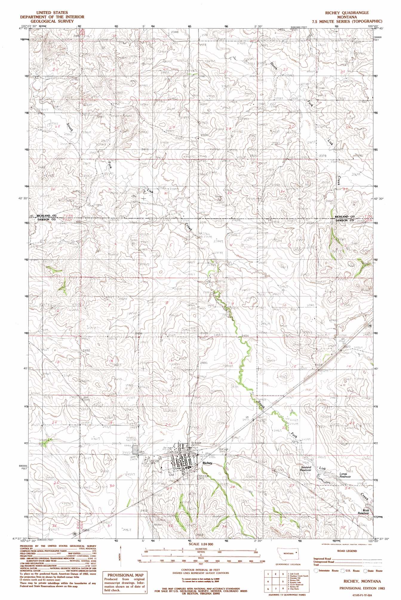
Richey Topo Map Montana
To zoom in, hover over the map of Richey
USGS Topo Quad 47105f1 - 1:24,000 scale
| Topo Map Name: | Richey |
| USGS Topo Quad ID: | 47105f1 |
| Print Size: | ca. 21 1/4" wide x 27" high |
| Southeast Coordinates: | 47.625° N latitude / 105° W longitude |
| Map Center Coordinates: | 47.6875° N latitude / 105.0625° W longitude |
| U.S. State: | MT |
| Filename: | o47105f1.jpg |
| Download Map JPG Image: | Richey topo map 1:24,000 scale |
| Map Type: | Topographic |
| Topo Series: | 7.5´ |
| Map Scale: | 1:24,000 |
| Source of Map Images: | United States Geological Survey (USGS) |
| Alternate Map Versions: |
Richey MT 1983, updated 1983 Download PDF Buy paper map Richey MT 2011 Download PDF Buy paper map Richey MT 2014 Download PDF Buy paper map |
1:24,000 Topo Quads surrounding Richey
Dowse Coulee |
Sullivan Coulee |
Duplisse Creek North |
Elmdale Nw |
Elmdale |
Kraut Coulee |
Lisk Creek |
Duplisse Creek South |
Elmdale Sw |
Carda Coulee |
Buffalo Creek Ne |
Richey Nw |
Richey |
Kuester Lake |
Enid |
Buffalo Creek Se |
Circle Reservoir |
Richey Se |
Clay Butte |
Enid Se |
Olson Coulee North |
Johnson Reservoir Nw |
Johnson Reservoir Ne |
Bloomfield |
Red Top |
> Back to 47105e1 at 1:100,000 scale
> Back to 47104a1 at 1:250,000 scale
> Back to U.S. Topo Maps home
Richey topo map: Gazetteer
Richey: Airports
Richey Airport elevation 768m 2519′Richey: Dams
Ding-A-Ling Dam elevation 776m 2545′Roy Richey Dam elevation 751m 2463′
Senner Number 1 Dam elevation 749m 2457′
Wold Dam elevation 754m 2473′
Richey: Parks
Richey Community Park elevation 765m 2509′Richey Historical Marker elevation 763m 2503′
Richey: Populated Places
Richey elevation 763m 2503′Richey Trailer Court elevation 767m 2516′
Richey: Post Offices
Richey Post Office elevation 759m 2490′Richey: Reservoirs
Keeland Reservoir elevation 752m 2467′Longs Reservoir elevation 753m 2470′
Roy Richey Reservoir elevation 751m 2463′
Wold Reservoir elevation 755m 2477′
Richey: Wells
22N51E01ADDA01 Well elevation 734m 2408′22N52E04CABD01 Well elevation 735m 2411′
22N52E06BACA01 Well elevation 742m 2434′
22N52E14BACD01 Well elevation 734m 2408′
22N52E17BACC01 Well elevation 780m 2559′
22N52E20DC__01 Well elevation 758m 2486′
22N52E28B___01 Well elevation 767m 2516′
22N52E30ABBD01 Well elevation 750m 2460′
22N52E30ABBD02 Well elevation 750m 2460′
22N52E30ADDC01 Well elevation 754m 2473′
22N52E30DCCD01 Well elevation 745m 2444′
22N52E33ABBA01 Well elevation 778m 2552′
23N52E14DCCD01 Well elevation 742m 2434′
23N52E15DDCA01 Well elevation 729m 2391′
23N52E20DABD01 Well elevation 735m 2411′
23N52E22BDDC01 Well elevation 719m 2358′
23N52E27BBAD01 Well elevation 734m 2408′
23N52E28AAAC01 Well elevation 731m 2398′
23N52E29CDDC01 Well elevation 741m 2431′
23N52E32DCDA01 Well elevation 725m 2378′
23N52E32DCDB01 Well elevation 724m 2375′
23N52E34AADD01 Well elevation 739m 2424′
Richey digital topo map on disk
Buy this Richey topo map showing relief, roads, GPS coordinates and other geographical features, as a high-resolution digital map file on DVD:
Eastern Montana & Western North Dakota
Buy digital topo maps: Eastern Montana & Western North Dakota