Buffalo Creek Ne Topo Map Montana
To zoom in, hover over the map of Buffalo Creek Ne
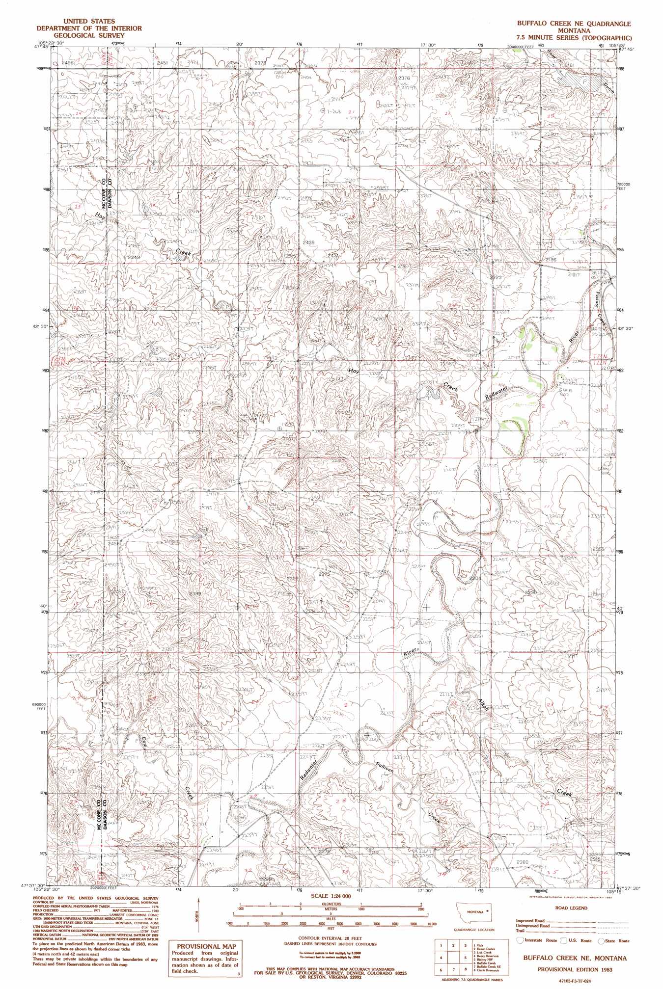
USGS Topo Quad 47105f3 - 1:24,000 scale
| Topo Map Name: | Buffalo Creek Ne |
| USGS Topo Quad ID: | 47105f3 |
| Print Size: | ca. 21 1/4" wide x 27" high |
| Southeast Coordinates: | 47.625° N latitude / 105.25° W longitude |
| Map Center Coordinates: | 47.6875° N latitude / 105.3125° W longitude |
| U.S. State: | MT |
| Filename: | o47105f3.jpg |
| Download Map JPG Image: | Buffalo Creek Ne topo map 1:24,000 scale |
| Map Type: | Topographic |
| Topo Series: | 7.5´ |
| Map Scale: | 1:24,000 |
| Source of Map Images: | United States Geological Survey (USGS) |
| Alternate Map Versions: |
Buffalo Creek NE MT 1983, updated 1983 Download PDF Buy paper map Buffalo Creek NE MT 2011 Download PDF Buy paper map Buffalo Creek NE MT 2014 Download PDF Buy paper map |
1:24,000 Topo Quads surrounding Buffalo Creek Ne
Rock Creek |
Gady Coulee |
Dowse Coulee |
Sullivan Coulee |
Duplisse Creek North |
Lone Pine School |
Vida |
Kraut Coulee |
Lisk Creek |
Duplisse Creek South |
Hudiburgh Res. |
Beery Reservoir |
Buffalo Creek Ne |
Richey Nw |
Richey |
Hudiburgh Res. Se |
Buffalo Creek |
Buffalo Creek Se |
Circle Reservoir |
Richey Se |
Circle |
Woodworth Hill |
Olson Coulee North |
Johnson Reservoir Nw |
Johnson Reservoir Ne |
> Back to 47105e1 at 1:100,000 scale
> Back to 47104a1 at 1:250,000 scale
> Back to U.S. Topo Maps home
Buffalo Creek Ne topo map: Gazetteer
Buffalo Creek Ne: Dams
2350 Redwater Dam elevation 685m 2247′Berrys Land Number 2 Dam elevation 736m 2414′
Berrys Land Number 3 Dam elevation 715m 2345′
Smile Number 1 Dam elevation 740m 2427′
Buffalo Creek Ne: Populated Places
Paxton (historical) elevation 674m 2211′Buffalo Creek Ne: Post Offices
Axtell Post Office (historical) elevation 676m 2217′Paxton Post Office (historical) elevation 674m 2211′
Riverside Post Office (historical) elevation 663m 2175′
Buffalo Creek Ne: Streams
Alkali Creek elevation 670m 2198′Cow Creek elevation 682m 2237′
Hay Creek elevation 669m 2194′
Sullivan Creek elevation 672m 2204′
Buffalo Creek Ne: Valleys
Gold Gulch elevation 661m 2168′Buffalo Creek Ne: Wells
22N50E06BCAC01 Well elevation 736m 2414′22N50E08ADBB01 Well elevation 739m 2424′
22N50E20DADC01 Well elevation 688m 2257′
22N50E22ACAD01 Well elevation 685m 2247′
22N50E29CCCA01 Well elevation 681m 2234′
22N50E29CCCB01 Well elevation 681m 2234′
22N50E29CCCC01 Well elevation 680m 2230′
22N50E29CCDB01 Well elevation 681m 2234′
22N50E35AAAD01 Well elevation 705m 2312′
23N50E19BBB_01 Well elevation 768m 2519′
23N50E19BDC_01 Well elevation 755m 2477′
23N50E19DCC_01 Well elevation 739m 2424′
23N50E22CBCD01 Well elevation 730m 2395′
23N50E26ACAD01 Well elevation 666m 2185′
23N50E27ADAD01 Well elevation 679m 2227′
23N50E30BBAB01 Well elevation 730m 2395′
23N50E34DBBC01 Well elevation 711m 2332′
23N50E35CCAC01 Well elevation 668m 2191′
Buffalo Creek Ne digital topo map on disk
Buy this Buffalo Creek Ne topo map showing relief, roads, GPS coordinates and other geographical features, as a high-resolution digital map file on DVD:
Eastern Montana & Western North Dakota
Buy digital topo maps: Eastern Montana & Western North Dakota