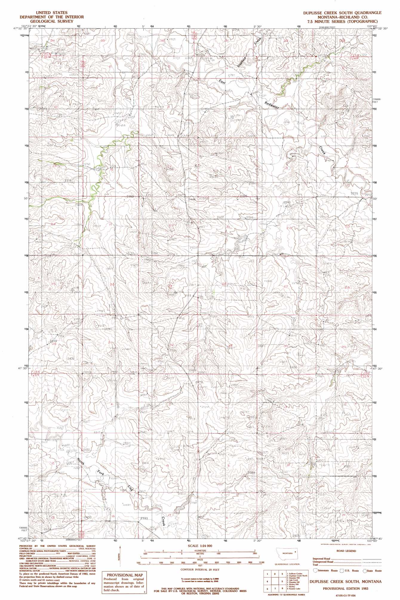
Duplisse Creek South Topo Map Montana
To zoom in, hover over the map of Duplisse Creek South
USGS Topo Quad 47105g1 - 1:24,000 scale
| Topo Map Name: | Duplisse Creek South |
| USGS Topo Quad ID: | 47105g1 |
| Print Size: | ca. 21 1/4" wide x 27" high |
| Southeast Coordinates: | 47.75° N latitude / 105° W longitude |
| Map Center Coordinates: | 47.8125° N latitude / 105.0625° W longitude |
| U.S. State: | MT |
| Filename: | o47105g1.jpg |
| Download Map JPG Image: | Duplisse Creek South topo map 1:24,000 scale |
| Map Type: | Topographic |
| Topo Series: | 7.5´ |
| Map Scale: | 1:24,000 |
| Source of Map Images: | United States Geological Survey (USGS) |
| Alternate Map Versions: |
Duplisse Creek South MT 1983, updated 1983 Download PDF Buy paper map Duplisse Creek South MT 2011 Download PDF Buy paper map Duplisse Creek South MT 2014 Download PDF Buy paper map |
1:24,000 Topo Quads surrounding Duplisse Creek South
Nickwall |
Poplar |
Sprole |
Mortarstone Bluff |
Frog Coulee |
Dowse Coulee |
Sullivan Coulee |
Duplisse Creek North |
Elmdale Nw |
Elmdale |
Kraut Coulee |
Lisk Creek |
Duplisse Creek South |
Elmdale Sw |
Carda Coulee |
Buffalo Creek Ne |
Richey Nw |
Richey |
Kuester Lake |
Enid |
Buffalo Creek Se |
Circle Reservoir |
Richey Se |
Clay Butte |
Enid Se |
> Back to 47105e1 at 1:100,000 scale
> Back to 47104a1 at 1:250,000 scale
> Back to U.S. Topo Maps home
Duplisse Creek South topo map: Gazetteer
Duplisse Creek South: Dams
Bahls Dam elevation 706m 2316′Crocket Dam elevation 694m 2276′
Fatzinger Number 2 Dam elevation 668m 2191′
Win Number 2 Dam elevation 738m 2421′
Duplisse Creek South: Streams
Duplisse Creek elevation 663m 2175′Duplisse Creek South: Wells
23N51E12ADCC01 Well elevation 693m 2273′23N51E13ABAB01 Well elevation 716m 2349′
23N52E07CDCA01 Well elevation 702m 2303′
23N52E07CDDB01 Well elevation 702m 2303′
23N52E09BCAB01 Well elevation 734m 2408′
23N52E16CBCD01 Well elevation 711m 2332′
23N52E18BDAC01 Well elevation 707m 2319′
23N52E18BDBA01 Well elevation 715m 2345′
24N51E24DDAB01 Well elevation 704m 2309′
24N52E18CABB01 Well elevation 681m 2234′
24N52E22CBBD01 Well elevation 687m 2253′
24N52E22CBCA01 Well elevation 686m 2250′
24N52E22DCDD01 Well elevation 690m 2263′
24N52E28BBAD01 Well elevation 702m 2303′
24N52E28CAAB01 Well elevation 713m 2339′
24N52E29ABBA01 Well elevation 714m 2342′
24N52E33BBCA01 Well elevation 732m 2401′
Duplisse Creek South digital topo map on disk
Buy this Duplisse Creek South topo map showing relief, roads, GPS coordinates and other geographical features, as a high-resolution digital map file on DVD:
Eastern Montana & Western North Dakota
Buy digital topo maps: Eastern Montana & Western North Dakota