Dailey Spring Topo Map Montana
To zoom in, hover over the map of Dailey Spring
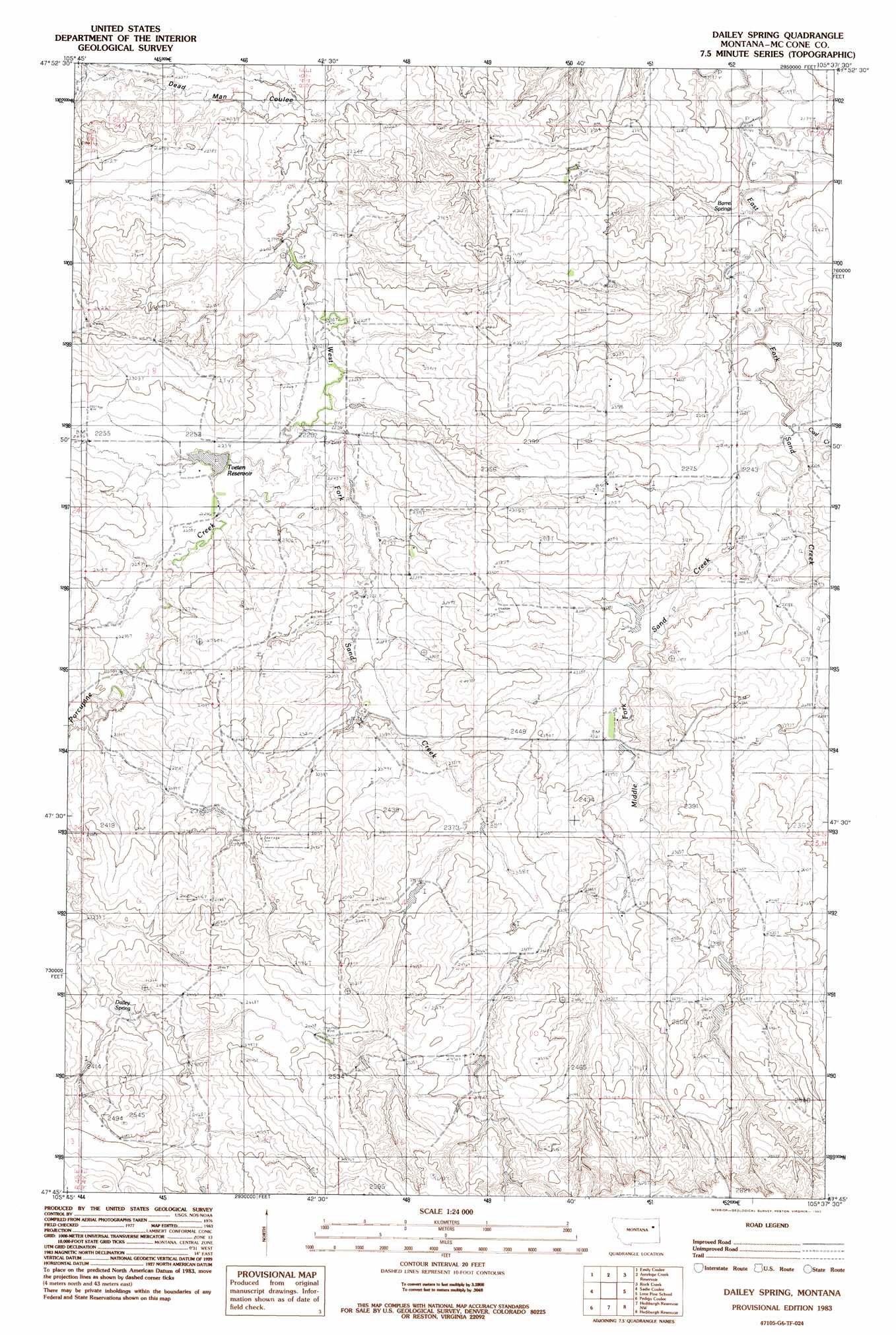
USGS Topo Quad 47105g6 - 1:24,000 scale
| Topo Map Name: | Dailey Spring |
| USGS Topo Quad ID: | 47105g6 |
| Print Size: | ca. 21 1/4" wide x 27" high |
| Southeast Coordinates: | 47.75° N latitude / 105.625° W longitude |
| Map Center Coordinates: | 47.8125° N latitude / 105.6875° W longitude |
| U.S. State: | MT |
| Filename: | o47105g6.jpg |
| Download Map JPG Image: | Dailey Spring topo map 1:24,000 scale |
| Map Type: | Topographic |
| Topo Series: | 7.5´ |
| Map Scale: | 1:24,000 |
| Source of Map Images: | United States Geological Survey (USGS) |
| Alternate Map Versions: |
Dailey Spring MT 1983, updated 1983 Download PDF Buy paper map Dailey Spring MT 2011 Download PDF Buy paper map Dailey Spring MT 2014 Download PDF Buy paper map |
1:24,000 Topo Quads surrounding Dailey Spring
Oswego |
Flynn Creek South |
Wolf Point |
Macon |
Chelsea Sw |
Turtle Creek |
Emily Coulee |
Antelope Creek Res. |
Rock Creek |
Gady Coulee |
Shade Creek |
Sadie Coulee |
Dailey Spring |
Lone Pine School |
Vida |
Figure Eight Creek |
Pedigo Coulee |
Hudiburgh Res. |
Hudiburgh Res. |
Beery Reservoir |
Weldon |
North Fork Horse Creek |
Haynie Reservoir |
Hudiburgh Res. Se |
Buffalo Creek |
> Back to 47105e1 at 1:100,000 scale
> Back to 47104a1 at 1:250,000 scale
> Back to U.S. Topo Maps home
Dailey Spring topo map: Gazetteer
Dailey Spring: Dams
F Whitmus Number 2 Dam elevation 726m 2381′Fiske Dam elevation 734m 2408′
Whitmus Stock Reservoir Dam elevation 733m 2404′
Dailey Spring: Populated Places
Sand Creek (historical) elevation 722m 2368′Dailey Spring: Post Offices
Kellogg Post Office (historical) elevation 770m 2526′Sand Creek Post Office (historical) elevation 722m 2368′
Dailey Spring: Reservoirs
Tveten Reservoir elevation 682m 2237′Dailey Spring: Springs
Barrel Springs elevation 659m 2162′Dailey Spring elevation 719m 2358′
Dailey Spring: Streams
Coal Creek elevation 671m 2201′Middle Fork Sand Creek elevation 673m 2208′
Porcupine Creek elevation 677m 2221′
Dailey Spring: Valleys
Dead Man Coulee elevation 666m 2185′Dailey Spring: Wells
24N47E18CB__01 Well elevation 692m 2270′24N47E35BBBA01 Well elevation 707m 2319′
24N47E35BBBC01 Well elevation 707m 2319′
Dailey Spring digital topo map on disk
Buy this Dailey Spring topo map showing relief, roads, GPS coordinates and other geographical features, as a high-resolution digital map file on DVD:
Eastern Montana & Western North Dakota
Buy digital topo maps: Eastern Montana & Western North Dakota