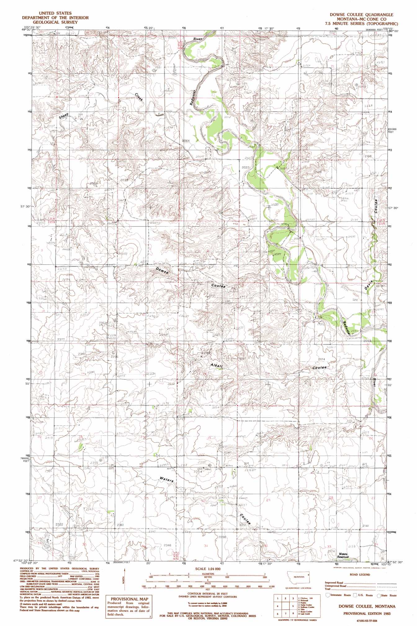
Dowse Coulee Topo Map Montana
To zoom in, hover over the map of Dowse Coulee
USGS Topo Quad 47105h3 - 1:24,000 scale
| Topo Map Name: | Dowse Coulee |
| USGS Topo Quad ID: | 47105h3 |
| Print Size: | ca. 21 1/4" wide x 27" high |
| Southeast Coordinates: | 47.875° N latitude / 105.25° W longitude |
| Map Center Coordinates: | 47.9375° N latitude / 105.3125° W longitude |
| U.S. State: | MT |
| Filename: | o47105h3.jpg |
| Download Map JPG Image: | Dowse Coulee topo map 1:24,000 scale |
| Map Type: | Topographic |
| Topo Series: | 7.5´ |
| Map Scale: | 1:24,000 |
| Source of Map Images: | United States Geological Survey (USGS) |
| Alternate Map Versions: |
Dowse Coulee MT 1983, updated 1983 Download PDF Buy paper map Dowse Coulee MT 2011 Download PDF Buy paper map Dowse Coulee MT 2014 Download PDF Buy paper map |
1:24,000 Topo Quads surrounding Dowse Coulee
Wolf Point Ne |
Chelsea Nw |
Chelsea |
Badger Creek |
Poplar Ne |
Macon |
Chelsea Sw |
Nickwall |
Poplar |
Sprole |
Rock Creek |
Gady Coulee |
Dowse Coulee |
Sullivan Coulee |
Duplisse Creek North |
Lone Pine School |
Vida |
Kraut Coulee |
Lisk Creek |
Duplisse Creek South |
Hudiburgh Res. |
Beery Reservoir |
Buffalo Creek Ne |
Richey Nw |
Richey |
> Back to 47105e1 at 1:100,000 scale
> Back to 47104a1 at 1:250,000 scale
> Back to U.S. Topo Maps home
Dowse Coulee topo map: Gazetteer
Dowse Coulee: Dams
Paul Huber Dam elevation 700m 2296′Robert Johnson Dam elevation 702m 2303′
Waters Dam Number 1 elevation 650m 2132′
Dowse Coulee: Reservoirs
Waters Reservoir elevation 648m 2125′Dowse Coulee: Streams
Sheep Creek elevation 621m 2037′Dowse Coulee: Valleys
Alkali Coulee elevation 614m 2014′Davis Coulee elevation 639m 2096′
Dowse Coulee elevation 615m 2017′
Dowse Coulee: Wells
25N49E01DBCD01 Well elevation 687m 2253′25N49E34AA__01 Well elevation 698m 2290′
25N50E09CBAD01 Well elevation 631m 2070′
25N50E21CCCC01 Well elevation 683m 2240′
26N50E33BDAD01 Well elevation 655m 2148′
Dowse Coulee digital topo map on disk
Buy this Dowse Coulee topo map showing relief, roads, GPS coordinates and other geographical features, as a high-resolution digital map file on DVD:
Eastern Montana & Western North Dakota
Buy digital topo maps: Eastern Montana & Western North Dakota