Hedstrom Lake Nw Topo Map Montana
To zoom in, hover over the map of Hedstrom Lake Nw
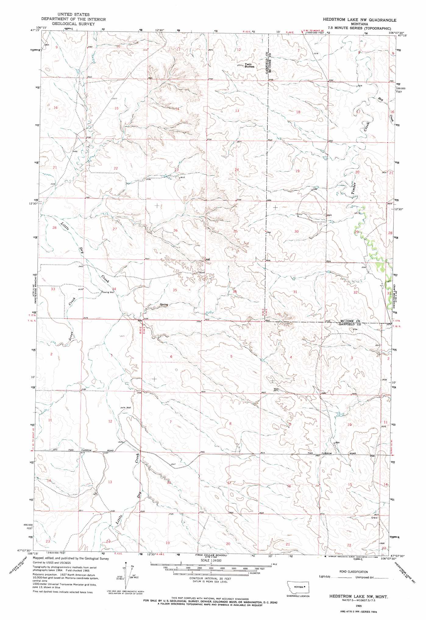
USGS Topo Quad 47106b2 - 1:24,000 scale
| Topo Map Name: | Hedstrom Lake Nw |
| USGS Topo Quad ID: | 47106b2 |
| Print Size: | ca. 21 1/4" wide x 27" high |
| Southeast Coordinates: | 47.125° N latitude / 106.125° W longitude |
| Map Center Coordinates: | 47.1875° N latitude / 106.1875° W longitude |
| U.S. State: | MT |
| Filename: | o47106b2.jpg |
| Download Map JPG Image: | Hedstrom Lake Nw topo map 1:24,000 scale |
| Map Type: | Topographic |
| Topo Series: | 7.5´ |
| Map Scale: | 1:24,000 |
| Source of Map Images: | United States Geological Survey (USGS) |
| Alternate Map Versions: |
Hedstrom Lake NW MT 1965, updated 1968 Download PDF Buy paper map Hedstrom Lake NW MT 2011 Download PDF Buy paper map Hedstrom Lake NW MT 2014 Download PDF Buy paper map |
1:24,000 Topo Quads surrounding Hedstrom Lake Nw
Hagen Gap |
Frank Coulee |
Fortyfour Coulee |
Johnson Coulee West |
Johnson Coulee East |
Maxwell Coulee |
Coal Creek |
Flowing Well |
Cemetery Coulee |
Beauty Creek |
Hafla School |
Whiteside Ranch |
Hedstrom Lake Nw |
Hedstrom Lake |
Berry School |
Calamity Coulee |
Sleepy Hollow |
Tree Coulee School |
Hedstrom Lake Se |
Heitz School |
Hillside |
Coleman Coulee |
Little Chalk Butte |
Crow Rock |
Combs Ranch |
> Back to 47106a1 at 1:100,000 scale
> Back to 47106a1 at 1:250,000 scale
> Back to U.S. Topo Maps home
Hedstrom Lake Nw topo map: Gazetteer
Hedstrom Lake Nw: Populated Places
Purewater (historical) elevation 759m 2490′Hedstrom Lake Nw: Post Offices
Purewater Post Office (historical) elevation 759m 2490′Hedstrom Lake Nw: Streams
Hay Creek elevation 761m 2496′Jones Creek elevation 747m 2450′
Hedstrom Lake Nw: Summits
Twin Buttes elevation 836m 2742′Hedstrom Lake Nw: Wells
16N43E12ACAA01 Well elevation 753m 2470′16N44E04CDCC01 Well elevation 813m 2667′
16N44E08DCBA01 Well elevation 793m 2601′
17N44E17BAAD01 Well elevation 768m 2519′
17N44E19ABBB01 Well elevation 792m 2598′
17N44E29ABBB01 Well elevation 774m 2539′
17N44E30ABBC01 Well elevation 799m 2621′
17N44E32ADAA01 Well elevation 777m 2549′
17N44E32ADAC01 Well elevation 775m 2542′
17N44E32ADAC02 Well elevation 775m 2542′
17N44E32ADAC03 Well elevation 775m 2542′
17N44E32ADAD01 Well elevation 777m 2549′
Hedstrom Lake Nw digital topo map on disk
Buy this Hedstrom Lake Nw topo map showing relief, roads, GPS coordinates and other geographical features, as a high-resolution digital map file on DVD:
Eastern Montana & Western North Dakota
Buy digital topo maps: Eastern Montana & Western North Dakota