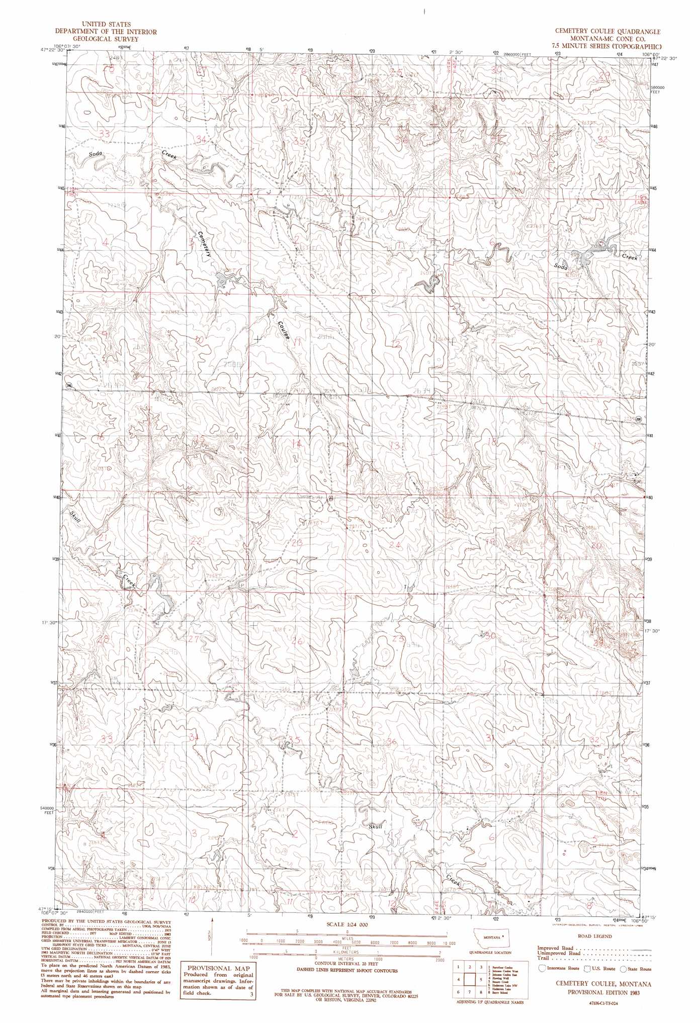
Cemetery Coulee Topo Map Montana
To zoom in, hover over the map of Cemetery Coulee
USGS Topo Quad 47106c1 - 1:24,000 scale
| Topo Map Name: | Cemetery Coulee |
| USGS Topo Quad ID: | 47106c1 |
| Print Size: | ca. 21 1/4" wide x 27" high |
| Southeast Coordinates: | 47.25° N latitude / 106° W longitude |
| Map Center Coordinates: | 47.3125° N latitude / 106.0625° W longitude |
| U.S. State: | MT |
| Filename: | o47106c1.jpg |
| Download Map JPG Image: | Cemetery Coulee topo map 1:24,000 scale |
| Map Type: | Topographic |
| Topo Series: | 7.5´ |
| Map Scale: | 1:24,000 |
| Source of Map Images: | United States Geological Survey (USGS) |
| Alternate Map Versions: |
Cemetery Coulee MT 1983, updated 1983 Download PDF Buy paper map Cemetery Coulee MT 2011 Download PDF Buy paper map Cemetery Coulee MT 2014 Download PDF Buy paper map |
1:24,000 Topo Quads surrounding Cemetery Coulee
Short Creek |
Nelson Creek Bay |
Rodgers Hall |
Weldon |
North Fork Horse Creek |
Frank Coulee |
Fortyfour Coulee |
Johnson Coulee West |
Johnson Coulee East |
Brockway Ne |
Coal Creek |
Flowing Well |
Cemetery Coulee |
Beauty Creek |
Brockway |
Whiteside Ranch |
Hedstrom Lake Nw |
Hedstrom Lake |
Berry School |
Watkins |
Sleepy Hollow |
Tree Coulee School |
Hedstrom Lake Se |
Heitz School |
Watkins Se |
> Back to 47106a1 at 1:100,000 scale
> Back to 47106a1 at 1:250,000 scale
> Back to U.S. Topo Maps home
Cemetery Coulee topo map: Gazetteer
Cemetery Coulee: Dams
Hannaland Number 3 Dam elevation 753m 2470′Hannaland Number 4 Dam elevation 750m 2460′
Hannaland Number 5 Dam elevation 782m 2565′
Hannaland Number 6 Dam elevation 766m 2513′
Hannaland Reservoir Dam elevation 771m 2529′
Walkerville Dam elevation 762m 2500′
Cemetery Coulee: Populated Places
White (historical) elevation 809m 2654′Cemetery Coulee: Post Offices
White Post Office (historical) elevation 809m 2654′Cemetery Coulee: Valleys
Cemetery Coulee elevation 749m 2457′Cemetery Coulee: Wells
17N44E01ACAA01 Well elevation 791m 2595′17N44E02BAAB01 Well elevation 786m 2578′
17N44E02BABA01 Well elevation 779m 2555′
17N44E03ADCD01 Well elevation 787m 2582′
17N44E10ABAA01 Well elevation 796m 2611′
17N44E12ABBC01 Well elevation 791m 2595′
17N44E12ABBC02 Well elevation 791m 2595′
17N45E05CAAA01 Well elevation 827m 2713′
17N45E06AAAA01 Well elevation 799m 2621′
17N45E06ABBD01 Well elevation 798m 2618′
18N44E13AAAC01 Well elevation 786m 2578′
18N44E14ABAC01 Well elevation 779m 2555′
18N44E14BABD01 Well elevation 779m 2555′
18N45E30DDCB01 Well elevation 831m 2726′
19N44E21DCDD01 Well elevation 768m 2519′
19N44E33ACCD01 Well elevation 750m 2460′
Cemetery Coulee digital topo map on disk
Buy this Cemetery Coulee topo map showing relief, roads, GPS coordinates and other geographical features, as a high-resolution digital map file on DVD:
Eastern Montana & Western North Dakota
Buy digital topo maps: Eastern Montana & Western North Dakota