Fortyfour Coulee Topo Map Montana
To zoom in, hover over the map of Fortyfour Coulee
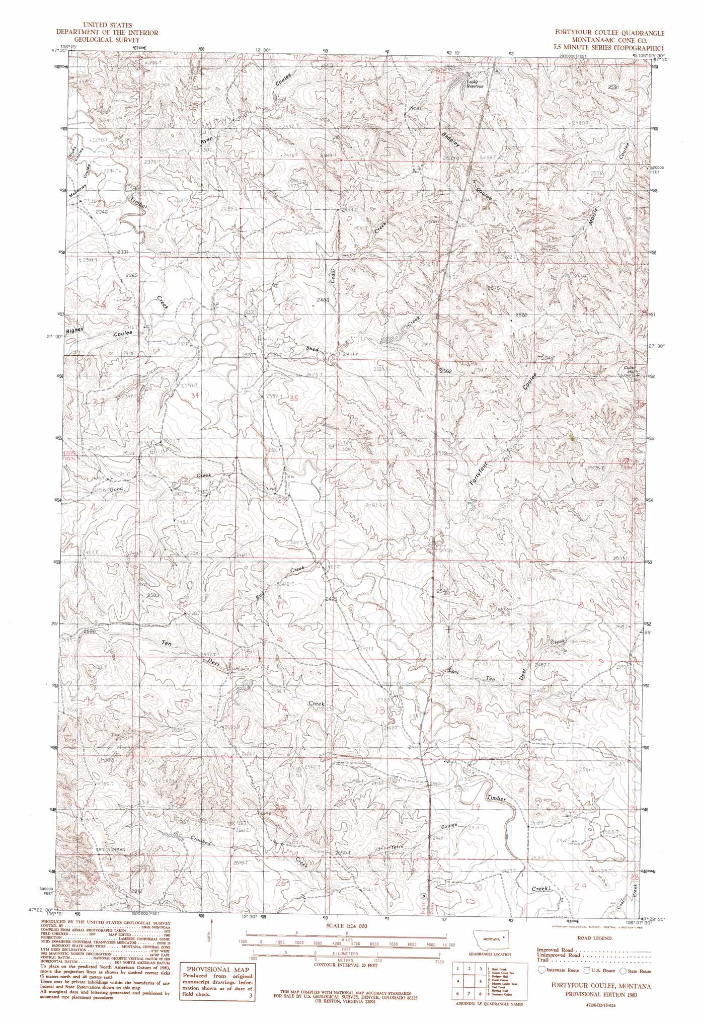
USGS Topo Quad 47106d2 - 1:24,000 scale
| Topo Map Name: | Fortyfour Coulee |
| USGS Topo Quad ID: | 47106d2 |
| Print Size: | ca. 21 1/4" wide x 27" high |
| Southeast Coordinates: | 47.375° N latitude / 106.125° W longitude |
| Map Center Coordinates: | 47.4375° N latitude / 106.1875° W longitude |
| U.S. State: | MT |
| Filename: | o47106d2.jpg |
| Download Map JPG Image: | Fortyfour Coulee topo map 1:24,000 scale |
| Map Type: | Topographic |
| Topo Series: | 7.5´ |
| Map Scale: | 1:24,000 |
| Source of Map Images: | United States Geological Survey (USGS) |
| Alternate Map Versions: |
Fortyfour Coulee MT 1983, updated 1983 Download PDF Buy paper map Fortyfour Coulee MT 2011 Download PDF Buy paper map Fortyfour Coulee MT 2014 Download PDF Buy paper map |
1:24,000 Topo Quads surrounding Fortyfour Coulee
Ash Creek West |
Ash Creek East |
Bug Creek |
Crow Springs |
Figure Eight Creek |
Flat Creek School |
Short Creek |
Nelson Creek Bay |
Rodgers Hall |
Weldon |
Hagen Gap |
Frank Coulee |
Fortyfour Coulee |
Johnson Coulee West |
Johnson Coulee East |
Maxwell Coulee |
Coal Creek |
Flowing Well |
Cemetery Coulee |
Beauty Creek |
Hafla School |
Whiteside Ranch |
Hedstrom Lake Nw |
Hedstrom Lake |
Berry School |
> Back to 47106a1 at 1:100,000 scale
> Back to 47106a1 at 1:250,000 scale
> Back to U.S. Topo Maps home
Fortyfour Coulee topo map: Gazetteer
Fortyfour Coulee: Dams
D Hinnaland Number 1 Dam elevation 743m 2437′Fortyfour Coulee: Reservoirs
Leaky Reservoir elevation 761m 2496′Fortyfour Coulee: Streams
Bad Creek elevation 720m 2362′Cedar Creek elevation 731m 2398′
East Ten Deer Creek elevation 720m 2362′
Good Creek elevation 716m 2349′
Shed Creek elevation 713m 2339′
Ten Deer Creek elevation 719m 2358′
Fortyfour Coulee: Summits
Cobb Hill elevation 838m 2749′Fortyfour Coulee: Valleys
Bigney Coulee elevation 719m 2358′Ryan Coulee elevation 708m 2322′
Terry Coulee elevation 730m 2395′
Fortyfour Coulee: Wells
19N43E02BACA01 Well elevation 729m 2391′19N43E03ABBD01 Well elevation 745m 2444′
19N43E04BADD01 Well elevation 764m 2506′
19N43E09ABDD01 Well elevation 789m 2588′
19N43E23AADC01 Well elevation 790m 2591′
19N43E24AADC01 Well elevation 740m 2427′
19N44E19BBAB01 Well elevation 729m 2391′
19N44E20DADD01 Well elevation 752m 2467′
19N44E29ADCD01 Well elevation 742m 2434′
Fortyfour Coulee digital topo map on disk
Buy this Fortyfour Coulee topo map showing relief, roads, GPS coordinates and other geographical features, as a high-resolution digital map file on DVD:
Eastern Montana & Western North Dakota
Buy digital topo maps: Eastern Montana & Western North Dakota