Gilbert Creek Se Topo Map Montana
To zoom in, hover over the map of Gilbert Creek Se
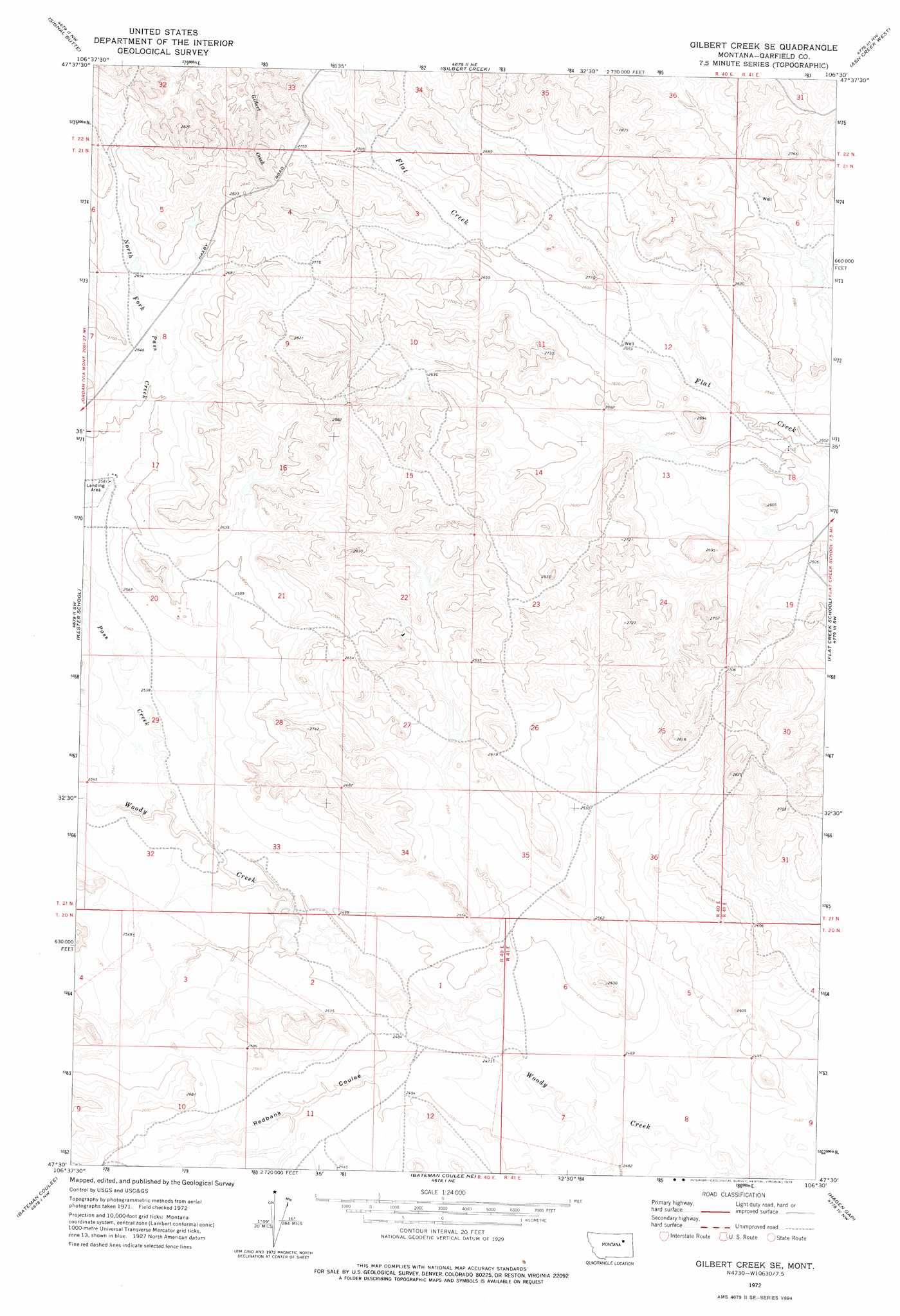
USGS Topo Quad 47106e5 - 1:24,000 scale
| Topo Map Name: | Gilbert Creek Se |
| USGS Topo Quad ID: | 47106e5 |
| Print Size: | ca. 21 1/4" wide x 27" high |
| Southeast Coordinates: | 47.5° N latitude / 106.5° W longitude |
| Map Center Coordinates: | 47.5625° N latitude / 106.5625° W longitude |
| U.S. State: | MT |
| Filename: | o47106e5.jpg |
| Download Map JPG Image: | Gilbert Creek Se topo map 1:24,000 scale |
| Map Type: | Topographic |
| Topo Series: | 7.5´ |
| Map Scale: | 1:24,000 |
| Source of Map Images: | United States Geological Survey (USGS) |
| Alternate Map Versions: |
Gilbert Creek SE MT 1972, updated 1975 Download PDF Buy paper map Gilbert Creek SE MT 2011 Download PDF Buy paper map Gilbert Creek SE MT 2014 Download PDF Buy paper map |
1:24,000 Topo Quads surrounding Gilbert Creek Se
Middle Eighth Coulee |
Seventh Point Buttes |
Sage Creek Point |
Norville Creek |
Spring Creek Bay |
Little Buffalo Hill |
Signal Butte |
Gilbert Creek |
Ash Creek West |
Ash Creek East |
Buffalo Hill |
Kester School |
Gilbert Creek Se |
Flat Creek School |
Short Creek |
Jordan Ne |
Bateman Coulee |
Bateman Coulee Ne |
Hagen Gap |
Frank Coulee |
Jordan Se |
Black John Coulee |
Ada Creek |
Maxwell Coulee |
Coal Creek |
> Back to 47106e1 at 1:100,000 scale
> Back to 47106a1 at 1:250,000 scale
> Back to U.S. Topo Maps home
Gilbert Creek Se topo map: Gazetteer
Gilbert Creek Se: Dams
Barclay Dam elevation 773m 2536′Caldwell Dam elevation 778m 2552′
Caldwell Number 5 Dam elevation 797m 2614′
California Number 1 Dam elevation 775m 2542′
Chocolate Milkshake Dam elevation 803m 2634′
Rey Dam elevation 809m 2654′
Taylor Dam elevation 776m 2545′
Gilbert Creek Se: Populated Places
Phon (historical) elevation 757m 2483′Gilbert Creek Se: Post Offices
Davidson Post Office (historical) elevation 802m 2631′Phon Post Office (historical) elevation 757m 2483′
Randolph Post Office (historical) elevation 796m 2611′
Gilbert Creek Se: Streams
Pass Creek elevation 763m 2503′Gilbert Creek Se: Valleys
Redbank Coulee elevation 750m 2460′Gilbert Creek Se: Wells
18N40E12CCAD01 Well elevation 802m 2631′20N40E12B___01 Well elevation 758m 2486′
21N40E25BBA_01 Well elevation 809m 2654′
21N41E18A___01 Well elevation 761m 2496′
Gilbert Creek Se digital topo map on disk
Buy this Gilbert Creek Se topo map showing relief, roads, GPS coordinates and other geographical features, as a high-resolution digital map file on DVD:
Eastern Montana & Western North Dakota
Buy digital topo maps: Eastern Montana & Western North Dakota