Maloney Hill Topo Map Montana
To zoom in, hover over the map of Maloney Hill
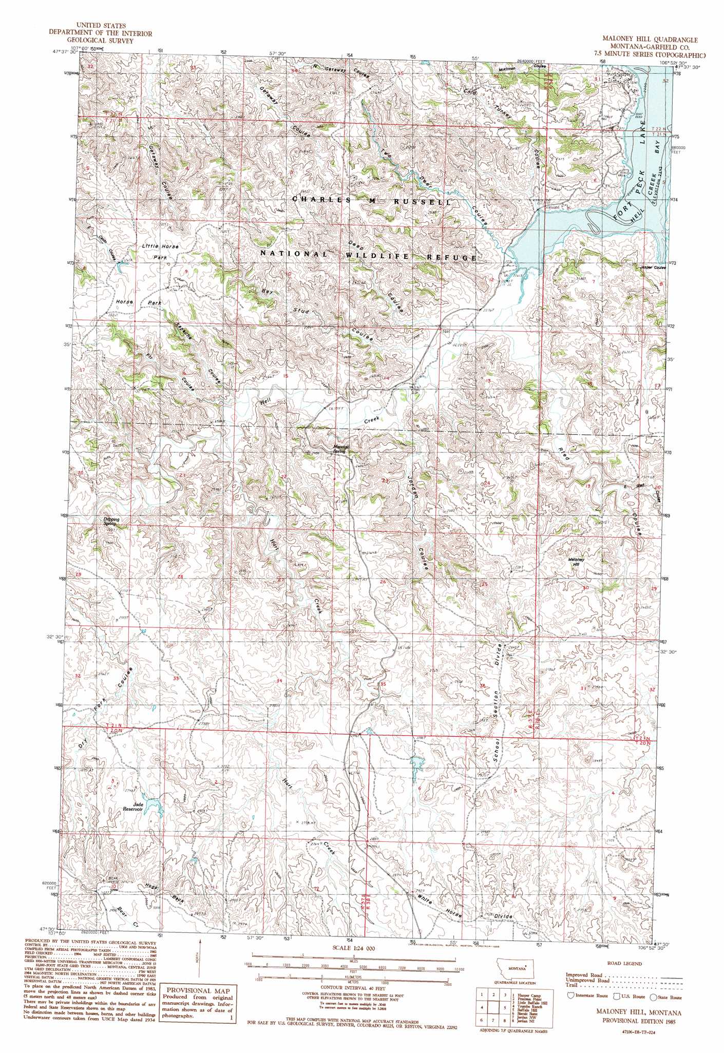
USGS Topo Quad 47106e8 - 1:24,000 scale
| Topo Map Name: | Maloney Hill |
| USGS Topo Quad ID: | 47106e8 |
| Print Size: | ca. 21 1/4" wide x 27" high |
| Southeast Coordinates: | 47.5° N latitude / 106.875° W longitude |
| Map Center Coordinates: | 47.5625° N latitude / 106.9375° W longitude |
| U.S. State: | MT |
| Filename: | o47106e8.jpg |
| Download Map JPG Image: | Maloney Hill topo map 1:24,000 scale |
| Map Type: | Topographic |
| Topo Series: | 7.5´ |
| Map Scale: | 1:24,000 |
| Source of Map Images: | United States Geological Survey (USGS) |
| Alternate Map Versions: |
Maloney Hill MT 1985, updated 1986 Download PDF Buy paper map Maloney Hill MT 2011 Download PDF Buy paper map Maloney Hill MT 2014 Download PDF Buy paper map |
1:24,000 Topo Quads surrounding Maloney Hill
Gibson Coulee |
Murray Hill |
Brown Pass |
Middle Eighth Coulee |
Seventh Point Buttes |
Wagon Coulee |
Harper Camp |
Peterson Point |
Little Buffalo Hill |
Signal Butte |
Hell Hollow |
Trumbo Ranch |
Maloney Hill |
Buffalo Hill |
Kester School |
Moonlight Creek |
Biscuit Butte |
Jordan Nw |
Jordan Ne |
Bateman Coulee |
Smoky Butte Creek |
Smoky Butte |
Jordan |
Jordan Se |
Black John Coulee |
> Back to 47106e1 at 1:100,000 scale
> Back to 47106a1 at 1:250,000 scale
> Back to U.S. Topo Maps home
Maloney Hill topo map: Gazetteer
Maloney Hill: Flats
Horse Park elevation 835m 2739′Little Horse Park elevation 847m 2778′
Maloney Hill: Parks
Hell Creek Recreation Area elevation 699m 2293′Hell Creek State Park elevation 713m 2339′
Maloney Hill: Reservoirs
Jade Reservoir elevation 829m 2719′Maloney Hill: Ridges
Hogs Back elevation 916m 3005′School Section Divide elevation 874m 2867′
White Horse Divide elevation 885m 2903′
Maloney Hill: Springs
Dripping Spring elevation 767m 2516′Manaige Spring elevation 779m 2555′
Maloney Hill: Streams
Hart Creek elevation 712m 2335′Hell Creek elevation 685m 2247′
Maloney Hill: Summits
Maloney Hill elevation 812m 2664′Maloney Hill: Valleys
Bay Stud Coulee elevation 691m 2267′Cold Turkey Coulee elevation 686m 2250′
Deep Coulee elevation 687m 2253′
East Ried Coulee elevation 725m 2378′
Fir Coulee elevation 713m 2339′
Jasper Coulee elevation 686m 2250′
Jordan Coulee elevation 704m 2309′
Kapache Coulee elevation 709m 2326′
Ried Coulee elevation 685m 2247′
Two Deer Coulee elevation 686m 2250′
Maloney Hill digital topo map on disk
Buy this Maloney Hill topo map showing relief, roads, GPS coordinates and other geographical features, as a high-resolution digital map file on DVD:
Eastern Montana & Western North Dakota
Buy digital topo maps: Eastern Montana & Western North Dakota