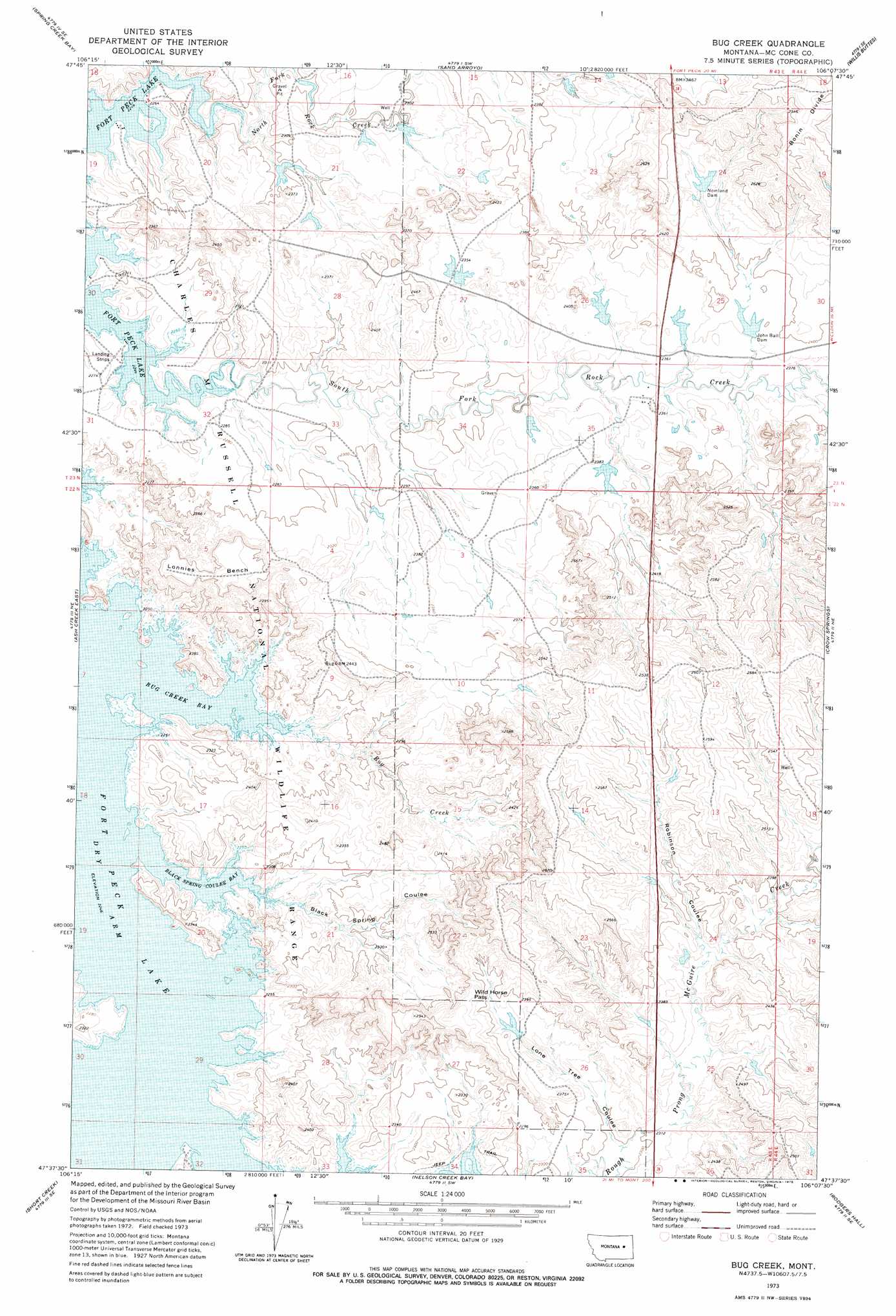
Bug Creek Topo Map Montana
To zoom in, hover over the map of Bug Creek
USGS Topo Quad 47106f2 - 1:24,000 scale
| Topo Map Name: | Bug Creek |
| USGS Topo Quad ID: | 47106f2 |
| Print Size: | ca. 21 1/4" wide x 27" high |
| Southeast Coordinates: | 47.625° N latitude / 106.125° W longitude |
| Map Center Coordinates: | 47.6875° N latitude / 106.1875° W longitude |
| U.S. State: | MT |
| Filename: | o47106f2.jpg |
| Download Map JPG Image: | Bug Creek topo map 1:24,000 scale |
| Map Type: | Topographic |
| Topo Series: | 7.5´ |
| Map Scale: | 1:24,000 |
| Source of Map Images: | United States Geological Survey (USGS) |
| Alternate Map Versions: |
Bug Creek MT 1973, updated 1978 Download PDF Buy paper map Bug Creek MT 2011 Download PDF Buy paper map Bug Creek MT 2014 Download PDF Buy paper map |
1:24,000 Topo Quads surrounding Bug Creek
York Island |
Bobcat Creek |
Mcrae Springs |
Pasture Creek |
Turtle Creek |
Norville Creek |
Spring Creek Bay |
Sand Arroyo |
Willis Buttes |
Shade Creek |
Ash Creek West |
Ash Creek East |
Bug Creek |
Crow Springs |
Figure Eight Creek |
Flat Creek School |
Short Creek |
Nelson Creek Bay |
Rodgers Hall |
Weldon |
Hagen Gap |
Frank Coulee |
Fortyfour Coulee |
Johnson Coulee West |
Johnson Coulee East |
> Back to 47106e1 at 1:100,000 scale
> Back to 47106a1 at 1:250,000 scale
> Back to U.S. Topo Maps home
Bug Creek topo map: Gazetteer
Bug Creek: Bays
Black Spring Coulee Bay elevation 686m 2250′Bug Creek Bay elevation 686m 2250′
Bug Creek: Benches
Lonnies Bench elevation 741m 2431′Bug Creek: Capes
Daniels Point elevation 700m 2296′Bug Creek: Dams
Bug Dam elevation 723m 2372′John Ball Dam elevation 724m 2375′
John Ball Reservoir Dam elevation 724m 2375′
Lyle Nelson Number 1 Dam elevation 696m 2283′
Lyle Nelson Number 3 Dam elevation 704m 2309′
Lyle Nelson Number 5 Dam elevation 716m 2349′
Lyle Nelson Number 6 Dam elevation 717m 2352′
Nelson Reservoir Number 2 Dam elevation 727m 2385′
Nomland Dam elevation 740m 2427′
Nomland Dam elevation 741m 2431′
Towe Farms Number 1 Dam elevation 708m 2322′
Towe Farms Number 2 Dam elevation 719m 2358′
Bug Creek: Gaps
Wild Horse Pass elevation 754m 2473′Bug Creek: Reservoirs
John Ball Reservoir elevation 724m 2375′Bug Creek: Streams
Bug Creek elevation 686m 2250′North Fork Rock Creek elevation 689m 2260′
South Fork Rock Creek elevation 686m 2250′
Bug Creek: Valleys
Black Spring Coulee elevation 686m 2250′Lone Tree Coulee elevation 700m 2296′
Robinson Coulee elevation 719m 2358′
Bug Creek: Wells
22N43E03ACAD01 Well elevation 708m 2322′22N44E18BB__01 Well elevation 773m 2536′
23N43E21AAAB01 Well elevation 700m 2296′
23N43E34BABC01 Well elevation 706m 2316′
Bug Creek digital topo map on disk
Buy this Bug Creek topo map showing relief, roads, GPS coordinates and other geographical features, as a high-resolution digital map file on DVD:
Eastern Montana & Western North Dakota
Buy digital topo maps: Eastern Montana & Western North Dakota