Sand Arroyo Topo Map Montana
To zoom in, hover over the map of Sand Arroyo
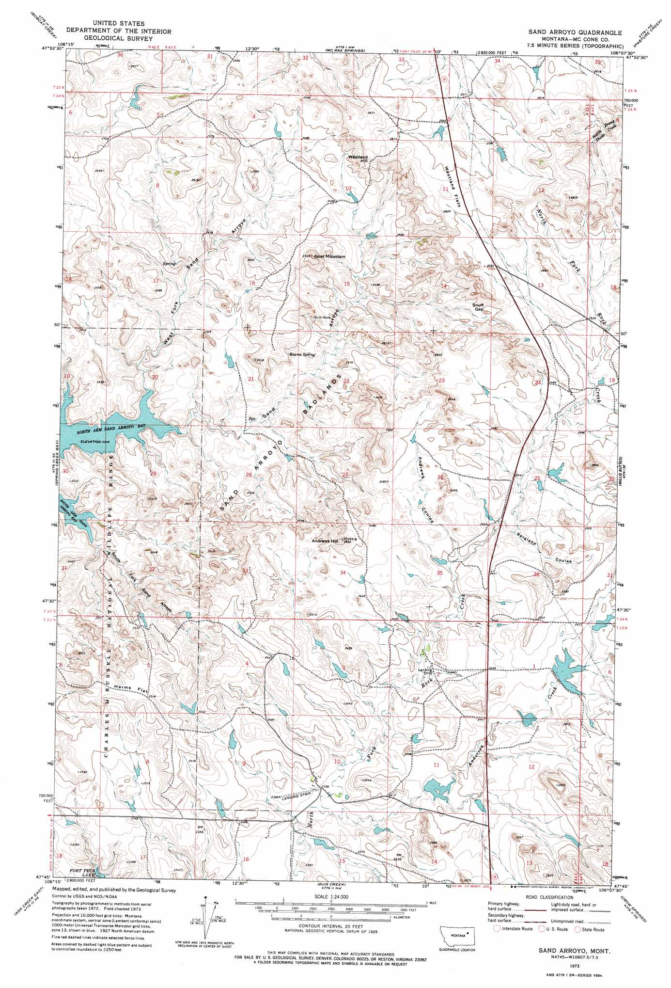
USGS Topo Quad 47106g2 - 1:24,000 scale
| Topo Map Name: | Sand Arroyo |
| USGS Topo Quad ID: | 47106g2 |
| Print Size: | ca. 21 1/4" wide x 27" high |
| Southeast Coordinates: | 47.75° N latitude / 106.125° W longitude |
| Map Center Coordinates: | 47.8125° N latitude / 106.1875° W longitude |
| U.S. State: | MT |
| Filename: | o47106g2.jpg |
| Download Map JPG Image: | Sand Arroyo topo map 1:24,000 scale |
| Map Type: | Topographic |
| Topo Series: | 7.5´ |
| Map Scale: | 1:24,000 |
| Source of Map Images: | United States Geological Survey (USGS) |
| Alternate Map Versions: |
Sand Arroyo MT 1973, updated 1977 Download PDF Buy paper map Sand Arroyo MT 2011 Download PDF Buy paper map Sand Arroyo MT 2014 Download PDF Buy paper map |
1:24,000 Topo Quads surrounding Sand Arroyo
Fort Peck |
Milk River Hills |
Kintyre |
Frazer |
Oswego |
York Island |
Bobcat Creek |
Mcrae Springs |
Pasture Creek |
Turtle Creek |
Norville Creek |
Spring Creek Bay |
Sand Arroyo |
Willis Buttes |
Shade Creek |
Ash Creek West |
Ash Creek East |
Bug Creek |
Crow Springs |
Figure Eight Creek |
Flat Creek School |
Short Creek |
Nelson Creek Bay |
Rodgers Hall |
Weldon |
> Back to 47106e1 at 1:100,000 scale
> Back to 47106a1 at 1:250,000 scale
> Back to U.S. Topo Maps home
Sand Arroyo topo map: Gazetteer
Sand Arroyo: Airports
Nelson Airport elevation 717m 2352′Sand Arroyo: Areas
Sand Arroyo Badlands elevation 723m 2372′Sand Arroyo: Bays
North Arm Sand Arroyo Bay elevation 686m 2250′Sand Arroyo: Dams
Lyle Nelson Number 7 Dam elevation 759m 2490′Lyle Nelson Number 8 Dam elevation 724m 2375′
Nelson Number 1 Dam elevation 742m 2434′
Nelson Number 2 Dam elevation 736m 2414′
Thora Number 2 Dam elevation 748m 2454′
Sand Arroyo: Flats
Harms Flat elevation 778m 2552′Westland Flats elevation 805m 2641′
Sand Arroyo: Gaps
Snuff Gap elevation 761m 2496′Sand Arroyo: Post Offices
Bonin Post Office (historical) elevation 707m 2319′Sand Arroyo: Springs
Reaves Spring elevation 733m 2404′Sand Arroyo: Streams
Anderson Creek elevation 713m 2339′Sand Arroyo: Summits
Andrews Hill elevation 792m 2598′Goat Mountain elevation 810m 2657′
Westland Hill elevation 808m 2650′
Sand Arroyo: Valleys
Andrews Coulee elevation 727m 2385′Bergland Coulee elevation 737m 2417′
Sand Arroyo elevation 696m 2283′
South Fork Sand Arroyo elevation 696m 2283′
West Fork Sand Arroyo elevation 686m 2250′
Sand Arroyo: Wells
23N43E02DABA01 Well elevation 740m 2427′Sand Arroyo digital topo map on disk
Buy this Sand Arroyo topo map showing relief, roads, GPS coordinates and other geographical features, as a high-resolution digital map file on DVD:
Eastern Montana & Western North Dakota
Buy digital topo maps: Eastern Montana & Western North Dakota