Seventynine Coulee Topo Map Montana
To zoom in, hover over the map of Seventynine Coulee
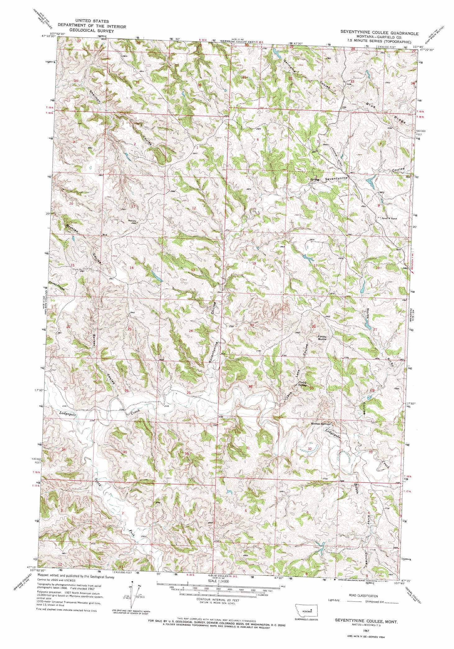
USGS Topo Quad 47107c7 - 1:24,000 scale
| Topo Map Name: | Seventynine Coulee |
| USGS Topo Quad ID: | 47107c7 |
| Print Size: | ca. 21 1/4" wide x 27" high |
| Southeast Coordinates: | 47.25° N latitude / 107.75° W longitude |
| Map Center Coordinates: | 47.3125° N latitude / 107.8125° W longitude |
| U.S. State: | MT |
| Filename: | o47107c7.jpg |
| Download Map JPG Image: | Seventynine Coulee topo map 1:24,000 scale |
| Map Type: | Topographic |
| Topo Series: | 7.5´ |
| Map Scale: | 1:24,000 |
| Source of Map Images: | United States Geological Survey (USGS) |
| Alternate Map Versions: |
Seventynine Coulee MT 1967, updated 1971 Download PDF Buy paper map Seventynine Coulee MT 2011 Download PDF Buy paper map Seventynine Coulee MT 2014 Download PDF Buy paper map |
1:24,000 Topo Quads surrounding Seventynine Coulee
Chain Buttes |
Locke Ranch |
Mickey Butte |
Lost Creek |
Pine Grove School |
Weingart Place |
Germaine Coulee West |
Germaine Coulee East |
Cap Rock Butte |
Spring Creek School |
Kirkendal Flat |
Nelson Coulee |
Seventynine Coulee |
Benzien |
Hay Coulee |
Tin Can Hill |
Bridge Coulee |
Lelig Coulee |
Searl Coulee |
Coffin Butte |
Cat Creek |
Fail Ranch |
Barney Pinnacle |
Froehlich Butte |
Cox Butte |
> Back to 47107a1 at 1:100,000 scale
> Back to 47106a1 at 1:250,000 scale
> Back to U.S. Topo Maps home
Seventynine Coulee topo map: Gazetteer
Seventynine Coulee: Dams
Field Number 1 Dam elevation 875m 2870′Matovich Number 1 Dam elevation 829m 2719′
Seventynine Coulee: Springs
Finley Spring elevation 802m 2631′Herron Springs elevation 782m 2565′
Seventynine Coulee: Streams
Seventy Nine Creek elevation 746m 2447′South Fork Lodgepole Creek elevation 726m 2381′
Seventynine Coulee: Summits
Finley Butte elevation 892m 2926′Seventynine Coulee: Valleys
Barker Coulee elevation 733m 2404′Jack Lane Coulee elevation 759m 2490′
North Kirby Coulee elevation 792m 2598′
Seventynine Coulee elevation 749m 2457′
South Kirby Coulee elevation 788m 2585′
Seventynine Coulee: Wells
18N31E08ACAB01 Well elevation 863m 2831′Seventynine Coulee digital topo map on disk
Buy this Seventynine Coulee topo map showing relief, roads, GPS coordinates and other geographical features, as a high-resolution digital map file on DVD:
Eastern Montana & Western North Dakota
Buy digital topo maps: Eastern Montana & Western North Dakota