Pea Ridge Topo Map Montana
To zoom in, hover over the map of Pea Ridge
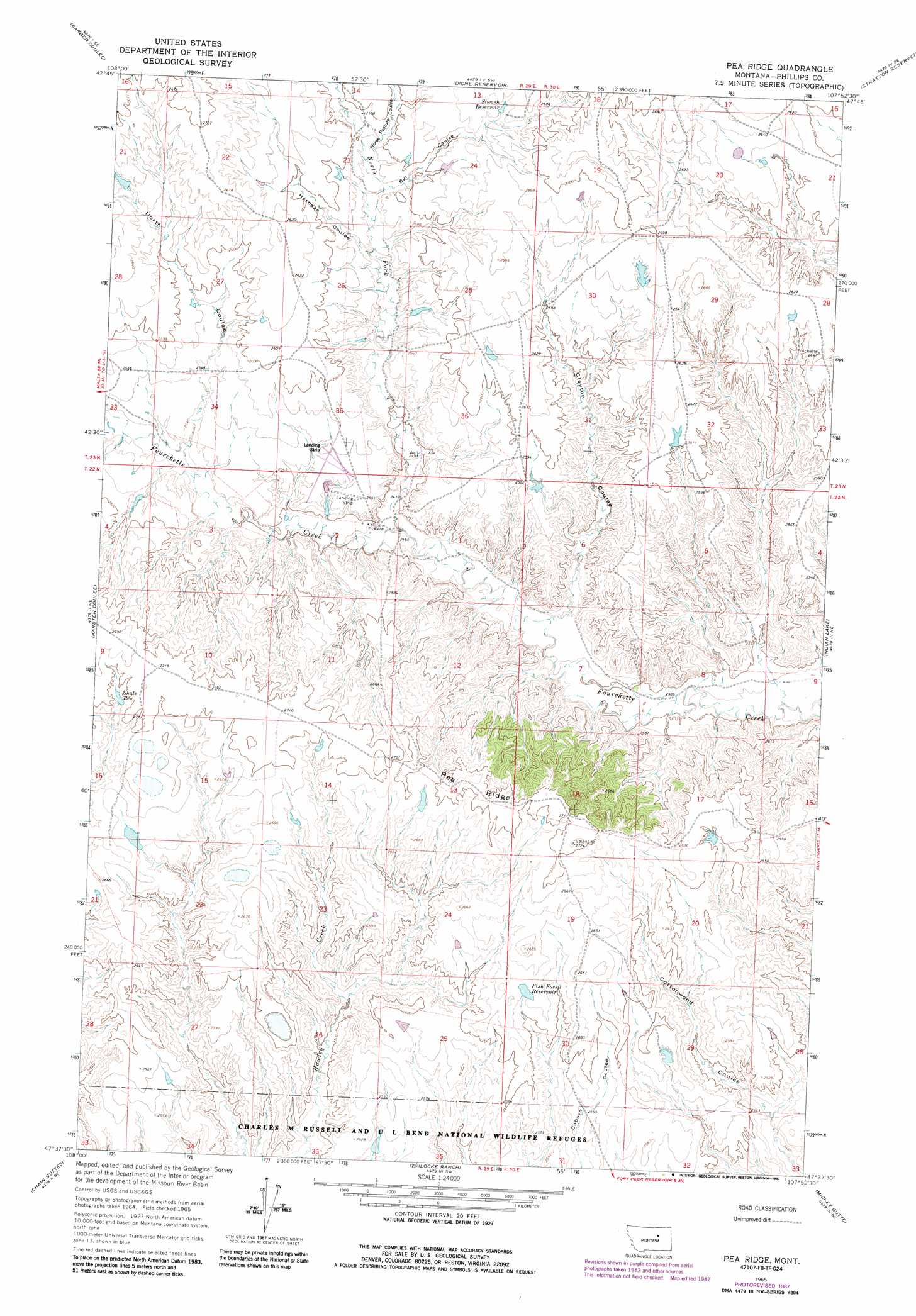
USGS Topo Quad 47107f8 - 1:24,000 scale
| Topo Map Name: | Pea Ridge |
| USGS Topo Quad ID: | 47107f8 |
| Print Size: | ca. 21 1/4" wide x 27" high |
| Southeast Coordinates: | 47.625° N latitude / 107.875° W longitude |
| Map Center Coordinates: | 47.6875° N latitude / 107.9375° W longitude |
| U.S. State: | MT |
| Filename: | o47107f8.jpg |
| Download Map JPG Image: | Pea Ridge topo map 1:24,000 scale |
| Map Type: | Topographic |
| Topo Series: | 7.5´ |
| Map Scale: | 1:24,000 |
| Source of Map Images: | United States Geological Survey (USGS) |
| Alternate Map Versions: |
Pea Ridge MT 1965, updated 1970 Download PDF Buy paper map Pea Ridge MT 1965, updated 1987 Download PDF Buy paper map Pea Ridge MT 2011 Download PDF Buy paper map Pea Ridge MT 2014 Download PDF Buy paper map |
1:24,000 Topo Quads surrounding Pea Ridge
Veseth Reservoir |
Holzhey Reservoir |
Emond Ranch |
Whitcomb Lake |
Sheep Coulee |
Dry Fork Ridge |
Barber Coulee |
Dione Reservoir |
Stratton Reservoir |
Sun Prairie |
Lake Reservoir |
Karsten Coulee |
Pea Ridge |
Indian Lake |
Herman Point |
Dry Coulee |
Chain Buttes |
Locke Ranch |
Mickey Butte |
Lost Creek |
Weingart Place Nw |
Weingart Place |
Germaine Coulee West |
Germaine Coulee East |
Cap Rock Butte |
> Back to 47107e1 at 1:100,000 scale
> Back to 47106a1 at 1:250,000 scale
> Back to U.S. Topo Maps home
Pea Ridge topo map: Gazetteer
Pea Ridge: Dams
Pea Ridge Number 1 Dam elevation 802m 2631′Pea Ridge: Populated Places
Fourchette (historical) elevation 801m 2627′Pea Ridge: Post Offices
Fourchette Post Office (historical) elevation 801m 2627′Pea Ridge: Reservoirs
Fish Fossil Reservoir elevation 800m 2624′Shale Reservoir elevation 820m 2690′
Siwash Reservoir elevation 810m 2657′
Pea Ridge: Ridges
Pea Ridge elevation 830m 2723′Pea Ridge: Streams
North Fork Fourchette Creek elevation 751m 2463′Pea Ridge: Valleys
Bur Coulee elevation 785m 2575′Clayton Coulee elevation 744m 2440′
Hardpan Coulee elevation 776m 2545′
Horse Pasture Coulee elevation 786m 2578′
North Coulee elevation 769m 2522′
Pea Ridge: Wells
22N29E01BB__01 Well elevation 776m 2545′22N29E01DBCC01 Well elevation 745m 2444′
22N29E02AD__01 Well elevation 751m 2463′
22N29E02ADD_01 Well elevation 760m 2493′
22N30E07DA__01 Well elevation 732m 2401′
23N29E23ABC_01 Well elevation 791m 2595′
23N29E35DC__01 Well elevation 779m 2555′
Pea Ridge digital topo map on disk
Buy this Pea Ridge topo map showing relief, roads, GPS coordinates and other geographical features, as a high-resolution digital map file on DVD:
Eastern Montana & Western North Dakota
Buy digital topo maps: Eastern Montana & Western North Dakota