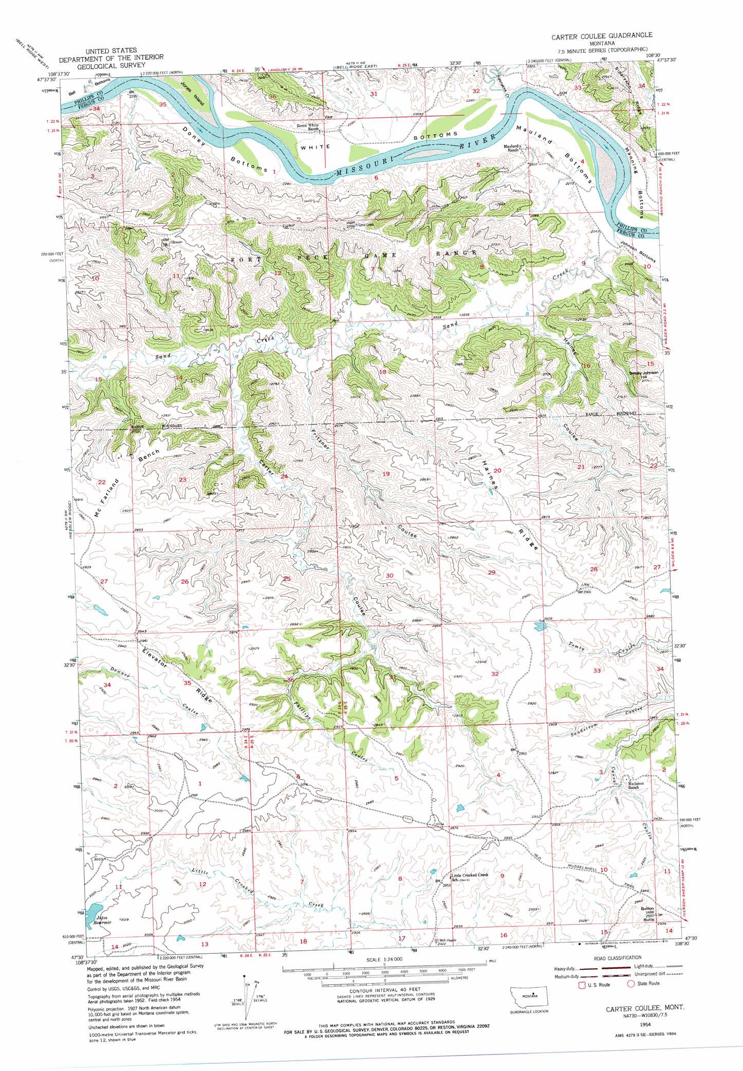
Carter Coulee Topo Map Montana
To zoom in, hover over the map of Carter Coulee
USGS Topo Quad 47108e5 - 1:24,000 scale
| Topo Map Name: | Carter Coulee |
| USGS Topo Quad ID: | 47108e5 |
| Print Size: | ca. 21 1/4" wide x 27" high |
| Southeast Coordinates: | 47.5° N latitude / 108.5° W longitude |
| Map Center Coordinates: | 47.5625° N latitude / 108.5625° W longitude |
| U.S. State: | MT |
| Filename: | o47108e5.jpg |
| Download Map JPG Image: | Carter Coulee topo map 1:24,000 scale |
| Map Type: | Topographic |
| Topo Series: | 7.5´ |
| Map Scale: | 1:24,000 |
| Source of Map Images: | United States Geological Survey (USGS) |
| Alternate Map Versions: |
Carter Coulee MT 1954, updated 1956 Download PDF Buy paper map Carter Coulee MT 1954, updated 1976 Download PDF Buy paper map Carter Coulee MT 2011 Download PDF Buy paper map Carter Coulee MT 2014 Download PDF Buy paper map |
1:24,000 Topo Quads surrounding Carter Coulee
Shetland Divide |
D Y Junction |
Hays Se |
Robinson School |
Bison Bone Reservoir |
Grand Island |
Bell Ridge West |
Bell Ridge East |
Sagebrush Reservoir |
Blizzard Reservoir |
Mitchell Crossing |
Hessler Ridge |
Carter Coulee |
Kepple Bottoms |
Hanson Flat |
Griffee Coulee |
Sloan Reservoir |
Kachia Reservoir |
Pipes Coulee |
Dovetail Butte |
Bohemian Corners |
Bear Creek Reservoir |
Bear Creek Reservoir Se |
Valentine |
Brown Spring |
> Back to 47108e1 at 1:100,000 scale
> Back to 47108a1 at 1:250,000 scale
> Back to U.S. Topo Maps home
Carter Coulee topo map: Gazetteer
Carter Coulee: Benches
Mc Farland Bench elevation 865m 2837′Carter Coulee: Bends
Bell Bottoms elevation 691m 2267′Doney Bottoms elevation 690m 2263′
Mauland Bottoms elevation 689m 2260′
White Bottoms elevation 690m 2263′
Carter Coulee: Dams
Cimrhakl Number 4 Dam elevation 892m 2926′Dutch Dam elevation 891m 2923′
Jakes Dam elevation 915m 3001′
Carter Coulee: Islands
Jones Island elevation 686m 2250′Carter Coulee: Mines
Apex Number 2 Mine elevation 834m 2736′Carter Coulee: Populated Places
Little Crooked (historical) elevation 900m 2952′Carter Coulee: Post Offices
Little Crooked Post Office (historical) elevation 900m 2952′Carter Coulee: Reservoirs
Jakes Reservoir elevation 915m 3001′Carter Coulee: Ridges
Elevator Ridge elevation 902m 2959′Haines Ridge elevation 879m 2883′
Carter Coulee: Streams
Duval Creek elevation 691m 2267′Sand Creek elevation 689m 2260′
Siparyann Creek elevation 689m 2260′
Carter Coulee: Summits
Button Butte elevation 904m 2965′Smoky Johnson Hill elevation 843m 2765′
Carter Coulee: Valleys
Carter Coulee elevation 728m 2388′Fritzner Coulee elevation 723m 2372′
Haines Coulee elevation 704m 2309′
Phillips Coulee elevation 819m 2687′
Carter Coulee: Wells
21N24E01AA__01 Well elevation 691m 2267′21N24E13BA__01 Well elevation 728m 2388′
Carter Coulee digital topo map on disk
Buy this Carter Coulee topo map showing relief, roads, GPS coordinates and other geographical features, as a high-resolution digital map file on DVD: