Coburn Butte Topo Map Montana
To zoom in, hover over the map of Coburn Butte
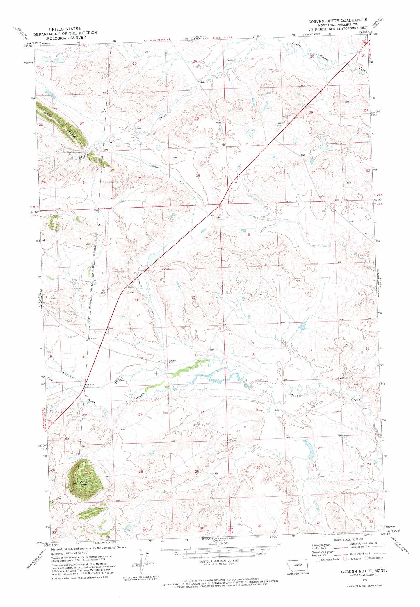
USGS Topo Quad 47108h3 - 1:24,000 scale
| Topo Map Name: | Coburn Butte |
| USGS Topo Quad ID: | 47108h3 |
| Print Size: | ca. 21 1/4" wide x 27" high |
| Southeast Coordinates: | 47.875° N latitude / 108.25° W longitude |
| Map Center Coordinates: | 47.9375° N latitude / 108.3125° W longitude |
| U.S. State: | MT |
| Filename: | o47108h3.jpg |
| Download Map JPG Image: | Coburn Butte topo map 1:24,000 scale |
| Map Type: | Topographic |
| Topo Series: | 7.5´ |
| Map Scale: | 1:24,000 |
| Source of Map Images: | United States Geological Survey (USGS) |
| Alternate Map Versions: |
Coburn Butte MT 1971, updated 1974 Download PDF Buy paper map Coburn Butte MT 2011 Download PDF Buy paper map Coburn Butte MT 2014 Download PDF Buy paper map |
1:24,000 Topo Quads surrounding Coburn Butte
Lodge Pole Ne |
Big Flat West |
Big Flat East |
Wild Horse Reservoir |
West Alkali Reservoir |
Lodge Pole |
Ball Coulee |
Ester Lake |
Phillips |
Seymour Reservoir |
Zortman |
Bear Mountain |
Coburn Butte |
Veseth Reservoir |
Holzhey Reservoir |
Hays Se |
Robinson School |
Bison Bone Reservoir |
Dry Fork Ridge |
Barber Coulee |
Bell Ridge East |
Sagebrush Reservoir |
Blizzard Reservoir |
Lake Reservoir |
Karsten Coulee |
> Back to 47108e1 at 1:100,000 scale
> Back to 47108a1 at 1:250,000 scale
> Back to U.S. Topo Maps home
Coburn Butte topo map: Gazetteer
Coburn Butte: Canals
Coburn Ditch elevation 921m 3021′Coburn Butte: Dams
Matador Ranch Number 3 Dam elevation 894m 2933′Matador Ranch Number 4 Dam elevation 900m 2952′
Matador Ranch Number 6 Dam elevation 886m 2906′
Matador Ranch Number 8 Dam elevation 883m 2896′
Coburn Butte: Streams
Baker Creek elevation 933m 3061′Coburn Butte: Summits
Coburn Butte elevation 1154m 3786′Coburn Butte: Valleys
Bear Gulch elevation 903m 2962′Best Coulee elevation 846m 2775′
Coburn Butte: Wells
25N26E15CCCA01 Well elevation 933m 3061′25N26E15CDC_01 Well elevation 929m 3047′
25N26E22BBBB01 Well elevation 933m 3061′
26N26E27DDBC01 Well elevation 928m 3044′
26N26E33AAA_01 Well elevation 959m 3146′
26N26E33AAA_02 Well elevation 959m 3146′
Coburn Butte digital topo map on disk
Buy this Coburn Butte topo map showing relief, roads, GPS coordinates and other geographical features, as a high-resolution digital map file on DVD: