Pike Creek Topo Map Montana
To zoom in, hover over the map of Pike Creek
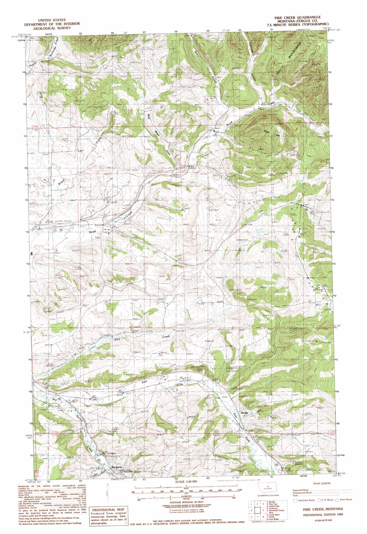
USGS Topo Quad 47109a3 - 1:24,000 scale
| Topo Map Name: | Pike Creek |
| USGS Topo Quad ID: | 47109a3 |
| Print Size: | ca. 21 1/4" wide x 27" high |
| Southeast Coordinates: | 47° N latitude / 109.25° W longitude |
| Map Center Coordinates: | 47.0625° N latitude / 109.3125° W longitude |
| U.S. State: | MT |
| Filename: | o47109a3.jpg |
| Download Map JPG Image: | Pike Creek topo map 1:24,000 scale |
| Map Type: | Topographic |
| Topo Series: | 7.5´ |
| Map Scale: | 1:24,000 |
| Source of Map Images: | United States Geological Survey (USGS) |
| Alternate Map Versions: |
Pike Creek MT 1985, updated 1986 Download PDF Buy paper map Pike Creek MT 2011 Download PDF Buy paper map Pike Creek MT 2014 Download PDF Buy paper map |
1:24,000 Topo Quads surrounding Pike Creek
Seventytwo Hills |
Kendall |
Hilger |
Armells |
Fergus |
Spring Creek Junction |
Brooks |
New Year |
Judith Peak |
Lewis Peak |
Glengarry |
Lewistown |
Pike Creek |
Horsethief Coulee W. |
Horsethief Coulee E. |
West Fork Beaver Creek |
Castle Butte |
Heath |
Loco Ridge |
Forestgrove |
Crystal Lake |
Jump Off Peak |
Half Moon Canyon |
Alaska Bench |
South Bench |
> Back to 47109a1 at 1:100,000 scale
> Back to 47108a1 at 1:250,000 scale
> Back to U.S. Topo Maps home
Pike Creek topo map: Gazetteer
Pike Creek: Dams
Pike Creek Dam elevation 1286m 4219′Pike Creek: Mines
Brown Coal Mine elevation 1432m 4698′Divide Coal Mine elevation 1432m 4698′
Skaggs Coal Mine elevation 1381m 4530′
Pike Creek: Populated Places
Box Springs (historical) elevation 1265m 4150′Corbly (historical) elevation 1270m 4166′
Ruby Gulch (historical) elevation 1380m 4527′
Pike Creek: Springs
14N19E05CAA_01 Spring elevation 1273m 4176′14N19E05DBC_01 Spring elevation 1276m 4186′
14N19E05DBCC01 Spring elevation 1275m 4183′
Big Spring elevation 1269m 4163′
Pike Creek: Streams
Castle Creek elevation 1269m 4163′East Fork Big Spring Creek elevation 1245m 4084′
Hansen Creek elevation 1267m 4156′
Pike Creek elevation 1236m 4055′
Pyramid Creek elevation 1398m 4586′
Pike Creek: Summits
Kelly Hill elevation 1631m 5351′Pike Creek: Valleys
Blind Breed Gulch elevation 1306m 4284′Limekiln Canyon elevation 1366m 4481′
Ruby Gulch elevation 1343m 4406′
Pike Creek: Wells
14N19E01CBAD01 Well elevation 1393m 4570′15N19E08ACCA01 Well elevation 1304m 4278′
15N19E08CCBA01 Well elevation 1282m 4206′
15N19E08DCCA01 Well elevation 1269m 4163′
15N19E08DDA_01 Well elevation 1282m 4206′
15N19E09BABC01 Well elevation 1300m 4265′
15N19E17BABD01 Well elevation 1263m 4143′
15N19E17BBA_01 Well elevation 1260m 4133′
15N19E18CBBD01 Well elevation 1261m 4137′
15N19E24BC__01 Well elevation 1433m 4701′
15N19E25BDAB01 Well elevation 1510m 4954′
15N19E26BCBC01 Well elevation 1354m 4442′
15N19E30CCDA01 Well elevation 1274m 4179′
15N19E32CCC_01 Well elevation 1290m 4232′
15N19E35ACCB01 Well elevation 1377m 4517′
15N19E35BDBD01 Well elevation 1370m 4494′
15N19E35DACB01 Well elevation 1349m 4425′
15N19E35DBBC01 Well elevation 1380m 4527′
16N19E31CAA_01 Well elevation 1308m 4291′
16N19E34ADCA01 Well elevation 1395m 4576′
16N19E34ADCD01 Well elevation 1370m 4494′
16N19E34B___01 Well elevation 1394m 4573′
Pike Creek digital topo map on disk
Buy this Pike Creek topo map showing relief, roads, GPS coordinates and other geographical features, as a high-resolution digital map file on DVD: