Toney Bench Topo Map Montana
To zoom in, hover over the map of Toney Bench
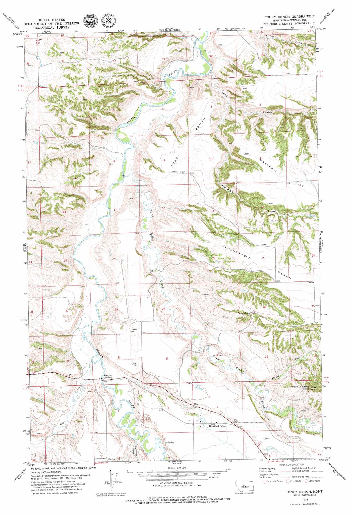
USGS Topo Quad 47109c6 - 1:24,000 scale
| Topo Map Name: | Toney Bench |
| USGS Topo Quad ID: | 47109c6 |
| Print Size: | ca. 21 1/4" wide x 27" high |
| Southeast Coordinates: | 47.25° N latitude / 109.625° W longitude |
| Map Center Coordinates: | 47.3125° N latitude / 109.6875° W longitude |
| U.S. State: | MT |
| Filename: | o47109c6.jpg |
| Download Map JPG Image: | Toney Bench topo map 1:24,000 scale |
| Map Type: | Topographic |
| Topo Series: | 7.5´ |
| Map Scale: | 1:24,000 |
| Source of Map Images: | United States Geological Survey (USGS) |
| Alternate Map Versions: |
Toney Bench MT 1978, updated 1979 Download PDF Buy paper map Toney Bench MT 2011 Download PDF Buy paper map Toney Bench MT 2014 Download PDF Buy paper map |
1:24,000 Topo Quads surrounding Toney Bench
Steele Lake Coulee |
Spring Coulee |
Wolf Creek Falls |
Anderson Bridge |
Winifred West |
Possum Run Creek |
Soda Spring Coulee |
Wild Bill Flat West |
Wild Bill Flat East |
Hilger Nw |
Denton |
Hoosac |
Toney Bench |
Seventytwo Hills |
Kendall |
Big Spring |
Harwood Bench |
Danvers |
Spring Creek Junction |
Brooks |
Moccasin |
Kolin |
Ross Fork |
Glengarry |
Lewistown |
> Back to 47109a1 at 1:100,000 scale
> Back to 47108a1 at 1:250,000 scale
> Back to U.S. Topo Maps home
Toney Bench topo map: Gazetteer
Toney Bench: Benches
Seventytwo Bench elevation 1158m 3799′Toney Bench elevation 1045m 3428′
Toney Bench: Bridges
Samples Crossing Bridge elevation 981m 3218′Toney Bench: Flats
Marshall Flat elevation 1107m 3631′Toney Bench: Populated Places
Deerfield Colony elevation 1050m 3444′Samples Crossing elevation 982m 3221′
Toney Bench: Post Offices
Deerfield Post Office (historical) elevation 1070m 3510′Toney Bench: Streams
Alkali Creek elevation 1018m 3339′Sage Creek elevation 978m 3208′
Warm Spring Creek elevation 949m 3113′
Toney Bench: Summits
Indian Graves Butte elevation 1190m 3904′Sand Rock Hill elevation 1137m 3730′
Toney Bench: Valleys
Hamilton Coulee elevation 951m 3120′Ming Coulee elevation 929m 3047′
Scotchman Coulee elevation 998m 3274′
Toney Bench: Wells
17N16E03ACDD01 Well elevation 1053m 3454′18N16E23CBD_01 Well elevation 1160m 3805′
Toney Bench digital topo map on disk
Buy this Toney Bench topo map showing relief, roads, GPS coordinates and other geographical features, as a high-resolution digital map file on DVD: