Stanford Ne Topo Map Montana
To zoom in, hover over the map of Stanford Ne
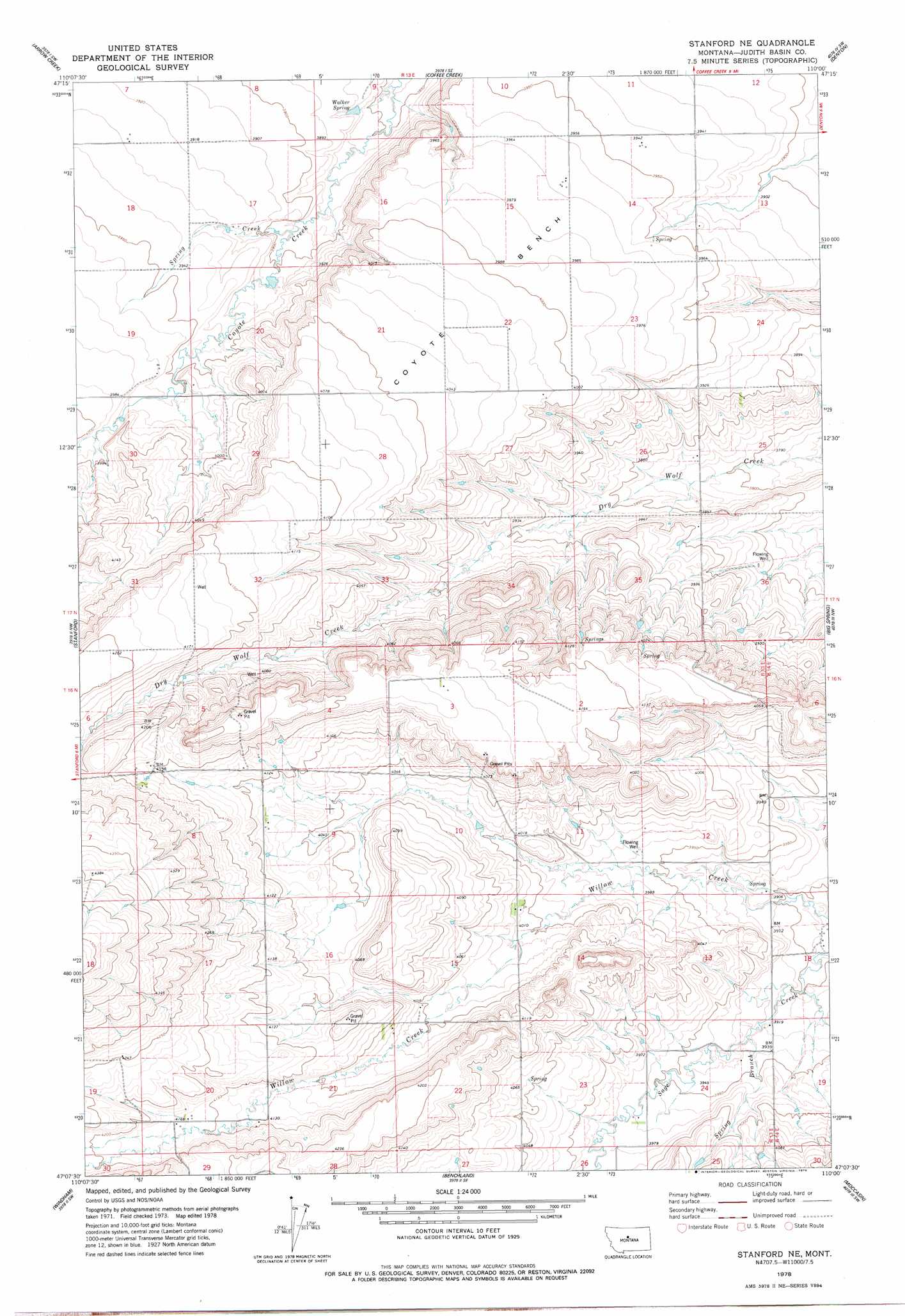
USGS Topo Quad 47110b1 - 1:24,000 scale
| Topo Map Name: | Stanford Ne |
| USGS Topo Quad ID: | 47110b1 |
| Print Size: | ca. 21 1/4" wide x 27" high |
| Southeast Coordinates: | 47.125° N latitude / 110° W longitude |
| Map Center Coordinates: | 47.1875° N latitude / 110.0625° W longitude |
| U.S. State: | MT |
| Filename: | o47110b1.jpg |
| Download Map JPG Image: | Stanford Ne topo map 1:24,000 scale |
| Map Type: | Topographic |
| Topo Series: | 7.5´ |
| Map Scale: | 1:24,000 |
| Source of Map Images: | United States Geological Survey (USGS) |
| Alternate Map Versions: |
Stanford NE MT 1978, updated 1979 Download PDF Buy paper map Stanford NE MT 2011 Download PDF Buy paper map Stanford NE MT 2014 Download PDF Buy paper map |
1:24,000 Topo Quads surrounding Stanford Ne
Jiggs Flat |
Pownal |
Strouf Island |
Possum Run Creek |
Soda Spring Coulee |
Leiberg Coulee |
Arrow Creek |
Coffee Creek |
Denton |
Hoosac |
Merino |
Stanford |
Stanford Ne |
Big Spring |
Harwood Bench |
Cayuse Basin |
Windham |
Benchland |
Moccasin |
Kolin |
Woodhurst Mountain |
Red Hill |
Utica |
Ackley Lake |
Sipple |
> Back to 47110a1 at 1:100,000 scale
> Back to 47110a1 at 1:250,000 scale
> Back to U.S. Topo Maps home
Stanford Ne topo map: Gazetteer
Stanford Ne: Benches
Coyote Bench elevation 1211m 3973′Stanford Ne: Post Offices
Coyote Post Office (historical) elevation 1210m 3969′Lewis Post Office (historical) elevation 1215m 3986′
Stanford Ne: Springs
16N13E12DDD_01 Spring elevation 1192m 3910′Walker Spring elevation 1179m 3868′
Stanford Ne: Streams
Spring Branch elevation 1199m 3933′Spring Creek elevation 1186m 3891′
Stanford Ne: Wells
16N13E01DDBD02 Well elevation 1216m 3989′16N13E05DDD_01 Well elevation 1256m 4120′
16N13E11DADA01 Well elevation 1208m 3963′
16N13E14BBB_01 Well elevation 1223m 4012′
16N13E15CCAD01 Well elevation 1239m 4064′
16N13E15CCC_01 Well elevation 1238m 4061′
16N13E15DAC_01 Well elevation 1231m 4038′
16N13E18AB__01 Well elevation 1361m 4465′
16N13E19AAC_01 Well elevation 1299m 4261′
16N13E19AACD01 Well elevation 1297m 4255′
16N13E20CDB_01 Well elevation 1270m 4166′
16N13E20DDA_01 Well elevation 1263m 4143′
16N13E23AAD_01 Well elevation 1214m 3982′
16N13E23DDA_01 Well elevation 1211m 3973′
16N14E07BBDA01 Well elevation 1203m 3946′
16N14E07BDBB01 Well elevation 1200m 3937′
16N14E07BDDB01 Well elevation 1192m 3910′
16N14E18BDD_01 Well elevation 1185m 3887′
17N13E14ABB_01 Well elevation 1203m 3946′
17N13E14ABB_02 Well elevation 1203m 3946′
17N13E25BAB_01 Well elevation 1186m 3891′
17N13E26ADAD01 Well elevation 1180m 3871′
17N13E26CDC_01 Well elevation 1178m 3864′
17N13E26DAA_01 Well elevation 1167m 3828′
17N13E30DBD_01 Well elevation 1231m 4038′
17N13E32ACD_01 Well elevation 1252m 4107′
17N13E32CBB_01 Well elevation 1270m 4166′
17N13E36ACB_01 Well elevation 1175m 3854′
Stanford Ne digital topo map on disk
Buy this Stanford Ne topo map showing relief, roads, GPS coordinates and other geographical features, as a high-resolution digital map file on DVD: