Belt Topo Map Montana
To zoom in, hover over the map of Belt
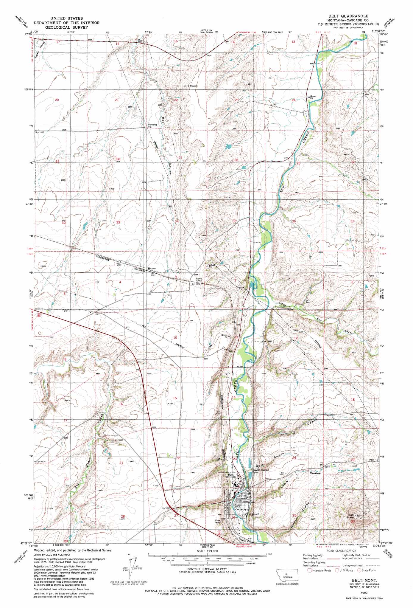
USGS Topo Quad 47110d8 - 1:24,000 scale
| Topo Map Name: | Belt |
| USGS Topo Quad ID: | 47110d8 |
| Print Size: | ca. 21 1/4" wide x 27" high |
| Southeast Coordinates: | 47.375° N latitude / 110.875° W longitude |
| Map Center Coordinates: | 47.4375° N latitude / 110.9375° W longitude |
| U.S. State: | MT |
| Filename: | o47110d8.jpg |
| Download Map JPG Image: | Belt topo map 1:24,000 scale |
| Map Type: | Topographic |
| Topo Series: | 7.5´ |
| Map Scale: | 1:24,000 |
| Source of Map Images: | United States Geological Survey (USGS) |
| Alternate Map Versions: |
Belt MT 1982, updated 1983 Download PDF Buy paper map Belt MT 2011 Download PDF Buy paper map Belt MT 2014 Download PDF Buy paper map |
1:24,000 Topo Quads surrounding Belt
Flick Lake |
Floweree |
Lander Crossing |
Rice Reservoir |
Shonkin Nw |
Northeast Great Falls |
Morony Dam |
Waltham |
Highwood |
Big Sag |
Southeast Great Falls |
Fife |
Belt |
Belt Ne |
Highwood Baldy |
Stockett |
Mahoney Hill |
Armington |
Blythe |
Raynesford |
Calvert |
Evans |
Riceville |
Monarch Ne |
Limestone Butte |
> Back to 47110a1 at 1:100,000 scale
> Back to 47110a1 at 1:250,000 scale
> Back to U.S. Topo Maps home
Belt topo map: Gazetteer
Belt: Mines
East Belt Mine elevation 1116m 3661′Belt: Parks
Castner Park elevation 1073m 3520′Belt: Populated Places
Belt elevation 1070m 3510′Belton (historical) elevation 1095m 3592′
Wayne elevation 1123m 3684′
Belt: Post Offices
Belt Post Office elevation 1072m 3517′Beltane Post Office (historical) elevation 1093m 3585′
Castner Post Office (historical) elevation 1098m 3602′
Wayne Post Office (historical) elevation 1123m 3684′
Belt: Streams
Little Belt Creek elevation 1043m 3421′Belt: Summits
Belt Butte elevation 1416m 4645′Belt: Tunnels
Wayne Tunnel elevation 1152m 3779′Belt: Valleys
B and M Coulee elevation 1080m 3543′French Coulee elevation 1086m 3562′
Graham Coulee elevation 1087m 3566′
Lewis Coulee elevation 1086m 3562′
Orr Coulee elevation 1078m 3536′
Belt: Wells
19N06E01____01 Well elevation 1136m 3727′19N06E02DCDA01 Well elevation 1063m 3487′
19N06E03B___01 Well elevation 1129m 3704′
19N06E05____01 Well elevation 1139m 3736′
19N06E05____02 Well elevation 1139m 3736′
19N06E10____01 Well elevation 1165m 3822′
19N06E11____01 Well elevation 1119m 3671′
19N06E11____02 Well elevation 1119m 3671′
19N06E11ACDA01 Well elevation 1051m 3448′
19N06E14____01 Well elevation 1064m 3490′
19N06E14____02 Well elevation 1064m 3490′
19N06E14____03 Well elevation 1064m 3490′
19N06E14____04 Well elevation 1064m 3490′
19N06E15____01 Well elevation 1172m 3845′
19N06E15____02 Well elevation 1172m 3845′
19N06E15____03 Well elevation 1172m 3845′
19N06E21____01 Well elevation 1178m 3864′
19N06E21____02 Well elevation 1178m 3864′
19N06E22D___01 Well elevation 1180m 3871′
19N06E23BADA01 Well elevation 1063m 3487′
19N06E26ACAD01 Well elevation 1072m 3517′
19N06E26ACCC01 Well elevation 1073m 3520′
20N06E13D___01 Well elevation 1016m 3333′
20N06E14BCA_01 Well elevation 1123m 3684′
20N06E15A___01 Well elevation 1074m 3523′
20N06E24A___01 Well elevation 1023m 3356′
20N06E25D___01 Well elevation 1063m 3487′
20N06E25D___02 Well elevation 1063m 3487′
20N06E26____01 Well elevation 1079m 3540′
20N06E32____01 Well elevation 1119m 3671′
20N06E32A___01 Well elevation 1108m 3635′
20N06E33DAC_01 Well elevation 1052m 3451′
20N06E35DDB_01 Well elevation 1047m 3435′
20N07E18D___01 Well elevation 1040m 3412′
Belt digital topo map on disk
Buy this Belt topo map showing relief, roads, GPS coordinates and other geographical features, as a high-resolution digital map file on DVD: