Lander Crossing Topo Map Montana
To zoom in, hover over the map of Lander Crossing
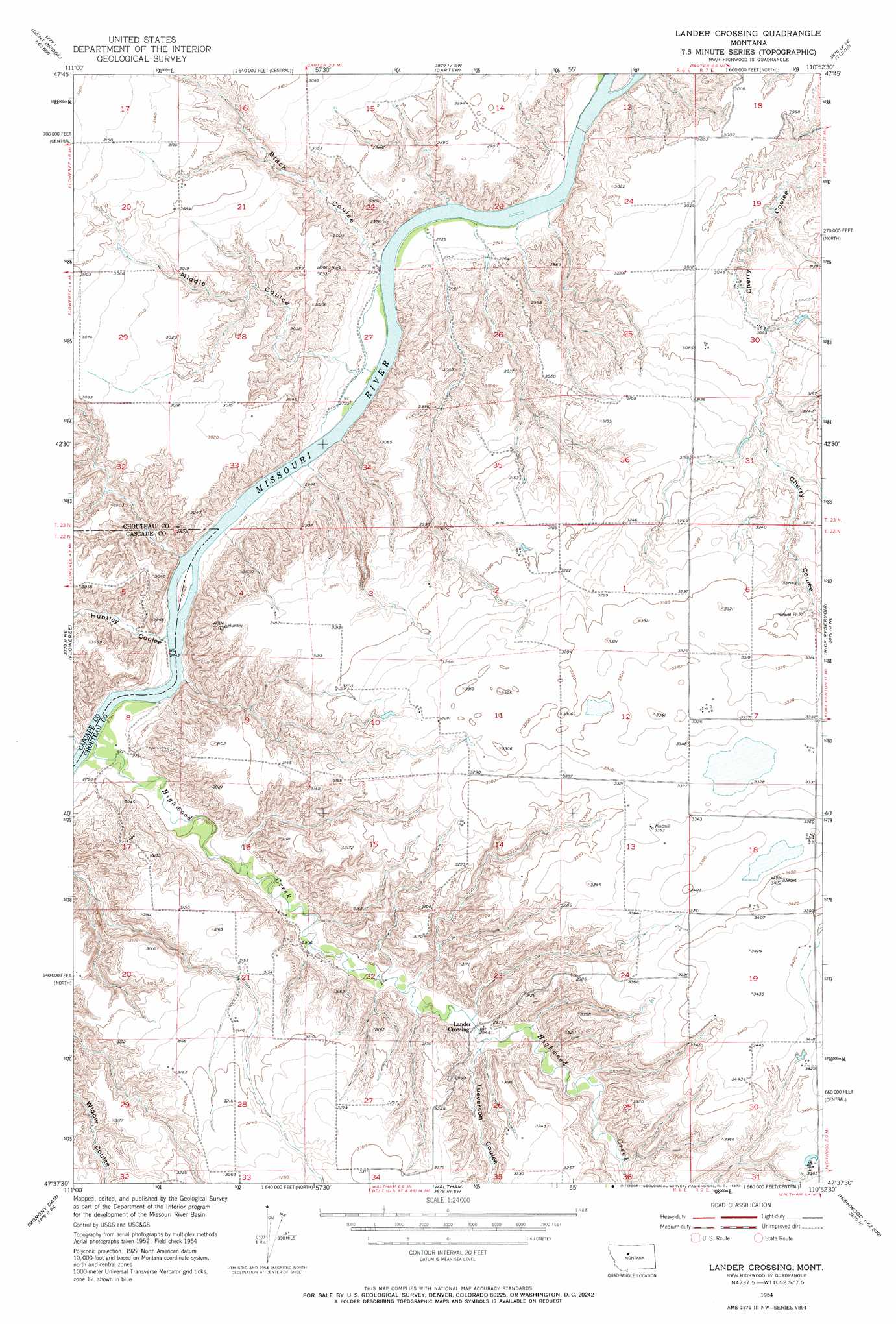
USGS Topo Quad 47110f8 - 1:24,000 scale
| Topo Map Name: | Lander Crossing |
| USGS Topo Quad ID: | 47110f8 |
| Print Size: | ca. 21 1/4" wide x 27" high |
| Southeast Coordinates: | 47.625° N latitude / 110.875° W longitude |
| Map Center Coordinates: | 47.6875° N latitude / 110.9375° W longitude |
| U.S. State: | MT |
| Filename: | o47110f8.jpg |
| Download Map JPG Image: | Lander Crossing topo map 1:24,000 scale |
| Map Type: | Topographic |
| Topo Series: | 7.5´ |
| Map Scale: | 1:24,000 |
| Source of Map Images: | United States Geological Survey (USGS) |
| Alternate Map Versions: |
Lander Crossing MT 1954, updated 1956 Download PDF Buy paper map Lander Crossing MT 1954, updated 1973 Download PDF Buy paper map Lander Crossing MT 2011 Download PDF Buy paper map Lander Crossing MT 2014 Download PDF Buy paper map |
1:24,000 Topo Quads surrounding Lander Crossing
Dent Bridge |
Dent Bridge Ne |
Apple School |
Carter Ne |
Fort Benton Nw |
Antelope Flat |
Antelope Lake |
Carter |
Tunis |
Fort Benton |
Flick Lake |
Floweree |
Lander Crossing |
Rice Reservoir |
Shonkin Nw |
Northeast Great Falls |
Morony Dam |
Waltham |
Highwood |
Big Sag |
Southeast Great Falls |
Fife |
Belt |
Belt Ne |
Highwood Baldy |
> Back to 47110e1 at 1:100,000 scale
> Back to 47110a1 at 1:250,000 scale
> Back to U.S. Topo Maps home
Lander Crossing topo map: Gazetteer
Lander Crossing: Populated Places
Lander Crossing elevation 898m 2946′Lander Crossing: Streams
Highwood Creek elevation 836m 2742′Lander Crossing: Valleys
Black Coulee elevation 831m 2726′Huntley Coulee elevation 835m 2739′
Middle Coulee elevation 837m 2746′
Ryan Coulee elevation 834m 2736′
Tueverson Coulee elevation 906m 2972′
Lander Crossing: Wells
22N06E09DDAB01 Well elevation 939m 3080′22N06E10CD__01 Well elevation 976m 3202′
22N07E07BCCA01 Well elevation 1015m 3330′
Lander Crossing digital topo map on disk
Buy this Lander Crossing topo map showing relief, roads, GPS coordinates and other geographical features, as a high-resolution digital map file on DVD: