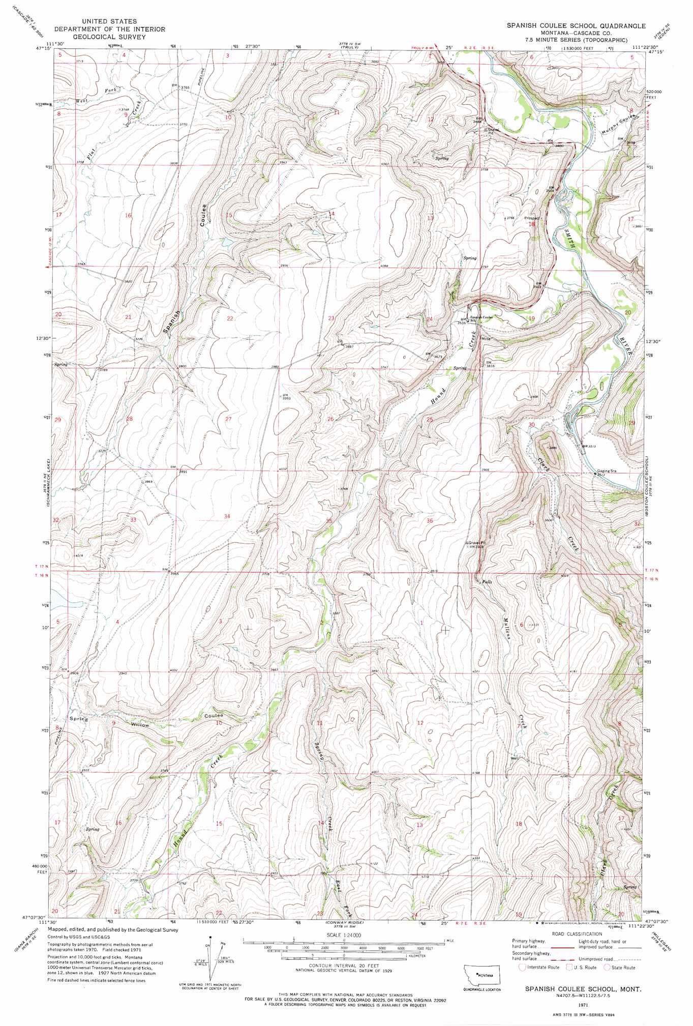
Spanish Coulee School Topo Map Montana
To zoom in, hover over the map of Spanish Coulee School
USGS Topo Quad 47111b4 - 1:24,000 scale
| Topo Map Name: | Spanish Coulee School |
| USGS Topo Quad ID: | 47111b4 |
| Print Size: | ca. 21 1/4" wide x 27" high |
| Southeast Coordinates: | 47.125° N latitude / 111.375° W longitude |
| Map Center Coordinates: | 47.1875° N latitude / 111.4375° W longitude |
| U.S. State: | MT |
| Filename: | o47111b4.jpg |
| Download Map JPG Image: | Spanish Coulee School topo map 1:24,000 scale |
| Map Type: | Topographic |
| Topo Series: | 7.5´ |
| Map Scale: | 1:24,000 |
| Source of Map Images: | United States Geological Survey (USGS) |
| Alternate Map Versions: |
Spanish Coulee School MT 1971, updated 1975 Download PDF Buy paper map Spanish Coulee School MT 2011 Download PDF Buy paper map Spanish Coulee School MT 2014 Download PDF Buy paper map |
1:24,000 Topo Quads surrounding Spanish Coulee School
Fair Haven Colony |
Ulm |
Antelope Butte |
Southwest Great Falls |
Southeast Great Falls |
Cascade |
Nelson Island |
Truly |
Eden |
Stockett |
Rocky Reef |
Schrammeck Lake |
Spanish Coulee School |
Boston Coulee School |
Calvert |
Hound Creek Reservoir |
Dana Ranch |
Conway Ridge |
Millegan |
Deep Creek Park |
Middle Creek Lake |
B K Ranch |
Lingshire Nw |
Lingshire Ne |
Bald Hills |
> Back to 47111a1 at 1:100,000 scale
> Back to 47110a1 at 1:250,000 scale
> Back to U.S. Topo Maps home
Spanish Coulee School topo map: Gazetteer
Spanish Coulee School: Dams
Leveque Reservoir Dam elevation 1127m 3697′Mesaros Dam elevation 1194m 3917′
Spaniard Dam elevation 1120m 3674′
Spanish Coulee School: Post Offices
Orr Post Office (historical) elevation 1051m 3448′Spanish Coulee School: Springs
17N02E09D___01 Spring elevation 1155m 3789′17N02E10A___01 Spring elevation 1108m 3635′
17N02E15D___01 Spring elevation 1139m 3736′
Spanish Coulee School: Streams
Clark Creek elevation 1067m 3500′East Fork Spring Creek elevation 1206m 3956′
Hound Creek elevation 1058m 3471′
Mullens Creek elevation 1086m 3562′
Spring Creek elevation 1098m 3602′
West Fork Flat Creek elevation 1123m 3684′
Spanish Coulee School: Valleys
Murphy Coulee elevation 1054m 3458′Spring Willow Coulee elevation 1107m 3631′
Spanish Coulee School: Wells
17N02E02DD__01 Well elevation 1115m 3658′17N02E09D___02 Well elevation 1130m 3707′
17N02E10A___02 Well elevation 1080m 3543′
17N02E24D___01 Well elevation 1080m 3543′
17N02E24D___02 Well elevation 1080m 3543′
17N02E28B___01 Well elevation 1170m 3838′
17N02E34A___01 Well elevation 1214m 3982′
17N02E34A___02 Well elevation 1214m 3982′
17N03E08B___01 Well elevation 1127m 3697′
17N03E08C___01 Well elevation 1054m 3458′
17N03E30____01 Well elevation 1085m 3559′
17N03E30____02 Well elevation 1085m 3559′
Spanish Coulee School digital topo map on disk
Buy this Spanish Coulee School topo map showing relief, roads, GPS coordinates and other geographical features, as a high-resolution digital map file on DVD: