Eden Topo Map Montana
To zoom in, hover over the map of Eden
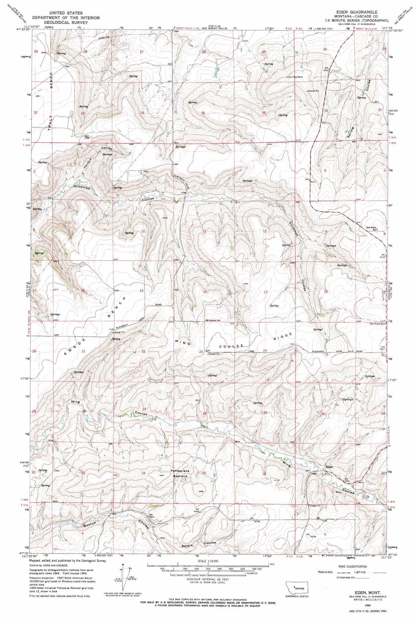
USGS Topo Quad 47111c3 - 1:24,000 scale
| Topo Map Name: | Eden |
| USGS Topo Quad ID: | 47111c3 |
| Print Size: | ca. 21 1/4" wide x 27" high |
| Southeast Coordinates: | 47.25° N latitude / 111.25° W longitude |
| Map Center Coordinates: | 47.3125° N latitude / 111.3125° W longitude |
| U.S. State: | MT |
| Filename: | o47111c3.jpg |
| Download Map JPG Image: | Eden topo map 1:24,000 scale |
| Map Type: | Topographic |
| Topo Series: | 7.5´ |
| Map Scale: | 1:24,000 |
| Source of Map Images: | United States Geological Survey (USGS) |
| Alternate Map Versions: |
Eden MT 1965, updated 1967 Download PDF Buy paper map Eden MT 2011 Download PDF Buy paper map Eden MT 2014 Download PDF Buy paper map |
1:24,000 Topo Quads surrounding Eden
Vaughn |
Manchester |
Northwest Great Falls |
Northeast Great Falls |
Morony Dam |
Ulm |
Antelope Butte |
Southwest Great Falls |
Southeast Great Falls |
Fife |
Nelson Island |
Truly |
Eden |
Stockett |
Mahoney Hill |
Schrammeck Lake |
Spanish Coulee School |
Boston Coulee School |
Calvert |
Evans |
Dana Ranch |
Conway Ridge |
Millegan |
Deep Creek Park |
Blankenbaker Flats |
> Back to 47111a1 at 1:100,000 scale
> Back to 47110a1 at 1:250,000 scale
> Back to U.S. Topo Maps home
Eden topo map: Gazetteer
Eden: Areas
Pettapiece Badland elevation 1244m 4081′Eden: Benches
Swede Bench elevation 1253m 4110′Eden: Populated Places
Eden elevation 1184m 3884′Eden: Post Offices
Eden Post Office (historical) elevation 1183m 3881′Eden: Ridges
Ming Coulee Ridge elevation 1309m 4294′Eden: Summits
Iverson Hill elevation 1223m 4012′Eden: Valleys
Pardais Coulee elevation 1097m 3599′Splain Coulee elevation 1160m 3805′
Eden: Wells
17N03E04C___01 Well elevation 1173m 3848′17N03E04C___02 Well elevation 1173m 3848′
17N03E04C___03 Well elevation 1173m 3848′
17N03E04C___04 Well elevation 1173m 3848′
17N03E04C___05 Well elevation 1173m 3848′
18N03E09____01 Well elevation 1221m 4005′
18N03E09____02 Well elevation 1221m 4005′
18N03E10____01 Well elevation 1218m 3996′
18N03E12____01 Well elevation 1277m 4189′
18N03E20D___01 Well elevation 1248m 4094′
18N03E21____01 Well elevation 1259m 4130′
18N03E23B___01 Well elevation 1280m 4199′
18N03E28A___01 Well elevation 1157m 3795′
18N04E31A___01 Well elevation 1259m 4130′
19N04E30C___01 Well elevation 1224m 4015′
19N04E30DBDD01 Well elevation 1188m 3897′
Eden digital topo map on disk
Buy this Eden topo map showing relief, roads, GPS coordinates and other geographical features, as a high-resolution digital map file on DVD: