Truly Topo Map Montana
To zoom in, hover over the map of Truly
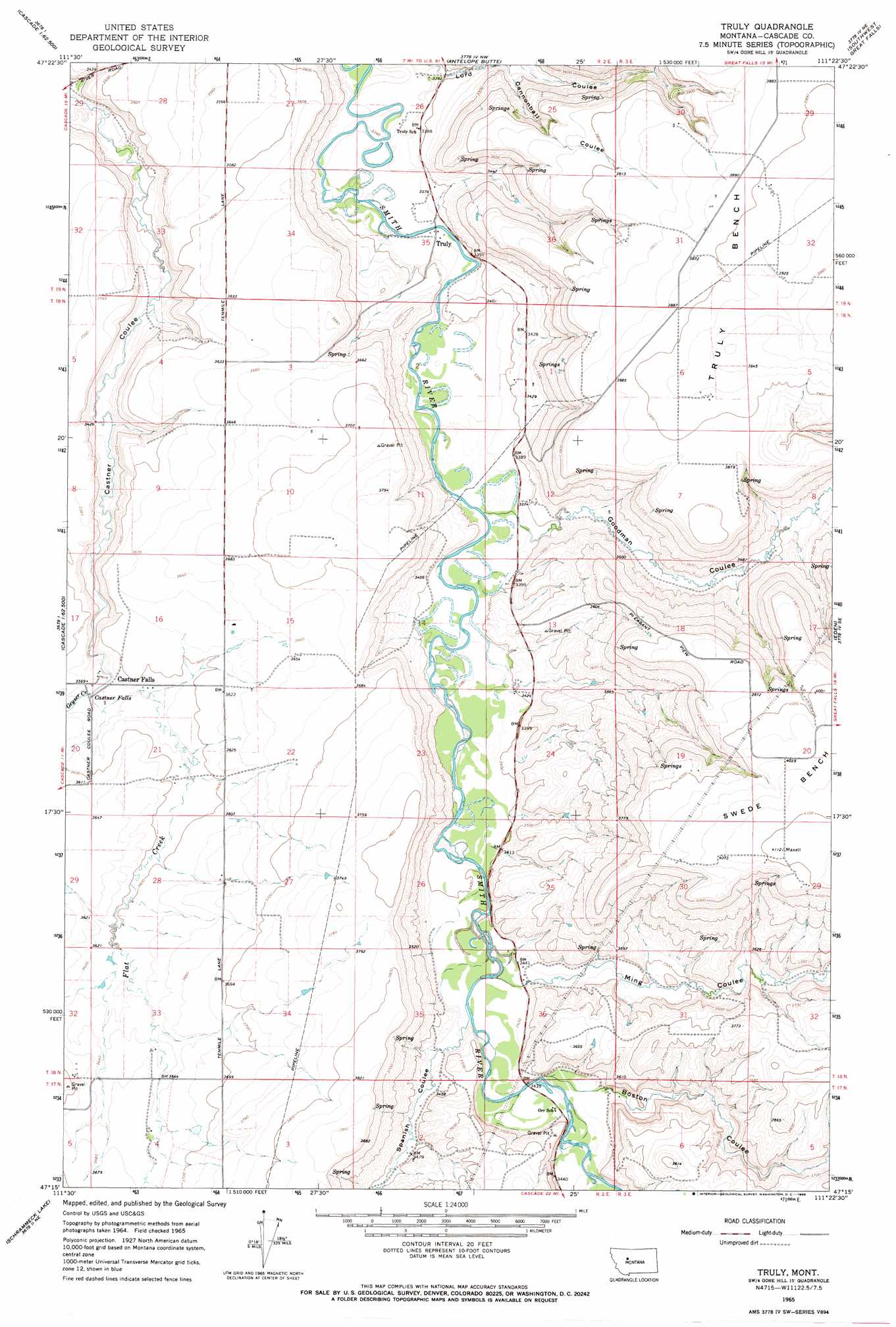
USGS Topo Quad 47111c4 - 1:24,000 scale
| Topo Map Name: | Truly |
| USGS Topo Quad ID: | 47111c4 |
| Print Size: | ca. 21 1/4" wide x 27" high |
| Southeast Coordinates: | 47.25° N latitude / 111.375° W longitude |
| Map Center Coordinates: | 47.3125° N latitude / 111.4375° W longitude |
| U.S. State: | MT |
| Filename: | o47111c4.jpg |
| Download Map JPG Image: | Truly topo map 1:24,000 scale |
| Map Type: | Topographic |
| Topo Series: | 7.5´ |
| Map Scale: | 1:24,000 |
| Source of Map Images: | United States Geological Survey (USGS) |
| Alternate Map Versions: |
Truly MT 1965, updated 1968 Download PDF Buy paper map Truly MT 2011 Download PDF Buy paper map Truly MT 2014 Download PDF Buy paper map |
1:24,000 Topo Quads surrounding Truly
Sun River |
Vaughn |
Manchester |
Northwest Great Falls |
Northeast Great Falls |
Fair Haven Colony |
Ulm |
Antelope Butte |
Southwest Great Falls |
Southeast Great Falls |
Cascade |
Nelson Island |
Truly |
Eden |
Stockett |
Rocky Reef |
Schrammeck Lake |
Spanish Coulee School |
Boston Coulee School |
Calvert |
Hound Creek Reservoir |
Dana Ranch |
Conway Ridge |
Millegan |
Deep Creek Park |
> Back to 47111a1 at 1:100,000 scale
> Back to 47110a1 at 1:250,000 scale
> Back to U.S. Topo Maps home
Truly topo map: Gazetteer
Truly: Benches
Truly Bench elevation 1193m 3914′Truly: Bridges
Truly Bridge elevation 1020m 3346′Truly: Falls
Castner Falls elevation 1080m 3543′Truly: Populated Places
Castner Falls elevation 1087m 3566′Truly elevation 1021m 3349′
Truly: Post Offices
Truly Post Office (historical) elevation 1021m 3349′Truly: Springs
18N02E33B___01 Spring elevation 1102m 3615′19N02E25B___01 Spring elevation 1054m 3458′
19N02E33A___01 Spring elevation 1090m 3576′
Truly: Streams
Flat Creek elevation 1080m 3543′Geyser Creek elevation 1080m 3543′
Truly: Valleys
Boston Coulee elevation 1050m 3444′Cannonball Coulee elevation 1052m 3451′
Goodman Coulee elevation 1030m 3379′
Ming Coulee elevation 1046m 3431′
Spanish Coulee elevation 1040m 3412′
Truly: Wells
17N02E01D___01 Well elevation 1047m 3435′17N02E02____01 Well elevation 1065m 3494′
17N02E04AD__01 Well elevation 1128m 3700′
17N02E04AD__02 Well elevation 1128m 3700′
17N02E04B___01 Well elevation 1119m 3671′
18N02E01C___01 Well elevation 1043m 3421′
18N02E01C___02 Well elevation 1043m 3421′
18N02E02____01 Well elevation 1022m 3353′
18N02E02____02 Well elevation 1022m 3353′
18N02E02C___01 Well elevation 1102m 3615′
18N02E03____01 Well elevation 1115m 3658′
18N02E03____02 Well elevation 1115m 3658′
18N02E03B___01 Well elevation 1114m 3654′
18N02E10A___01 Well elevation 1127m 3697′
18N02E10D___01 Well elevation 1139m 3736′
18N02E14D___01 Well elevation 1031m 3382′
18N02E16C___01 Well elevation 1100m 3608′
18N02E21____01 Well elevation 1094m 3589′
18N02E21____02 Well elevation 1094m 3589′
18N02E21A___01 Well elevation 1097m 3599′
18N02E22B___01 Well elevation 1115m 3658′
18N02E24B___01 Well elevation 1034m 3392′
18N02E27A___01 Well elevation 1143m 3750′
18N02E28____01 Well elevation 1099m 3605′
18N02E28A___01 Well elevation 1100m 3608′
18N02E28A___02 Well elevation 1100m 3608′
18N02E33C___01 Well elevation 1111m 3645′
18N02E33C___02 Well elevation 1111m 3645′
18N02E36B___01 Well elevation 1042m 3418′
18N02E36D___01 Well elevation 1113m 3651′
19N02E26____01 Well elevation 1025m 3362′
19N02E26B___01 Well elevation 1019m 3343′
19N02E26C___01 Well elevation 1018m 3339′
19N02E27A___01 Well elevation 1072m 3517′
19N02E28____01 Well elevation 1077m 3533′
19N02E28DDAB01 Well elevation 1089m 3572′
19N02E35D___01 Well elevation 1025m 3362′
19N03E29____01 Well elevation 1191m 3907′
19N03E31____01 Well elevation 1179m 3868′
Truly digital topo map on disk
Buy this Truly topo map showing relief, roads, GPS coordinates and other geographical features, as a high-resolution digital map file on DVD: