Mount Cecelia Topo Map Montana
To zoom in, hover over the map of Mount Cecelia
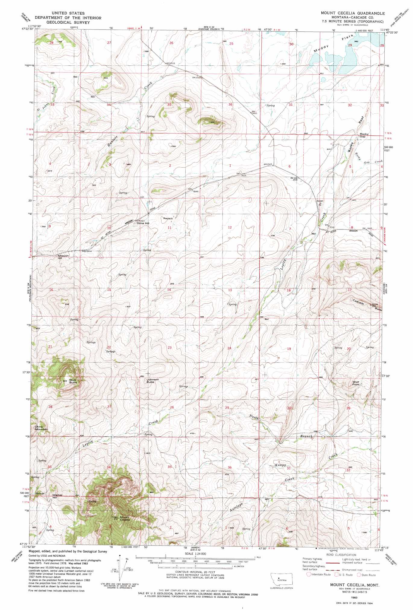
USGS Topo Quad 47111c7 - 1:24,000 scale
| Topo Map Name: | Mount Cecelia |
| USGS Topo Quad ID: | 47111c7 |
| Print Size: | ca. 21 1/4" wide x 27" high |
| Southeast Coordinates: | 47.25° N latitude / 111.75° W longitude |
| Map Center Coordinates: | 47.3125° N latitude / 111.8125° W longitude |
| U.S. State: | MT |
| Filename: | o47111c7.jpg |
| Download Map JPG Image: | Mount Cecelia topo map 1:24,000 scale |
| Map Type: | Topographic |
| Topo Series: | 7.5´ |
| Map Scale: | 1:24,000 |
| Source of Map Images: | United States Geological Survey (USGS) |
| Alternate Map Versions: |
Mount Cecelia MT 1983, updated 1983 Download PDF Buy paper map Mount Cecelia MT 2011 Download PDF Buy paper map Mount Cecelia MT 2014 Download PDF Buy paper map |
1:24,000 Topo Quads surrounding Mount Cecelia
Lowry |
Fairfield |
Fort Shaw |
Sun River |
Vaughn |
Bowmans Corners Ne |
Simms |
Cascade Colony |
Fair Haven Colony |
Ulm |
Henry Creek |
Telegraph Mountain |
Mount Cecelia |
Cascade |
Nelson Island |
Coburn Mountain |
Mid Canon |
Hardy |
Rocky Reef |
Schrammeck Lake |
Wolf Creek |
Craig |
The Sawteeth |
Hound Creek Reservoir |
Dana Ranch |
> Back to 47111a1 at 1:100,000 scale
> Back to 47110a1 at 1:250,000 scale
> Back to U.S. Topo Maps home
Mount Cecelia topo map: Gazetteer
Mount Cecelia: Capes
Wolf Point elevation 1216m 3989′Mount Cecelia: Dams
Spun Dam elevation 1048m 3438′Mount Cecelia: Gaps
Rocky Gap elevation 1050m 3444′Mount Cecelia: Springs
17N01W06B___01 Spring elevation 1240m 4068′18N01W29C___01 Spring elevation 1115m 3658′
Mount Cecelia: Streams
Hunters Creek elevation 1043m 3421′Lepley Creek elevation 1041m 3415′
North Branch Knapp Creek elevation 1069m 3507′
Mount Cecelia: Summits
Cascade Butte elevation 1370m 4494′China Mountain elevation 1591m 5219′
Dime Hill elevation 1154m 3786′
Johnson Butte elevation 1411m 4629′
Mission Hill elevation 1248m 4094′
Mount Cecelia elevation 1869m 6131′
Skull Butte elevation 1725m 5659′
Warner Hill elevation 1494m 4901′
Mount Cecelia: Wells
17N01W05A___01 Well elevation 1086m 3562′18N01W07C___01 Well elevation 1160m 3805′
18N01W07D___01 Well elevation 1097m 3599′
18N01W18C___01 Well elevation 1136m 3727′
18N01W31A___01 Well elevation 1135m 3723′
18N01W31A___02 Well elevation 1135m 3723′
18N01W32A___01 Well elevation 1076m 3530′
Mount Cecelia digital topo map on disk
Buy this Mount Cecelia topo map showing relief, roads, GPS coordinates and other geographical features, as a high-resolution digital map file on DVD: