Wolf Creek Topo Map Montana
To zoom in, hover over the map of Wolf Creek
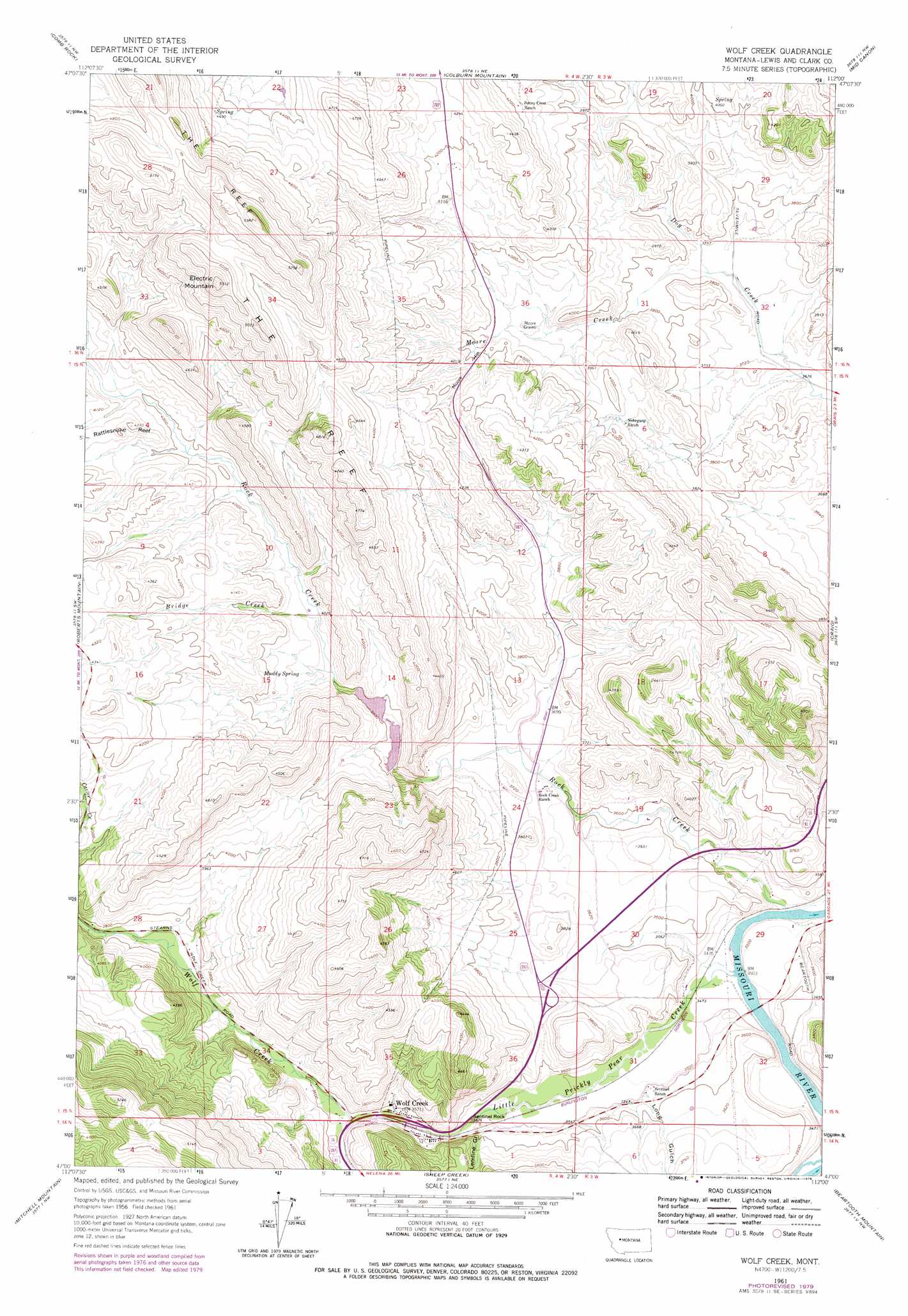
USGS Topo Quad 47112a1 - 1:24,000 scale
| Topo Map Name: | Wolf Creek |
| USGS Topo Quad ID: | 47112a1 |
| Print Size: | ca. 21 1/4" wide x 27" high |
| Southeast Coordinates: | 47° N latitude / 112° W longitude |
| Map Center Coordinates: | 47.0625° N latitude / 112.0625° W longitude |
| U.S. State: | MT |
| Filename: | o47112a1.jpg |
| Download Map JPG Image: | Wolf Creek topo map 1:24,000 scale |
| Map Type: | Topographic |
| Topo Series: | 7.5´ |
| Map Scale: | 1:24,000 |
| Source of Map Images: | United States Geological Survey (USGS) |
| Alternate Map Versions: |
Wolf Creek MT 1961, updated 1964 Download PDF Buy paper map Wolf Creek MT 1961, updated 1979 Download PDF Buy paper map Wolf Creek MT 1961, updated 1979 Download PDF Buy paper map Wolf Creek MT 2011 Download PDF Buy paper map Wolf Creek MT 2014 Download PDF Buy paper map |
1:24,000 Topo Quads surrounding Wolf Creek
Krone Ranch |
Bowmans Corners |
Henry Creek |
Telegraph Mountain |
Mount Cecelia |
Johnson Mountain |
Comb Rock |
Coburn Mountain |
Mid Canon |
Hardy |
Rogers Pass |
Roberts Mountain |
Wolf Creek |
Craig |
The Sawteeth |
Wilborn |
Mitchell Mountain |
Sheep Creek |
Beartooth Mountain |
Candle Mountain |
Canyon Creek |
Silver City |
Rattlesnake Mountain |
Upper Holter Lake |
Nelson |
> Back to 47112a1 at 1:100,000 scale
> Back to 47112a1 at 1:250,000 scale
> Back to U.S. Topo Maps home
Wolf Creek topo map: Gazetteer
Wolf Creek: Bridges
Little Prickly Pear Creek Bridge elevation 1085m 3559′Wolf Creek Bridge elevation 1094m 3589′
Wolf Creek: Crossings
Interchange 226 elevation 1086m 3562′Interchange 228 elevation 1124m 3687′
Wolf Creek: Dams
Curran-Barrett Number 2 Dam elevation 1154m 3786′Deerborn Reservoir Dam elevation 1145m 3756′
Wolf Creek: Pillars
Sentinel Rock elevation 1086m 3562′Wolf Creek: Populated Places
Wolf Creek elevation 1086m 3562′Wolf Creek: Post Offices
Power Post Office (historical) elevation 1108m 3635′Spring Creek Post Office (historical) elevation 1158m 3799′
Wolf Creek Post Office elevation 1086m 3562′
Wolf Creek: Ridges
The Reef elevation 1520m 4986′Wolf Creek: Springs
Muddy Spring elevation 1188m 3897′Wolf Creek: Streams
Bridge Creek elevation 1170m 3838′Little Prickly Pear Creek elevation 1056m 3464′
Moore Creek elevation 1139m 3736′
Rock Creek elevation 1055m 3461′
Wolf Creek elevation 1092m 3582′
Wolf Creek: Summits
Electric Mountain elevation 1609m 5278′Moore Hill elevation 1246m 4087′
Wolf Creek: Valleys
Acres Gulch elevation 1117m 3664′Lemline Gulch elevation 1096m 3595′
Long Gulch elevation 1074m 3523′
Wolf Creek: Wells
15N04W03BB__01 Well elevation 1118m 3667′Wolf Creek digital topo map on disk
Buy this Wolf Creek topo map showing relief, roads, GPS coordinates and other geographical features, as a high-resolution digital map file on DVD: