Ovando Topo Map Montana
To zoom in, hover over the map of Ovando
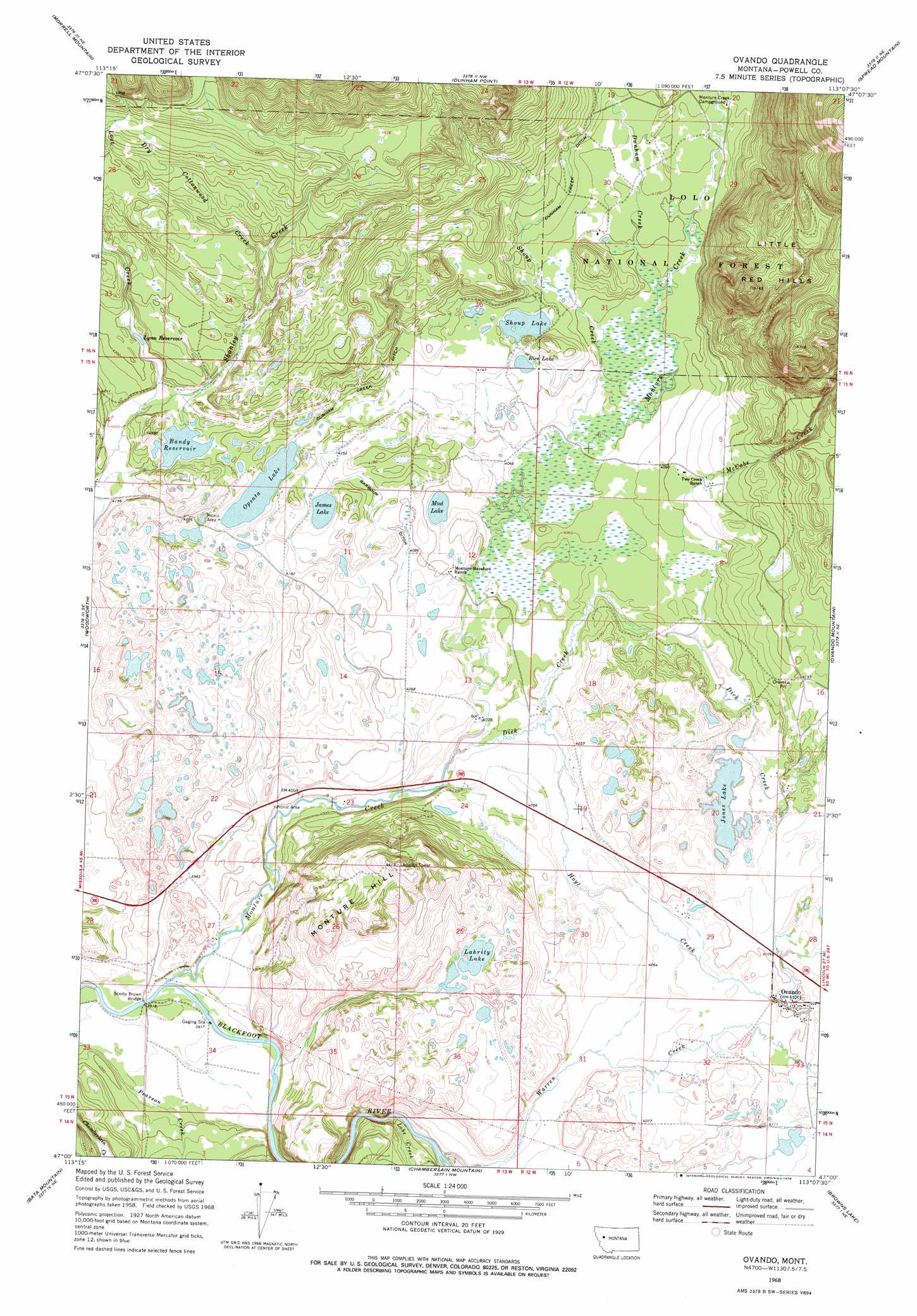
USGS Topo Quad 47113a2 - 1:24,000 scale
| Topo Map Name: | Ovando |
| USGS Topo Quad ID: | 47113a2 |
| Print Size: | ca. 21 1/4" wide x 27" high |
| Southeast Coordinates: | 47° N latitude / 113.125° W longitude |
| Map Center Coordinates: | 47.0625° N latitude / 113.1875° W longitude |
| U.S. State: | MT |
| Filename: | o47113a2.jpg |
| Download Map JPG Image: | Ovando topo map 1:24,000 scale |
| Map Type: | Topographic |
| Topo Series: | 7.5´ |
| Map Scale: | 1:24,000 |
| Source of Map Images: | United States Geological Survey (USGS) |
| Alternate Map Versions: |
Ovando MT 1968, updated 1971 Download PDF Buy paper map Ovando MT 1968, updated 1978 Download PDF Buy paper map Ovando MT 1999, updated 2003 Download PDF Buy paper map Ovando MT 2011 Download PDF Buy paper map Ovando MT 2014 Download PDF Buy paper map |
| FStopo: | US Forest Service topo Ovando is available: Download FStopo PDF Download FStopo TIF |
1:24,000 Topo Quads surrounding Ovando
Morrell Lake |
Crimson Peak |
Hahn Creek Pass |
Danaher Mountain |
Flint Mountain |
Seeley Lake East |
Morrell Mountain |
Dunham Point |
Spread Mountain |
Lake Mountain |
Salmon Lake |
Woodworth |
Ovando |
Ovando Mountain |
Coopers Lake |
Greenough |
Bata Mountain |
Chamberlain Mountain |
Browns Lake |
Marcum Mountain |
Union Peak |
Elevation Mountain |
Wild Horse Parks |
Chimney Lakes |
Helmville |
> Back to 47113a1 at 1:100,000 scale
> Back to 47112a1 at 1:250,000 scale
> Back to U.S. Topo Maps home
Ovando topo map: Gazetteer
Ovando: Bridges
Scotty Brown Bridge elevation 1192m 3910′Ovando: Canals
Barbour Ditch elevation 1256m 4120′Dunham Creek Ditch elevation 1276m 4186′
Ovando: Dams
Bandy Reservoir Dam elevation 1287m 4222′Shoup Lake Dam elevation 1261m 4137′
Ovando: Lakes
James Lake elevation 1261m 4137′Jones Lake elevation 1246m 4087′
Lahrity Lake elevation 1267m 4156′
Mud Lake elevation 1244m 4081′
Rice Lake elevation 1255m 4117′
Shoup Lake elevation 1261m 4137′
Upsata Lake elevation 1261m 4137′
Ovando: Populated Places
Ovando elevation 1246m 4087′Ovando: Post Offices
Ovando Post Office elevation 1246m 4087′Ovando: Reservoirs
Bandy Reservoir elevation 1284m 4212′Lynn Reservoir elevation 1302m 4271′
Ovando: Streams
Dick Creek elevation 1219m 3999′Dry Cottonwood Creek elevation 1285m 4215′
Dunham Creek elevation 1243m 4078′
Hoyt Creek elevation 1225m 4019′
Lobe Creek elevation 1208m 3963′
Lost Creek elevation 1356m 4448′
McCabe Creek elevation 1243m 4078′
Pearson Creek elevation 1202m 3943′
Shoup Creek elevation 1236m 4055′
Warren Creek elevation 1211m 3973′
Ovando: Summits
Little Red Hills elevation 1558m 5111′Monture Hill elevation 1406m 4612′
Ovando: Wells
15N12W05CDCA01 Well elevation 1260m 4133′15N12W29BDBD01 Well elevation 1245m 4084′
15N12W32CABC01 Well elevation 1244m 4081′
15N12W33BBAA01 Well elevation 1258m 4127′
15N12W33BBBA01 Well elevation 1251m 4104′
15N12W33BBBA02 Well elevation 1250m 4101′
16N12W30AACC01 Well elevation 1264m 4146′
Ovando digital topo map on disk
Buy this Ovando topo map showing relief, roads, GPS coordinates and other geographical features, as a high-resolution digital map file on DVD: