Woodworth Topo Map Montana
To zoom in, hover over the map of Woodworth
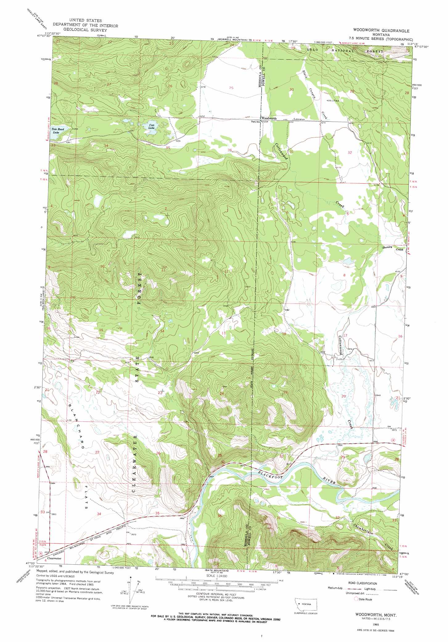
USGS Topo Quad 47113a3 - 1:24,000 scale
| Topo Map Name: | Woodworth |
| USGS Topo Quad ID: | 47113a3 |
| Print Size: | ca. 21 1/4" wide x 27" high |
| Southeast Coordinates: | 47° N latitude / 113.25° W longitude |
| Map Center Coordinates: | 47.0625° N latitude / 113.3125° W longitude |
| U.S. State: | MT |
| Filename: | o47113a3.jpg |
| Download Map JPG Image: | Woodworth topo map 1:24,000 scale |
| Map Type: | Topographic |
| Topo Series: | 7.5´ |
| Map Scale: | 1:24,000 |
| Source of Map Images: | United States Geological Survey (USGS) |
| Alternate Map Versions: |
Woodworth MT 1965, updated 1968 Download PDF Buy paper map Woodworth MT 1999, updated 2003 Download PDF Buy paper map Woodworth MT 2011 Download PDF Buy paper map Woodworth MT 2014 Download PDF Buy paper map |
| FStopo: | US Forest Service topo Woodworth is available: Download FStopo PDF Download FStopo TIF |
1:24,000 Topo Quads surrounding Woodworth
Lake Inez |
Morrell Lake |
Crimson Peak |
Hahn Creek Pass |
Danaher Mountain |
Seeley Lake West |
Seeley Lake East |
Morrell Mountain |
Dunham Point |
Spread Mountain |
Belmont Point |
Salmon Lake |
Woodworth |
Ovando |
Ovando Mountain |
Potomac |
Greenough |
Bata Mountain |
Chamberlain Mountain |
Browns Lake |
Mineral Ridge |
Union Peak |
Elevation Mountain |
Wild Horse Parks |
Chimney Lakes |
> Back to 47113a1 at 1:100,000 scale
> Back to 47112a1 at 1:250,000 scale
> Back to U.S. Topo Maps home
Woodworth topo map: Gazetteer
Woodworth: Airports
Buffalo Trail Ranch Strip elevation 1193m 3914′Woodworth: Flats
Blanchard Flats elevation 1230m 4035′Woodworth: Lakes
Cott Lake elevation 1288m 4225′Tote Road Lake elevation 1287m 4222′
Woodworth: Parks
Cottonwood Park elevation 1314m 4311′Woodworth: Populated Places
Woodworth elevation 1292m 4238′Woodworth: Post Offices
Woodworth Post Office (historical) elevation 1292m 4238′Woodworth: Streams
Black Canyon Creek elevation 1287m 4222′Chamberlain Creek elevation 1187m 3894′
Cottonwood Creek elevation 1181m 3874′
Shanley Creek elevation 1247m 4091′
Woodworth: Wells
15N13W20BABB01 Well elevation 1212m 3976′15N13W29CDBD01 Well elevation 1197m 3927′
15N13W32ACCA01 Well elevation 1191m 3907′
15N14W25DBDD01 Well elevation 1177m 3861′
15N14W36BCDB01 Well elevation 1171m 3841′
16N14W25AADA01 Well elevation 1317m 4320′
16N14W25BCCB01 Well elevation 1308m 4291′
16N14W25CDDC01 Well elevation 1295m 4248′
Woodworth digital topo map on disk
Buy this Woodworth topo map showing relief, roads, GPS coordinates and other geographical features, as a high-resolution digital map file on DVD: