Spread Mountain Topo Map Montana
To zoom in, hover over the map of Spread Mountain
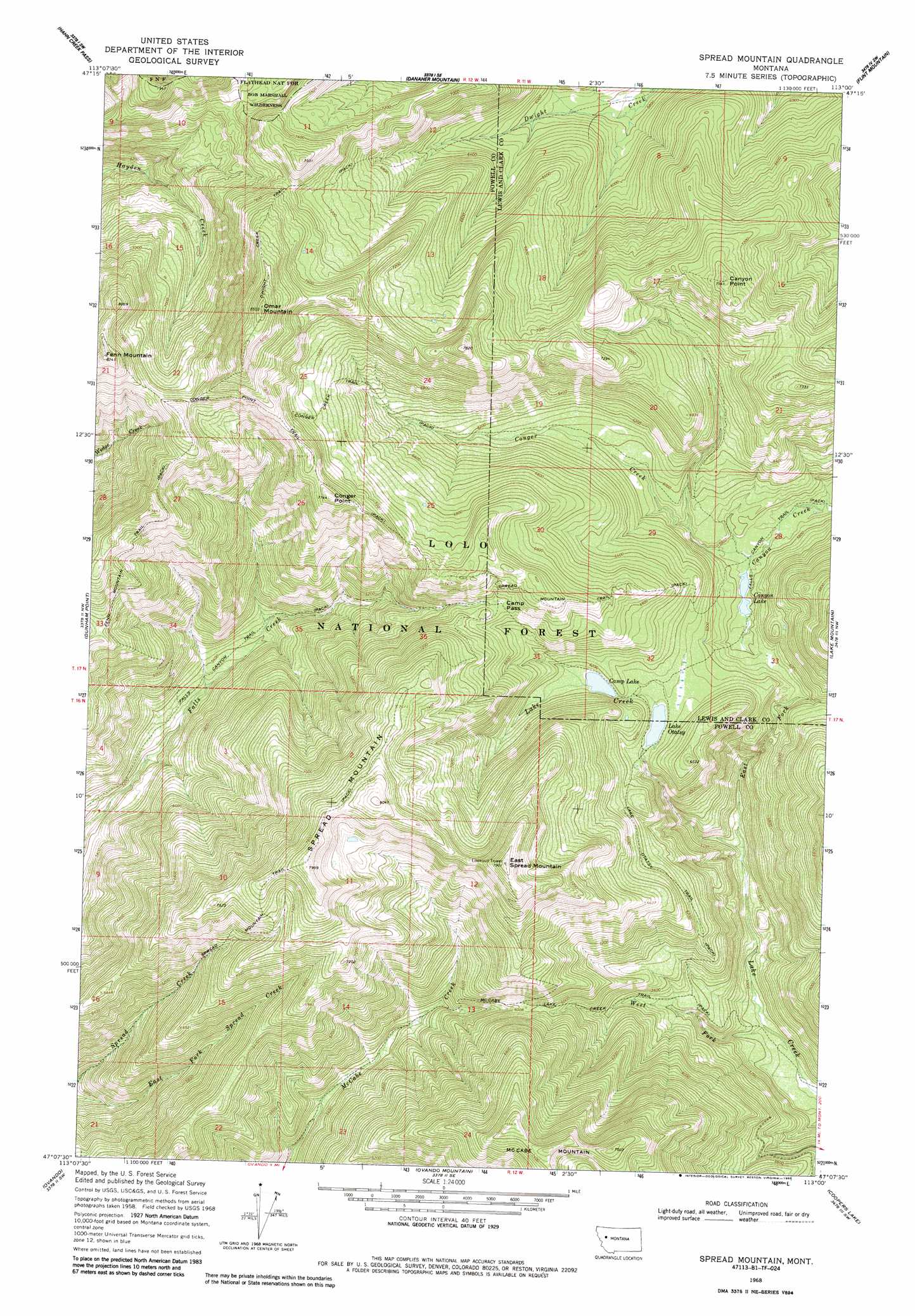
USGS Topo Quad 47113b1 - 1:24,000 scale
| Topo Map Name: | Spread Mountain |
| USGS Topo Quad ID: | 47113b1 |
| Print Size: | ca. 21 1/4" wide x 27" high |
| Southeast Coordinates: | 47.125° N latitude / 113° W longitude |
| Map Center Coordinates: | 47.1875° N latitude / 113.0625° W longitude |
| U.S. State: | MT |
| Filename: | o47113b1.jpg |
| Download Map JPG Image: | Spread Mountain topo map 1:24,000 scale |
| Map Type: | Topographic |
| Topo Series: | 7.5´ |
| Map Scale: | 1:24,000 |
| Source of Map Images: | United States Geological Survey (USGS) |
| Alternate Map Versions: |
Spread Mountain MT 1968, updated 1970 Download PDF Buy paper map Spread Mountain MT 1968, updated 1981 Download PDF Buy paper map Spread Mountain MT 1968, updated 1985 Download PDF Buy paper map Spread Mountain MT 1999, updated 2003 Download PDF Buy paper map Spread Mountain MT 2011 Download PDF Buy paper map Spread Mountain MT 2014 Download PDF Buy paper map |
| FStopo: | US Forest Service topo Spread Mountain is available: Download FStopo PDF Download FStopo TIF |
1:24,000 Topo Quads surrounding Spread Mountain
Una Mountain |
Pilot Peak |
Trap Mountain |
Benchmark |
Wood Lake |
Crimson Peak |
Hahn Creek Pass |
Danaher Mountain |
Flint Mountain |
Scapegoat Mountain |
Morrell Mountain |
Dunham Point |
Spread Mountain |
Lake Mountain |
Olson Peak |
Woodworth |
Ovando |
Ovando Mountain |
Coopers Lake |
Arrastra Mountain |
Bata Mountain |
Chamberlain Mountain |
Browns Lake |
Marcum Mountain |
Moose Creek |
> Back to 47113a1 at 1:100,000 scale
> Back to 47112a1 at 1:250,000 scale
> Back to U.S. Topo Maps home
Spread Mountain topo map: Gazetteer
Spread Mountain: Gaps
Camp Pass elevation 2061m 6761′Spread Mountain: Lakes
Camp Lake elevation 1873m 6145′Canyon Lake elevation 1752m 5748′
Lake Otatsy elevation 1850m 6069′
Spread Mountain: Streams
Conger Creek elevation 1748m 5734′East Fork Lake Creek elevation 1566m 5137′
West Fork Lake Creek elevation 1503m 4931′
Spread Mountain: Summits
Canyon Point elevation 2296m 7532′Conger Point elevation 2355m 7726′
East Spread Mountain elevation 2383m 7818′
Fenn Mountain elevation 2509m 8231′
Omar Mountain elevation 2586m 8484′
Spread Mountain elevation 2449m 8034′
Spread Mountain: Trails
Conger Creek Trail elevation 2016m 6614′Conger Point Trail elevation 2360m 7742′
Dwight Creek Trail elevation 2402m 7880′
Falls Canyon Trail elevation 2008m 6587′
Fenn Mountain Trail elevation 2326m 7631′
Lake Otatsy Trail elevation 1890m 6200′
McCabe Lake Creek Trail elevation 1784m 5853′
Spread Mountain Trail elevation 2080m 6824′
Spread Mountain digital topo map on disk
Buy this Spread Mountain topo map showing relief, roads, GPS coordinates and other geographical features, as a high-resolution digital map file on DVD: