Trap Mountain Topo Map Montana
To zoom in, hover over the map of Trap Mountain
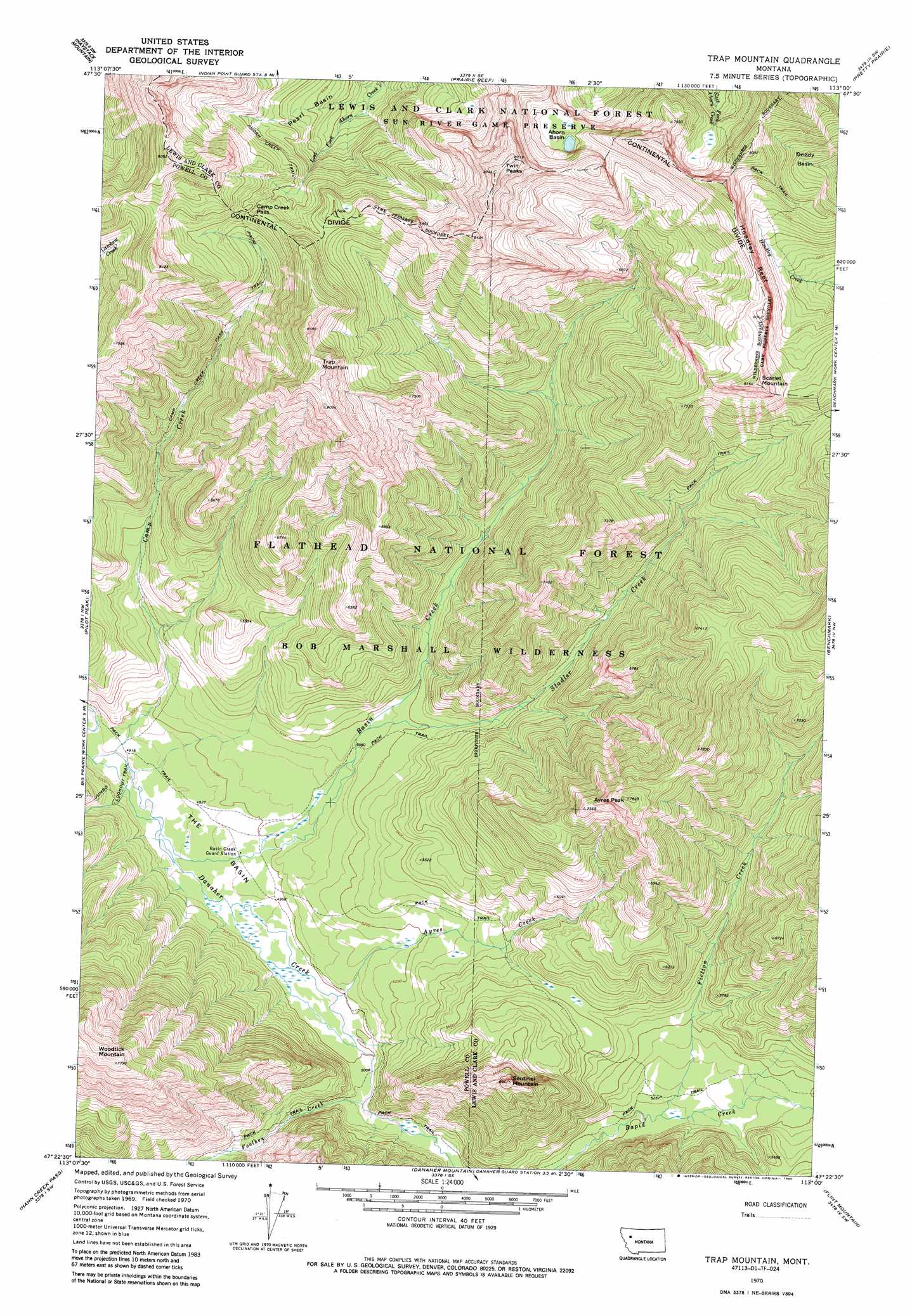
USGS Topo Quad 47113d1 - 1:24,000 scale
| Topo Map Name: | Trap Mountain |
| USGS Topo Quad ID: | 47113d1 |
| Print Size: | ca. 21 1/4" wide x 27" high |
| Southeast Coordinates: | 47.375° N latitude / 113° W longitude |
| Map Center Coordinates: | 47.4375° N latitude / 113.0625° W longitude |
| U.S. State: | MT |
| Filename: | o47113d1.jpg |
| Download Map JPG Image: | Trap Mountain topo map 1:24,000 scale |
| Map Type: | Topographic |
| Topo Series: | 7.5´ |
| Map Scale: | 1:24,000 |
| Source of Map Images: | United States Geological Survey (USGS) |
| Alternate Map Versions: |
Trap Mountain MT 1970, updated 1973 Download PDF Buy paper map Trap Mountain MT 1970, updated 1985 Download PDF Buy paper map Trap Mountain MT 1994, updated 1997 Download PDF Buy paper map Trap Mountain MT 2011 Download PDF Buy paper map Trap Mountain MT 2014 Download PDF Buy paper map |
| FStopo: | US Forest Service topo Trap Mountain is available: Download FStopo PDF Download FStopo TIF |
1:24,000 Topo Quads surrounding Trap Mountain
Pagoda Mountain |
Amphitheatre Mountain |
Slategoat Mountain |
Glenn Creek |
Arsenic Peak |
Big Salmon Lake East |
Haystack Mountain |
Prairie Reef |
Pretty Prairie |
Patricks Basin |
Una Mountain |
Pilot Peak |
Trap Mountain |
Benchmark |
Wood Lake |
Crimson Peak |
Hahn Creek Pass |
Danaher Mountain |
Flint Mountain |
Scapegoat Mountain |
Morrell Mountain |
Dunham Point |
Spread Mountain |
Lake Mountain |
Olson Peak |
> Back to 47113a1 at 1:100,000 scale
> Back to 47112a1 at 1:250,000 scale
> Back to U.S. Topo Maps home
Trap Mountain topo map: Gazetteer
Trap Mountain: Basins
Ahorn Basin elevation 2239m 7345′Pearl Basin elevation 2016m 6614′
The Basin elevation 1510m 4954′
Trap Mountain: Cliffs
Hoadley Reef elevation 2339m 7673′Trap Mountain: Gaps
Camp Creek Pass elevation 2177m 7142′Trap Mountain: Streams
Ayres Creek elevation 1521m 4990′Basin Creek elevation 1497m 4911′
Camp Creek elevation 1488m 4881′
Fiction Creek elevation 1594m 5229′
Foolhen Creek elevation 1532m 5026′
Stadler Creek elevation 1567m 5141′
Trap Mountain: Summits
Ayres Peak elevation 2382m 7814′Scarlet Mountain elevation 2478m 8129′
Sentinel Mountain elevation 2116m 6942′
Trap Mountain elevation 2480m 8136′
Twin Peaks elevation 2664m 8740′
Woodtick Mountain elevation 2366m 7762′
Trap Mountain: Trails
Ahorn Creek Trail elevation 2110m 6922′Camp Creek Pass Trail elevation 1898m 6227′
Trap Mountain digital topo map on disk
Buy this Trap Mountain topo map showing relief, roads, GPS coordinates and other geographical features, as a high-resolution digital map file on DVD: